

To view the latest Oklahoma drought map, CLICK HERE.
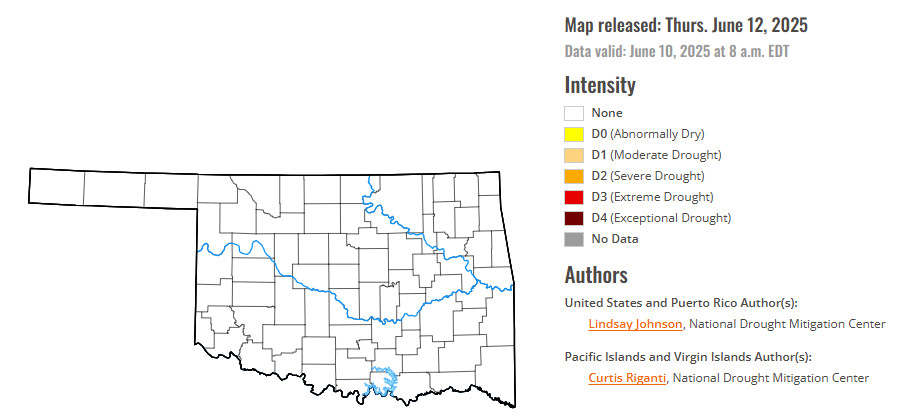
According to the latest Oklahoma drought monitor report, exceptional drought remains at zero percent, unchanged from the start of the calendar year.
Extreme drought or worse conditions remain at zero percent, unchanged since the week of October 29, 2024.
Severe drought or worse conditions remain at zero percent, unchanged since the week of May 29, 2025.
Moderate drought or worse conditions remain at zero percent, unchanged since last week.
Abnormally dry or worse conditions have decreased to zero percent, down from 9.83 percent last week.
According to the 6-to-10-day precipitation outlook map, the entire state of Oklahoma, is leaning above 33-40% chance of precipitation through June 21.
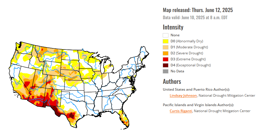
To view the United States Drought Map, CLICK HERE.
This week brought sharp weather contrasts across the U.S. The central Plains were 5 to 10 degrees cooler than normal, while the Pacific Northwest was 5 to 10 degrees warmer than average. A broad stretch from Texas through the Midwest to the Northeast received well above-normal rainfall, helping to ease drought conditions, while much of the West, northern High Plains and Florida remained dry, with many areas receiving just 5 to 25 percent of normal precipitation. These patterns led to widespread drought improvements across the High Plains, Midwest, South, and Northeast, particularly from northern Texas to southern Illinois, where 1 to 3 inches of rain reduced short-term dryness. Kansas, Nebraska, and eastern Colorado saw significant gains, while drought worsened in north-central Kansas, northwestern Colorado, and western Wyoming. Southwestern South Dakota and eastern Wyoming also improved. In the Midwest, drought eased in Missouri, Illinois, Indiana, and Michigan, but degraded in northern Minnesota and eastern Iowa. The Southwest benefited from rare early June rainfall and an unusually wet spring, with Arizona, southern Utah, southern Nevada, and parts of California improving after receiving 4 to 8 times their typical rainfall. New Mexico saw minor improvements in the southeast but stayed dry elsewhere. In the West, drought continued to worsen in Montana, northern Utah, and southeastern Wyoming due to ongoing dryness and low snowpack. Conditions in the Northwest are quickly degrading with well below-normal precipitation. The Southeast had mixed results—southern Georgia, the Carolinas and northeast Florida, and the Panhandle improved, while southern Florida remained dry. The Northeast continued its gradual recovery with steady rain. Alaska saw no changes, Puerto Rico remained drought-free, and Hawaii experienced mostly minor degradations.
In the Southern Plains, especially in Texas and Oklahoma, heavy rain led to drought improvements in many areas. Northern and central Texas saw improvements, while southern and western Texas only received enough precipitation to lead to one-category improvements along the border of the drought area. Oklahoma received a lot of rain and showed clear signs of recovery. Other southern states like Arkansas, Louisiana, Mississippi, and Tennessee, conditions continue to be stable.
The High Plains experienced a mix of drought improvements and degradations over the past week, driven by rainfall. Kansas saw the most widespread improvements, especially in the southern and eastern regions, where many areas received over two inches of rain, leading to significant one-category upgrades. However, north-central Kansas received less precipitation, and drought conditions there either persisted or worsened. Nebraska also benefited from recent storms, with helpful rainfall improving conditions in the central and southeastern parts of the state, though some areas now show signs of short-term moisture surplus. Colorado had a similar split. While much of the central and eastern regions received beneficial rainfall and saw improvements, the northwestern and southwestern corners remained dry and experienced drought deterioration. Wyoming followed an east–west divide as well: rain improved conditions in the central and eastern areas, but the west remained dry, resulting in further degradation. Long-term moisture deficits and below-average snowmelt runoff continue to be a concern across western parts of both Colorado and Wyoming. In South Dakota, the southwest corner received 1 to 3 inches of rain, leading to localized improvement, while the rest of the state remained mostly unchanged. North Dakota saw little change overall, with limited but sufficient moisture keeping conditions stable.
The West saw a mix of drought relief and worsening conditions this past week, with the most notable improvements concentrated in the Southwest due to rare early June rainfall. Parts of western and central Arizona, southern Nevada, and southwestern California received between 1–2 inches of rain. Even light to moderate amounts made a big impact, leading to broad one-category improvements in drought severity. New Mexico’s southeastern areas saw some improvement from the same rainfall that led to improvements in Texas. Elsewhere in the West, conditions were less favorable. The Intermountain West, including northern Utah, largely missed recent storms and saw continued drought deterioration. Montana faced some of the worst conditions in the region. Dry weather and below-normal snowpack led to expanding drought across the northwest and central parts of the state, raising concerns as the region enters the warmest part of the year with limited water reserves. The Pacific Northwest—covering Washington, Oregon, and Idaho—remained relatively stable this week, with no major shifts. However, dryness is quickly appearing across the region, where conditions will need continued monitoring.
Looking ahead, over the next five to seven days, heavy precipitation is expected across several regions. Eastern Texas, southeastern Oklahoma, and Arkansas will experience significant rainfall, which will continue through the Ohio River area and Pennsylvania. The northern Midwest and High Plains are also expected to receive moderate rainfall, with two to four inches expected in parts of northern Minnesota and northeastern Iowa. Nebraska is forecasted to see above-normal precipitation. Meanwhile, the West Coast will miss out on significant rain, with little to no precipitation expected from Washington down through eastern Colorado and New Mexico.
The six to 10 day outlook shows below-normal temperatures in the Pacific Northwest, while above-normal temperatures are expected across the rest of the lower 48 states, Alaska, and Hawaii. The greatest chances for above-normal temperatures are in Utah, Colorado, southern Wyoming, and across the southeast, from southern Louisiana to West Virginia. Above-normal precipitation is more likely in the Pacific Northwest, northern High Plains, upper Midwest, southern Texas, western Louisiana, and many of the Hawaiian Islands. There is a greater likelihood that southern Florida and much of the West is expected to have near- or below-normal precipitation, with the greatest likelihood of below-normal precipitation extending from southeastern Oregon to the Four Corners region.
.To view the 6-10 Day Precipitation Outlook Map, click here.
To view the 6-10 Day Temperature Outlook Map, click here.
To view the Monthly Drought Outlook Map, click here.


