

To view the latest Oklahoma drought map, CLICK HERE.
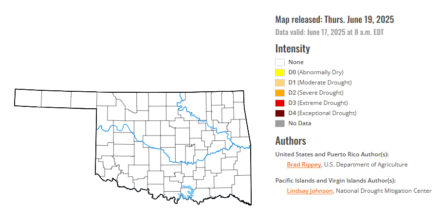
According to the latest Oklahoma drought monitor report, exceptional drought remains at zero percent, unchanged from the start of the calendar year.
Extreme drought or worse conditions remain at zero percent, unchanged since the week of October 29, 2024.
Severe drought or worse conditions remain at zero percent, unchanged since the week of May 29, 2025.
Moderate drought or worse conditions remain at zero percent, unchanged since the week of June 5.
Abnormally dry or worse conditions remain at zero percent, unchanged from last week.
According to the 6-to-10-day precipitation outlook map, most of Oklahoma, is leaning above 33-40% chance of precipitation through June 28. Only the western half of the panhandle is leaning above a 40-50 percent chance of precipitation.
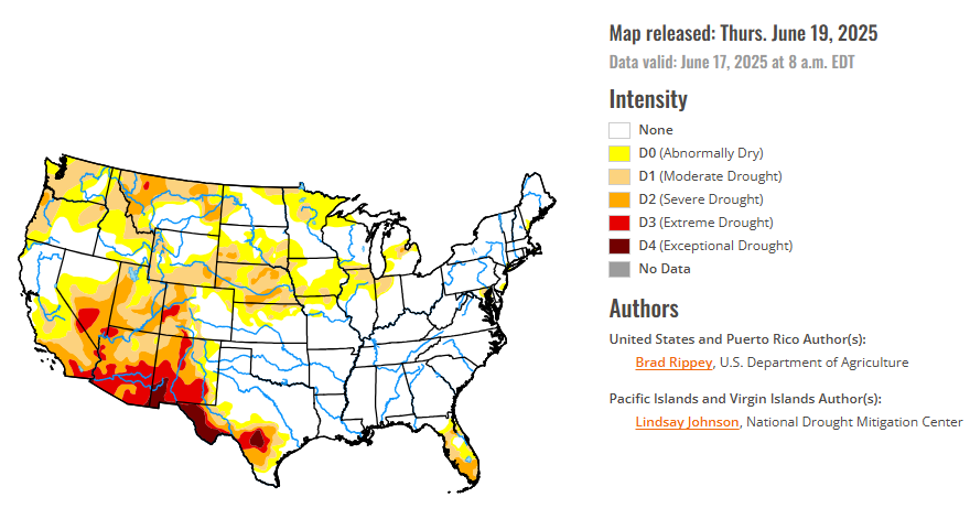
To view the United States Drought Map, CLICK HERE.
Active weather east of the Rockies led to significant reductions in drought coverage, especially in Florida, Texas, the northern and central Plains, and the upper Midwest. Amid early-summer showers, drought-free conditions largely continued from the southern Plains to the Atlantic Coast, excluding parts of Florida. Meanwhile, a Western hot spell—accompanied by short-term dryness across roughly the northern half of the region—was manifested in rapidly developing soil moisture shortages, declining prospects for summer water supplies, an elevated wildfire threat, a boost in irrigation demands, and increased stress on rain-fed crops.
In the Southern Plains, downpours in parts of Texas, the only state in the region still experiencing drought, delivered significant relief but also sparked flooding. In fact, deadly flash flooding struck the San Antonio area on June 12, when the official airport observation site received 6.11 inches—the second-wettest June day on record in that location, behind only 6.18 inches on June 3, 1951. San Antonio also set a one-hour station rainfall record for any time of year, with 3.98 inches falling from 3 to 4 am CDT. In drought-affected areas where heavier rain fell, some of the water was lost due to runoff, rather than absorption into parched soils. Additionally, groundwater and aquifer depletion in south-central Texas and neighboring areas has developed over many years—and will require much more than a singular heavy-rainfall event for replenishment.
In the High Plains, rain-related drought improvement dominated, although some significant drought-related agricultural problems persisted. By June 15, statewide topsoil moisture ratings on the High Plains ranged from 19% very short to short in Kansas to 50% in Wyoming, according to the U.S. Department of Agriculture. Wyoming led the region on that date with 36% of its rangeland and pastures rated in very poor to poor condition, followed by Nebraska at 30%. Elsewhere, significant rain bypassed a few areas, including northeastern North Dakota, where moderate drought (D1) expanded.
In the West, in contrast to areas east of the Rockies, mostly dry weather dominated during the drought-monitoring period. Rapid surface drying and prematurely melting (or melted) snowpack had led to a variety of agricultural and water-supply issues and concerns. The Northwest has been especially dry in recent weeks, with topsoil moisture—as reported by the U.S. Department of Agriculture on June 15—rated 65% very short to short in Montana, along with 56% in Oregon and 45% in Washington. Unlike Oregon and Washington, Montana received some much-needed precipitation in mid-June—but continued to experience agricultural drought impacts. For example, Montana’s rangeland and pastures were rated 46% in very poor to poor condition on June 15. Among major production states, Montana led the nation on that date in very poor to poor ratings for spring wheat (28% of the crop) and barley (25%). Meanwhile, among several early-season Northwestern wildfires was the 3,600-acre Rowena Fire near The Dalles, Oregon, which has destroyed more than 150 structures, including several dozen homes.
Looking ahead, active weather will shift eastward during the next couple of days, as a hotter, drier pattern envelops the nation’s mid-section and quickly expands. Additional rainfall could total 1 to 3 inches across the eastern one-third of the United States, with some of the highest amounts expected from the lower Great Lakes States into northern New England. However, by the end of the week, any significant precipitation should be limited to parts of the North, with hot, dry weather dominating the remainder of the country. During the weekend, high temperatures should top 100°F in the western Corn Belt as far north as South Dakota, while readings will reach 95°F in nearly all areas of the Midwest. By Sunday, however, cooler air should spread as far east as the northern High Plains. During the transition to cooler weather, showers will develop from the Pacific Northwest to Montana. In the East, the first major heat wave of the season will persist into the first half of next week, with high temperatures near 100°F expected at lower elevations of the Atlantic Coast States from Georgia to southern New England. There are some indications that, by early next week, remnant tropical moisture once associated with Eastern Pacific Hurricane Erick could be entrained by a cold front, leading to an increase in shower activity from the southern Rockies into the upper Midwest.
The NWS 6- to 10-day outlook for June 24-28 calls for the likelihood of above-normal temperatures across much of the eastern half of the country, as well as the northern Rockies and environs, while cooler-than-normal conditions will be mostly limited to the Southwest. Meanwhile, near- or above-normal rainfall can be expected nationwide, with an area stretching from the Southwest into the Great Lakes States having the greatest likelihood of experiencing wet weather.
.To view the 6-10 Day Precipitation Outlook Map, click here.
To view the 6-10 Day Temperature Outlook Map, click here.
To view the Monthly Drought Outlook Map, click here.


