

To view the latest Oklahoma drought map, CLICK HERE.
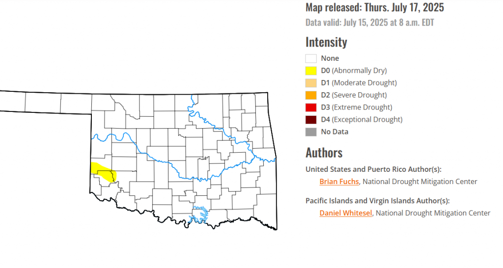
According to the latest Oklahoma drought monitor report, exceptional drought remains at zero percent, unchanged from the start of the calendar year.
Extreme drought or worse conditions remain at zero percent, unchanged since the week of October 29, 2024.
Severe drought or worse conditions remain at zero percent, unchanged since the week of May 29, 2025.
Moderate drought or worse conditions remain at zero percent, unchanged since last week.
Abnormally dry or worse conditions have persisted this week in parts of Greer county, Beckham county and Kiowa county.
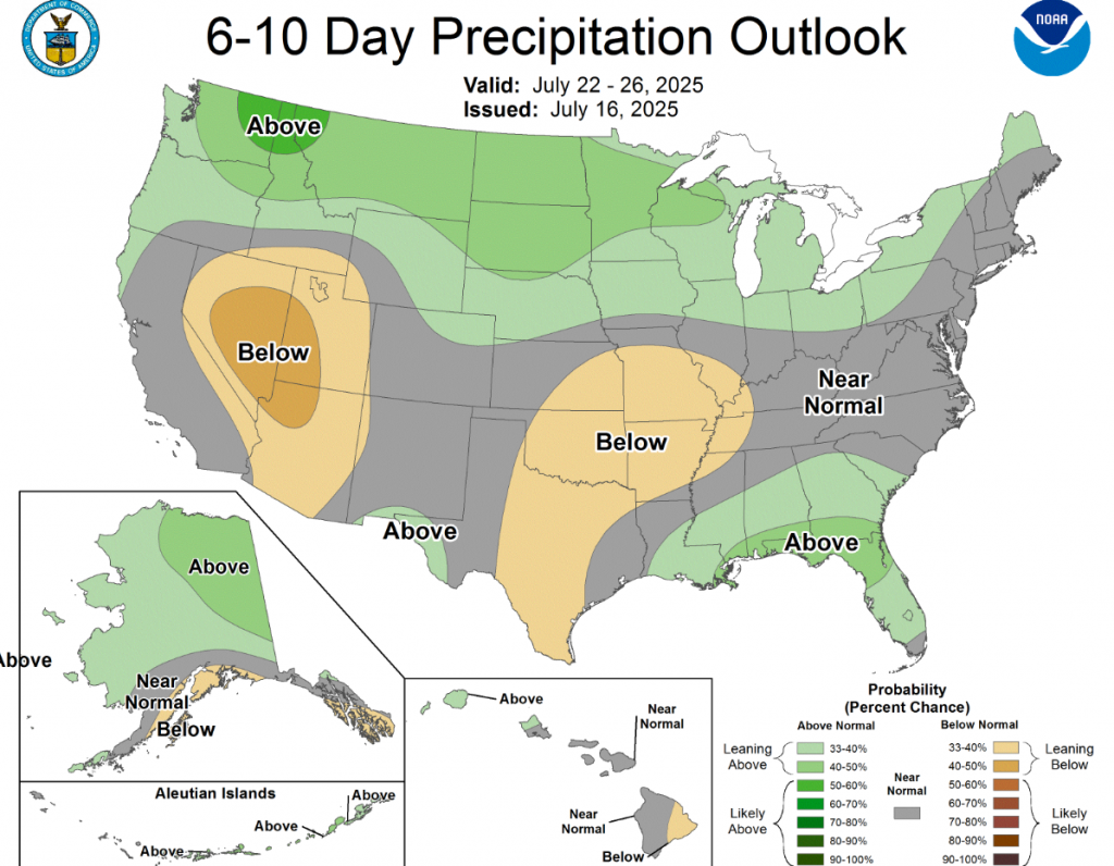
According to the 6-to-10-day precipitation outlook map, most of the state of Oklahoma is leaning below 33-40% chance of precipitation through July 26, while the panhandle is at near normal conditions through that same date.
To view the United States Drought Map, CLICK HERE.
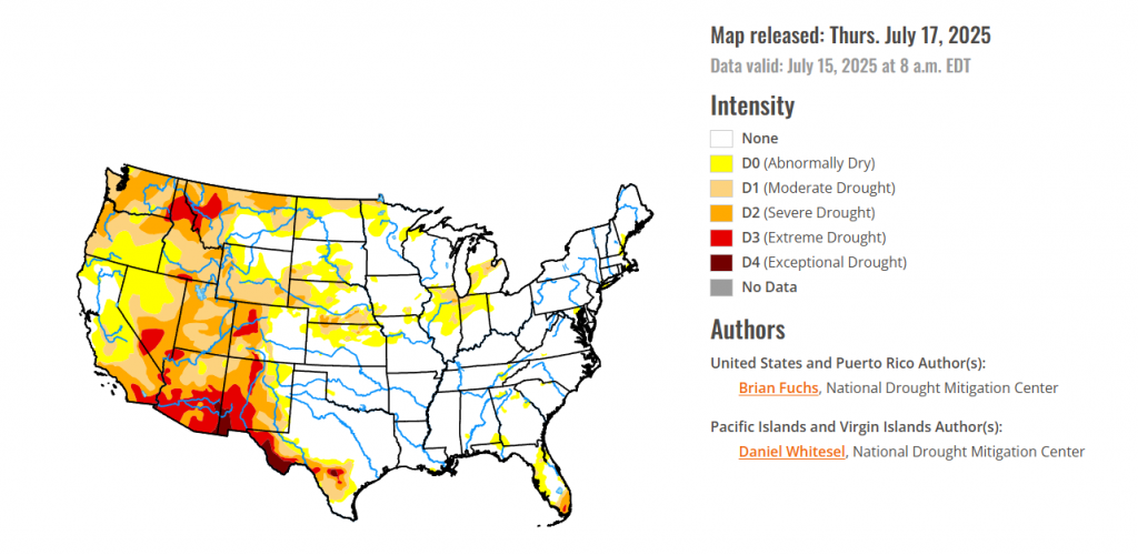
The last seven days was highlighted by dryness over much of the West, a continued active pattern bringing substantial rains to the southern Plains, and a wet week over much of the Mid-Atlantic and portions of the Midwest. Texas again stood out with several rain events that brought with them localized flooding. The long-term drought signal is still holding on in portions of southern Texas as recharge to depleted water systems has been slow, even with the rain in the region. Above-normal precipitation was recorded from eastern Nebraska through Illinois, bringing some much-needed rain to parts of northern Illinois. With the active rain pattern, temperatures over the southern Plains were 2-4 degrees below normal from Texas to Kansas and Nebraska while much of the West was 4-6 degrees above normal, with the greatest departures in Arizona and the Pacific Northwest. Warmer-than-normal temperatures dominated much of the eastern portions of the Midwest and the Northeast, where temperatures were 6-8 degrees above normal.
In Hawaii, moderate and severe drought improved on the northwest portion of the Big Island.
In Alaska, abnormally dry conditions expanded over the northern, western and middle portions of the state while moderate drought was improved slightly in the east.
No changes were made in Puerto Rico this week.
In the South, the wettest areas of the region were over central and eastern Texas as well as into portions of eastern Oklahoma and western Arkansas. Dry conditions were mostly over west and southern Texas and along the Oklahoma border in northern Texas. With the rain, temperatures were cooler than normal over much of Texas, with some areas of central Texas 3-5 degrees below normal for the week. Only eastern Arkansas and south Texas were at or above normal for the week. Abnormally dry conditions were improved over southwest Arkansas while much of central Texas had the drought intensities reduced due to the ongoing rains. Some areas of Texas recorded enough rain where a multiple category improvement was made.
For the High Plains, temperatures were mixed over the region with the northern and western areas 2-4 degrees above normal while the southern and eastern areas were 2-4 degrees below normal for the week. The wettest areas this week were in southwest Kansas, northeast Nebraska and portions of northeast Colorado, where over 200% of normal rain was recorded. Dryness continued in eastern Wyoming and in areas of the Dakotas as well as in northeastern Kansas. The wetter pattern over Nebraska over the past several weeks has allowed continued improvement to drought in the state. A full category improvement was made over most of central and northeast Nebraska and into portions of southern South Dakota. Moderate drought and abnormally dry conditions were improved over northeast Colorado while abnormally dry conditions expanded over northeast Kansas.
In The West, Temperatures for the week were warmer than normal over the region with departures of 4-6 degrees above normal. The only areas that were at or below normal were coastal areas of California and eastern New Mexico. Much of the area remained dry and there was only some spotty monsoonal moisture over the Southwest. Some areas of Montana did receive some needed rain, but conditions have been dry overall in that region. Degradation dominated the region for changes this week with no areas seeing improvements on the map. Severe and extreme drought were expanded over western Colorado while moderate drought and abnormally dry conditions were expanded over much of central Wyoming. In northern Utah, severe drought expanded while a new area of extreme drought was introduced. Much of the panhandle of Idaho and into central portions of the state had a full category degradation while severe and extreme drought expanded over western portions of Montana. Moderate and severe drought expanded over much of Washington and Oregon and severe drought expanded over northeast Nevada.
looking ahead Across the Midwest, The wettest areas of the region were from Iowa and into Illinois and Missouri where greater than 200% of normal rain fell this week. The driest areas were in northern Indiana into Ohio and portions of western Missouri, where less than 10% of normal rainfall occurred. Temperatures were at or above normal over most all the region with the eastern extent being the warmest with departures of 2-4 degrees above normal, while parts of western Iowa and southern Missouri were 2-4 degrees below normal. The areas that received the best rains also had improvements this week. In northern Illinois, abnormally dry to severe drought conditions were improved, while abnormally dry and moderate drought over much of eastern Iowa and portions of northwest Iowa also improved. In Minnesota, abnormally dry conditions were improved over the southwest and northern portion of the state with some improvements to moderate and severe drought in the far north. Abnormally dry conditions expanded over northern Indiana and into southwest Michigan, while moderate and severe drought were improved in the eastern areas of lower Michigan. Abnormal dryness and moderate drought improved over northeast Missouri and southern Wisconsin this week.
To view the 6-10 Day Precipitation Outlook Map, click here.
To view the 6-10 Day Temperature Outlook Map, click here.
To view the Monthly Drought Outlook Map, click here.


