To view the latest Oklahoma drought map, CLICK HERE.
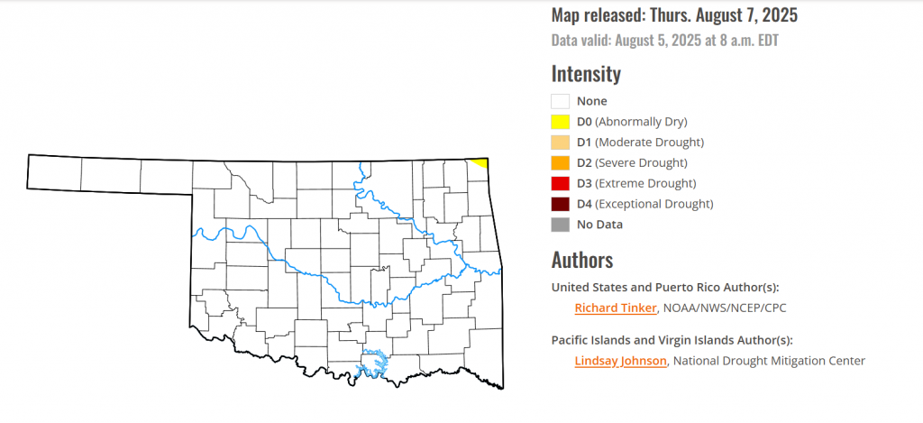
According to the latest Oklahoma drought monitor report, exceptional drought remains at zero percent, unchanged from the start of the calendar year.
Extreme drought or worse conditions remain at zero percent, unchanged since the week of October 29, 2024.
Severe drought or worse conditions remain at zero percent, unchanged since the week of May 29, 2025.
Moderate drought or worse conditions remain at zero percent, unchanged since last week.
Abnormally dry or worse conditions have emerged now in the very northeastern corner of Oklahoma in Ottawa County.
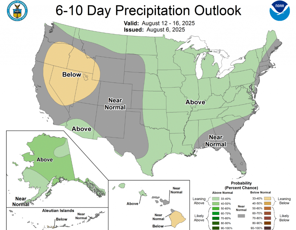
According to the 6-to-10-day precipitation outlook map, most of Oklahoma is leaning above 33-40% chance of rain through August 16, with western Oklahoma at near normal conditions through the same date.
To view the United States Drought Map, CLICK HERE.
It was a week with a lot of change noted in areas of dryness and drought across the U.S. Heavy to locally excessive rainfall engendered broad areas of improvement in much of the Southeast, the lower Great Lakes Region, the central and northern Great Plains, and many locations across the High Plains and adjacent southern Rockies. Meanwhile, continued subnormal precipitation and episodes of unusually hot weather, low humidity, and high winds led to large areas of deterioration in the central and northern Rockies. in the central and northern Rockies. Also, emerging short-term precipitation deficits led to the introduction of scattered areas of abnormal dryness (D0) over parts of the Middle and Lower Mississippi Valley, the Tennessee Valley, and near the western foothills of the western Appalachians. A few spots of deterioration were also introduced in western portions of the Southeast (where typical summer shower and thunderstorm activity has been less robust than usual) and Southwest (where subnormal monsoonal rains have been observed).
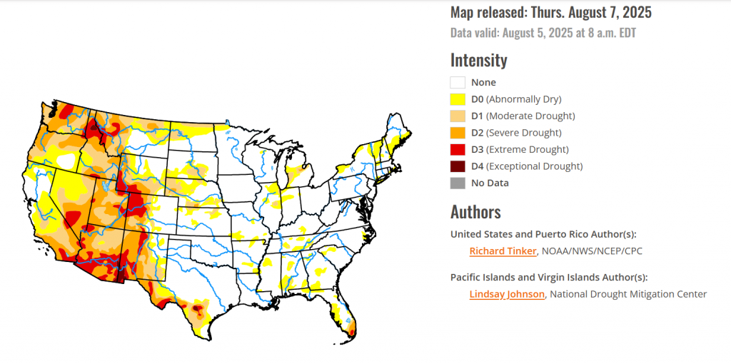
For the Hawaiian Islands, fairly typical dry summertime conditions prevailed across the islands, with some rainfall observed in windward areas. As a result, conditions remained generally unchanged except in parts of the southeastern Big Island, where D0 areas intensified into moderate drought (D1).
In Alaska, anomalously warm and dry weather has continued across the North Slope, where abnormal dryness (D0) expanded considerably. Further south, due to scattered showers and somewhat lower temperatures and higher humidity than in most recent weeks, a few areas of D0 were removed, specifically in the Koyukuk River area and the central Interior.
In Puerto Rico, locally heavy tropical showers brought an end to abnormal dryness (D0) in some areas near the southwest coastline, but nondescript conditions elsewhere allowed the scattered patches of D0 to persist.
In the south, outside southern and western Texas, not much dryness or drought has been observed across the South Region. But after a few relatively dry weeks, short-term precipitation shortfalls have developed in portions of Arkansas and Tennessee, leading to the introduction of a few patches of abnormal dryness (D0) in areas of significant 30-day rainfall shortages and near-to-below-normal 60-day totals. A much larger proportion of these two states report 30-day precipitation deficits, but above-normal 60-day totals precluded more expansive D0 development this week, although the situation will need to be monitored going forward. In Tennessee, some patches of abnormal dryness and isolated moderate drought (D0 and D1) was assessed last week. In the easternmost parts of the state, heavy rains engendered a bit of improvement, but the burgeoning dryness farther west allowed a few additional spots of moderate drought to develop. To the west, rainfall was sufficient to end the fledgling area of abnormal dryness in southwestern Oklahoma, but more widespread and intense drought continued to cover large parts of western and southern Texas. Moderate to heavy rainfall was observed over parts of the drought-affected region, leading to some improvement in the Big Bend and along the northern fringe of the region. Substantial rainfall evaded areas farther to the south, however, allowing for some expansion of D0 and D1 conditions in the southernmost parts of the state. Since early May, rainfall totals exceed 3 inches in portions of south-central Texas, and approach 6 inches in part of the Big Bend. Despite recent improvement in much of the state, however, a small patch of exceptional drought (D4) persisted in upper South Texas, and severe drought continued in adjacent areas as well as parts of the Rio Grande Valley and Big Bend. But despite recent drought improvement, 22 percent of the Texas cotton crop and 48 percent of its oat crop was in poor to very poor conditions, according to USDA.
For the High Plains, Rainfall varied in intensity across the High Plains Region, with abundant rainfall amounts falling on a large part of the Plains while lesser, subnormal totals were observed in the higher elevations farther west. A similar pattern has been observed periodically for several weeks now, resulting in significantly worse conditions in the western part of the region than farther east. A solid swath of moderate drought (D1) or worse covers most of southern and western Wyoming and the western half of Colorado, with severe drought (D2) covering a large part of this region, and extreme drought (D3) noted in a sizeable portion of west-central and northwestern Colorado. This represents a significant increase in the extend of D2 and D3 coverage compared to last week. In contrast, another wet week led to a continued reduction in the coverage of the abnormal dryness (D0) to locally severe drought (D2) over the Great Plains. A broken pattern of heavy rainfall – with upwards of 3 inches reported in spots – prevailed from northern Kansas through much of the Dakotas, although higher amounts were more common in some areas than others. The improvements left severe drought confined to part of south-central Nebraska and adjacent Kansas, southwestern Nebraska, and a small area in south-central South Dakota. Moderate drought (D1) coverage also decreased, mainly across Nebraska and a few adjacent locations in the far eastern sections of Colorado and Wyoming. The USDA reported short or very short subsoil moisture across about one-third of Colorado and two-thirds of Wyoming. In addition, 17 percent of the Colorado corn crop was in poor or very poor condition, and drier weather earlier in the summer has left one-third of the Nebraska oat crop in poor or very poor condition.
In the West, Heavy precipitation prompted significant areas of improvement across the southeastern and northern sections of the West Region, but hot and dry weather has caused dryness and drought to intensify in central parts of the Region, across Utah, eastern Nevada, and northeastern Arizona (similar to the situation in western parts of Colorado and Wyoming). Reports of 2 or more inches of rain were fairly common across southeastern and north-central through northwestern Montana as well as northeastern New Mexico, with lesser amounts in other parts of these states. These rains brought 2-week totals to between 2 and 5 inches in much of New Mexico and Montana, with locally higher totals, especially in north-central Montana and northeastern New Mexico. This prompted broad improvements through both states, but even so, areas that missed most of the rain in these states remained entrenched in drought. Exceptional drought (D4) persisted in part of southwestern New Mexico, and extreme drought (D3) remained across north-central and southwestern parts of the state, along with a significant swath of west-central Montana. Moderate to severe drought still affected a large part of the remainders of these states despite improvements, and only the southeastern quarter of Montana and northeastern New Mexico have completely emerged from any designation of dryness or drought. Farther west, showery weather has occurred periodically for the past few weeks in central and eastern Oregon, leading to a reduction in the coverage of dryness and drought there. Across central parts of the West Region from eastern Nevada through Utah, rainfall has been far less generous, and drought either persisted or deteriorated here. The entire region is experiencing at least moderate drought at this point, with widespread D2 conditions across eastern and western Utah, and adjacent Nevada. Some expansion of extreme drought (D3) occurred in east-central and northeastern Utah, where conditions have been similar to those observed across western parts of Colorado and Wyoming. Elsewhere, no changes were observed, and broad areas of drought remained entrenched. USDA reports that 50 percent of the Barley crop and 48 percent of the spring wheat crop in Washington was in poor or very poor condition, as were 26 percent of the barley crop and 47 percent of spring wheat in Montana. In addition, 90 percent of Nevada rangeland was in poor or very poor condition.
looking ahead Across the Midwest, Substantial but spotty rainfall led to a mixed bag of changes in the Midwest region. Increasing 30- and 60-day rainfall deficits prompted the introduction of abnormal dryness (D0) in part of south-central Kentucky, where conditions are similar to those observed across Arkansas and Tennessee. Well to the north, deteriorating conditions were also noted in a few spots across the Lower Peninsula of Michigan. In much of the central and southwestern Lower Peninsula, rainfall shortages date back at least 6 months, with deficits of 4 to locally 8 inches recorded since early February in portions of the affected region. More recently, shorter-term deficits have slowly increased there, leading to a bit of expansion of severe drought (D2) conditions in east-central locations, and some increase in D0 and D1 coverage farther west close to Lake Michigan. In contrast, central portions of the Midwest Region have received significant rainfall during the past 1-2 weeks, leading to some improvement in the dryness and drought that extended from extreme west-central Ohio westward over parts of northern Indiana and northeastern Illinois. Dryness was eradicated in much of east-central Indiana, and the coverage of D0 and D1 declined elsewhere in this swath, particularly near southwestern Lake Michigan. Some moderate drought also persisted in east-central Illinois, with a small area of D0 expansion brought in just to the east, and area which has missed much of the recent rainfall. Along the western tier of the Midwest Region, increasing short-term rainfall deficits were noted over the southern half of Missouri, similar to the situation across Arkansas and much of Tennessee. Some areas of abnormal dryness (D0) emerged this week in locations where 60-day or longer-term precipitation was a bit below normal. From northern Missouri northward, very little dryness and drought was present, and there is even less coverage this week. Recent rainfall brought an end to the small area of abnormal dryness (D0) in southern Iowa, and nondescript conditions kept D0 and D1 unchanged in extreme northwestern Minnesota.
To view the 6-10 Day Precipitation Outlook Map, click here.
To view the 6-10 Day Temperature Outlook Map, click here.
To view the Monthly Drought Outlook Map, click here.