

To view the latest Oklahoma drought map, CLICK HERE.
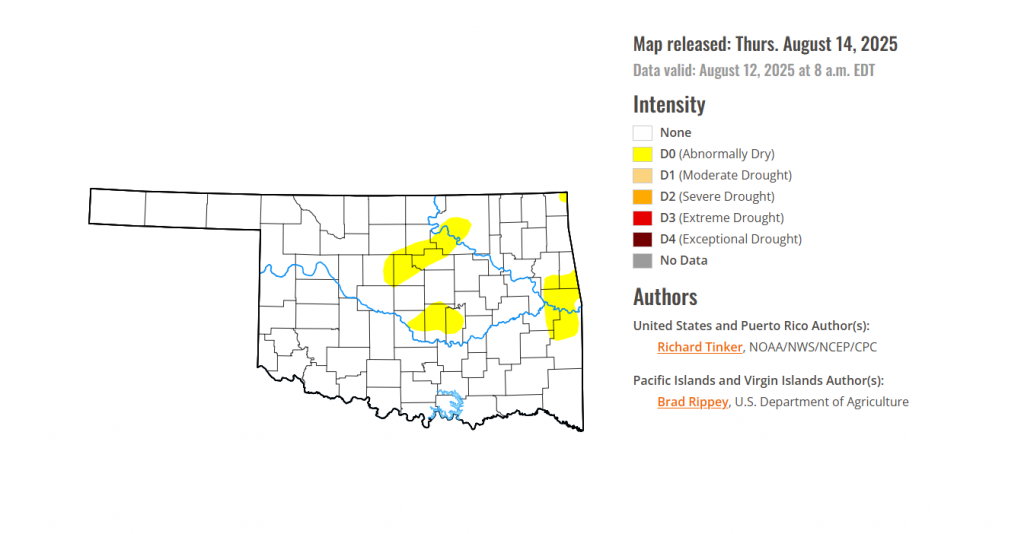
According to the latest Oklahoma drought monitor report, exceptional drought remains at zero percent, unchanged from the start of the calendar year.
Extreme drought or worse conditions remain at zero percent, unchanged since the week of October 29, 2024.
Severe drought or worse conditions remain at zero percent, unchanged since the week of May 29, 2025.
Moderate drought or worse conditions remain at zero percent, unchanged since last week.
Abnormally dry or worse conditions have spread into the central and eastern parts of Oklahoma this week.
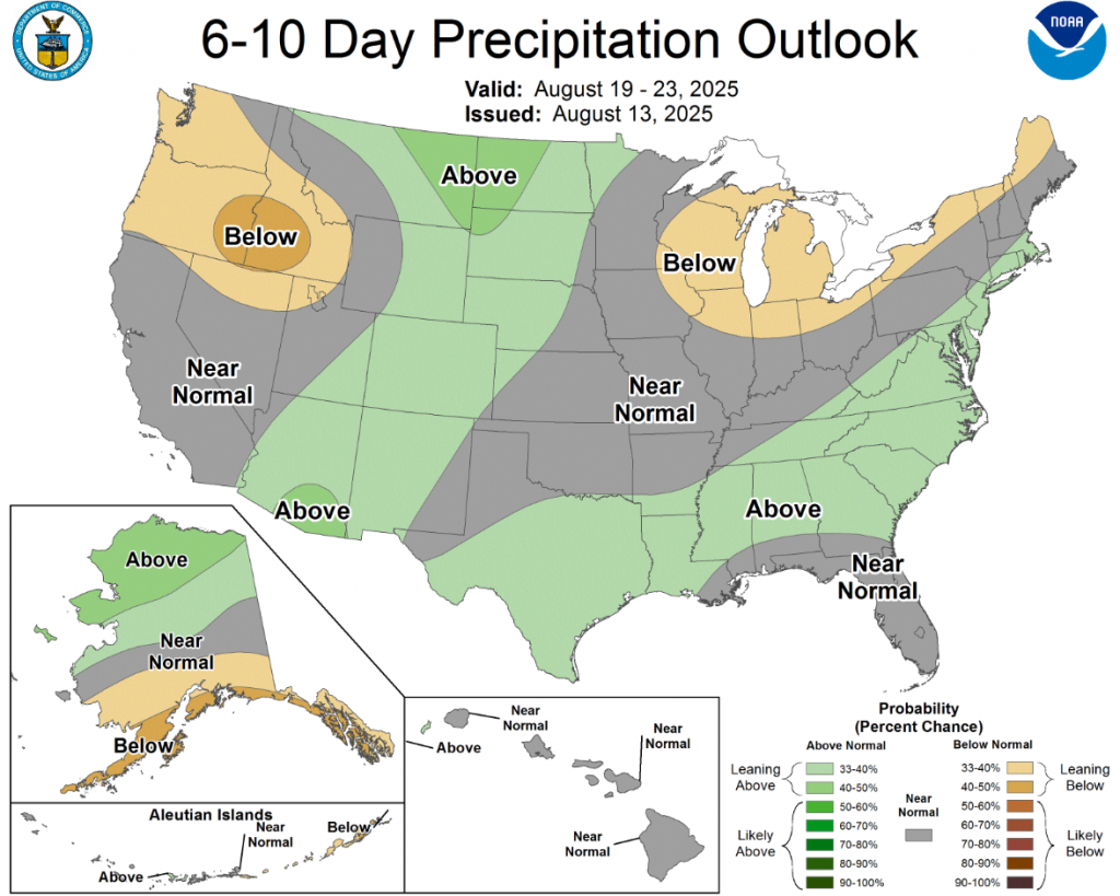
According to the 6-to-10-day precipitation outlook map, Oklahoma is experiencing near-normal conditions, with small parts of southeastern Oklahoma leaning above a 33-40% chance of rain through August 23.
To view the United States Drought Map, CLICK HERE.
Intensifying short-term rainfall shortages led to expanding and intensifying dryness and drought over much of the Lower Mississippi Valley, Ohio Valley, Tennessee Valley, Northeast, and parts of the Deep South, southern Plains, central Arizona, and the central Rockies. Meanwhile, a second consecutive week with moderate to heavy precipitation led to areas of improvement in the South Atlantic States from the Carolinas through Florida, across northern reaches of the Rockies and Plains, and over parts of the central Great Plains. The heaviest amounts (8 to 11 inches) doused areas in southeast Wisconsin from central Washington and Ozaukee Counties southward through much of north and central Waukesha and Milwaukee Counties. Meanwhile, 6 to 8 inches were dropped on a broader section of southeast Wisconsin as well as a few patches across southeast South Dakota, the Carolinas Piedmont and adjacent southern Appalachians, the coastal Carolinas, north-central Florida, the central Florida Peninsula, and interior southeast Florida.
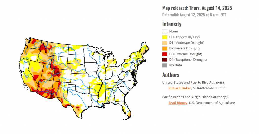
For the Hawaiian Islands, Fairly typical summertime conditions prevailed across the islands, with some rainfall observed in windward areas. As a result, conditions remained generally unchanged except in parts of southern and northeastern Oahu (including Honolulu) where conditions deteriorated from abnormal dryness (D0) into moderate drought (D1). Currently, scattered areas of D0 and D1 exist in the northwestern half of the state while more severe dryness covers most areas to the south and east, with broad areas topping out at D3 in northern interior parts of the Big Island.
In Alaska, western Alaska experienced significant rainfall, which led to a reduction in D0 coverage there. In southcentral parts of the state, D0 was eliminated in a heavily-populated part of the Anchorage area. Meanwhile, based primarily on 3-month precipitation percentiles, there was a bit of a reconfiguration in the pattern of D0 coverage across the northeast Interior. The fire weather build-up index (BUI) is significantly elevated over the Yukon Flats, so the D0 there is unchanged. Unremarkable conditions on the North Slope and southeast Interior kept D0 there intact as well.
In Puerto Rico, Heavy rainfall affected portions of western Puerto Rico and scattered areas farther east, sufficient to alleviate D0 conditions along some of the southwest coastal areas, plus portions of the eastern and south-central sections of the Commonwealth, including portions of the San Juan metro area. Meanwhile, precipitation deficits continue to build in the southeastern and interior east-central areas. Moderate drought (D1) was introduced in Salinas, Guayama, and eastern Coamo Municipalities, and abnormal dryness (D0) was introduced in several municipalities to the north and northwest.
In the south, Patches of moderate to heavy rain were observed over southernmost Louisiana and adjacent Texas, much of the Red River (south) Valley, the southern Texas Panhandle, and the northern tier of Oklahoma. Other areas saw scattered to isolated showers that did not markedly improve any extant dryness. Similar to conditions in adjacent Mississippi, above-normal precipitation earlier in the summer ebbed beginning in early July, and significant short-term rainfall deficits have accumulated over the past several weeks although multi-month precipitation totals are generally near or above normal. In conjunction with hot summertime conditions, this has led to quickly-depleting surface moisture over much of Tennessee, Arkansas, and portions of Louisiana. As a result, D0 conditions have been introduced and expanded rapidly. Farther west, less widespread short-term moisture deficits led to several patches of new D0 this week in western Arkansas, Oklahoma, and northeastern Texas. Farther south and west, some D0 and D1 expansion was noted in Deep South Texas, but dryness and drought were essentially unchanged across New Mexico and the remainder of Texas. USDA indicated that short or very short topsoil moisture covered 60 percent of Tennessee and 80 percent of Arkansas (up from 18 and 39 percent, respectively, in early July). The proportion of the Tennessee cotton crop in poor or very poor condition increased from 12 percent in early July to 26 percent last week.
For the High Plains, Rainfall varied in intensity across the High Plains Region once again this week, with abundant rainfall amounts falling on much of North Dakota, southern Nebraska, and some spots in Kansas leading to improved conditions. Some improvement was also noted in part of the southeast Wyoming High Plains. Meanwhile, less precipitation kept dryness and drought approximately unchanged across South Dakota, and allowed for areas of intensification for the second consecutive week in central and western parts of Colorado and Wyoming. A sizeable swath of northwestern Colorado deteriorated into exceptional drought (D4), and D2 to D3 conditions expanded in other areas over and near the higher elevations in western parts of the High Plains Region. Since early July, USDA indicated that the proportion of topsoils short or very short of moisture increased from 20 to 32 percent in Colorado, and from 52 to 63 percent of Wyoming. In Colorado, 19 percent of the corn crop is in poor or very poor condition (up from just 1 percent in early July) while in Nebraska, one-third of the oat crop is in poor or very poor condition (up from 5 percent in early July).
In the West, Heavy precipitation (one to locally multiple inches in most areas) prompted significant areas of improvement across northern and part of western Montana as well as portions of northern Idaho. Farther south, a few weeks of deficient monsoonal rainfall and above-normal temperatures prompted deterioration in D1 to D3 conditions across southwestern Montana, several swaths across Utah, and a few areas in Arizona and eastern Nebraska. In addition, conditions deteriorated from moderate to severe drought (D1 to D2) in part of northwestern Washington. In other parts of the West Region, dryness and drought was unchanged compared to last week. Outside the northern tier of the Region, very little precipitation was reported outside several tenths to about an inch in southeastern Arizona. The proportion of rangelands in poor or very poor condition increased in the last 5 weeks from 32 to 49 percent in Utah, from 22 to 44 percent in Washington, and from 10 to 34 percent in Idaho. Over half of the Washington spring wheat crop is in poor or very poor condition compared to just 17 percent in early July. During this period, the proportion of Montana spring wheat in poor or very poor condition increased from 37 to 47 percent. USDA also indicated that 53 percent of the Washington barley crop is in poor or very poor condition, compared to just 14 percent in early July.
looking ahead Across the Midwest, Conditions varied substantially across the Region last week. Heavy rains doused much of Iowa and significant parts of Minnesota, Wisconsin, and the Upper Peninsula of Michigan last week. A few inches to nearly one foot of rain pounded much of the southern tier of Wisconsin and several swaths in other parts of these areas. Meanwhile, more-scattered moderate to locally heavy amounts were observed in other parts of Wisconsin and Minnesota as well as portions of the western Lower Peninsula of Michigan, the northern and western parts of Missouri, and northwestern Illinois. In contrast, rainfall was light and patchy to isolated at best farther east, including most of Kentucky, Indiana, and Ohio. Much of the heaviest rain fell on areas already out of dryness and drought, so improvement was limited to parts of northern Minnesota and northwestern Illinois while persisting or increasing dryness was more common farther south and east, especially over southern Missouri and adjacent areas, plus portions of the eastern and southern Great Lakes region. USDA indicated that the proportion of Michigan covered by short or very short topsoil moisture increased from 21 to 52 percent over the last 5 weeks.
To view the 6-10 Day Precipitation Outlook Map, click here.
To view the 6-10 Day Temperature Outlook Map, click here.
To view the Monthly Drought Outlook Map, click here.


