

To view the latest Oklahoma drought map, CLICK HERE.
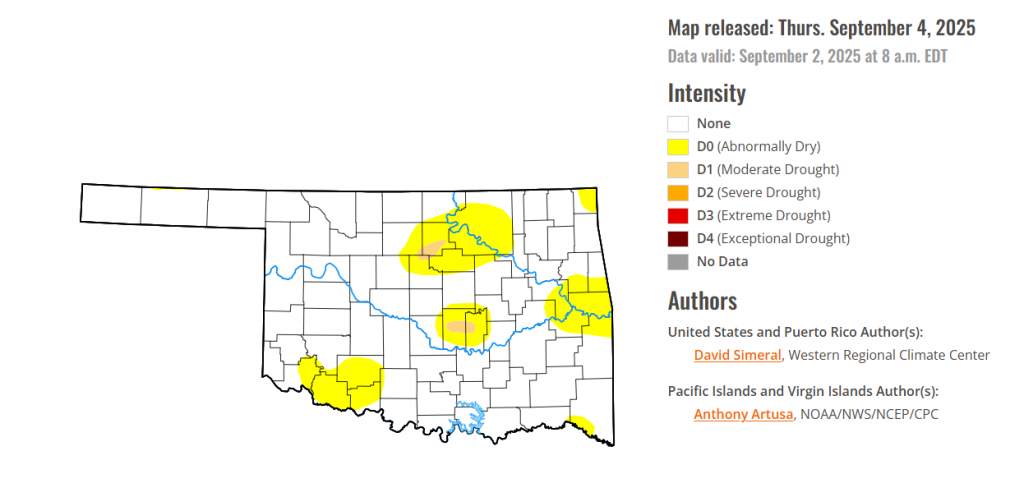
According to the latest Oklahoma Drought Monitor report, exceptional drought remains at 0 percent, unchanged from the start of the calendar year.
Extreme drought or worse conditions remain at zero percent, unchanged since the week of October 29, 2024.
Severe drought or worse conditions remain at zero percent, unchanged since the week of May 29, 2025.
Moderate Drought or worse conditions have remained in Noble County and Pottawatomie County.
Abnormally dry or worse conditions have spread in southeastern Oklahoma.
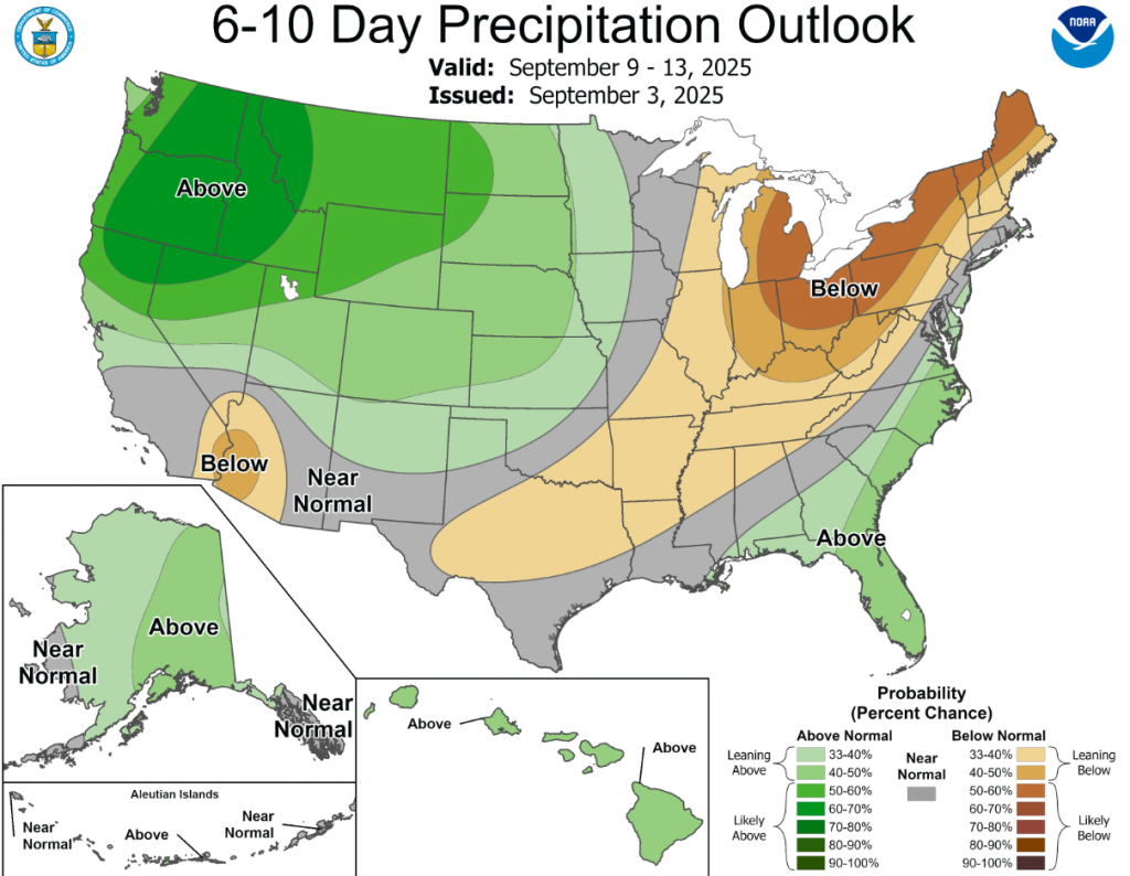
According to the 6-to-10-day precipitation outlook map, Northwestern Oklahoma is leaning above 33-40% chance of precipitation, southeastern Oklahoma is leaning below 33-40% chance of rain, while central Oklahoma has near normal conditions.
To view the United States Drought Map, CLICK HERE.
This U.S. Drought Monitor (USDM) week saw widespread degradation in drought-related conditions across areas of the Midwest, Mid-Atlantic, and Northeast where precipitation during the past 30-day period has been below normal. In these areas, rainfall deficits ranged from 3 to 5 inches with the largest deficits observed across areas of New England and Lower Midwest. Elsewhere, short-term dryness and drought impact reports from the agricultural sector led to degradations in isolated areas of the Southeast and South. For the week, most of the eastern half of the conterminous U.S. experienced unseasonably cooler temperatures, while temperatures out West were above normal, especially across the Pacific Northwest and Desert Southwest. In the West, conditions were generally dry, however, some isolated monsoon thunderstorm activity was observed in the Southwest, Sierra Nevada Range of California, Great Basin, and in the Rocky Mountains. In the Pacific Northwest, continued dryness as well as declining streamflow and soil moisture levels led to expansion of areas of exceptional drought in the Idaho Panhandle. In terms of reservoir storage in the West, California’s reservoirs continue to be at or above historical averages for the date (September 2), with the state’s two largest reservoirs, Lake Shasta and Lake Oroville, at 104% and 112% of average, respectively. In the Southwest, the U.S. Bureau of Reclamation is reporting (September 1) Lake Powell at 29% full (44% of average for the date), Lake Mead at 31% full (52%), and the total Colorado system (September 1) at 38% of capacity (compared to 44% of capacity the same time last year).
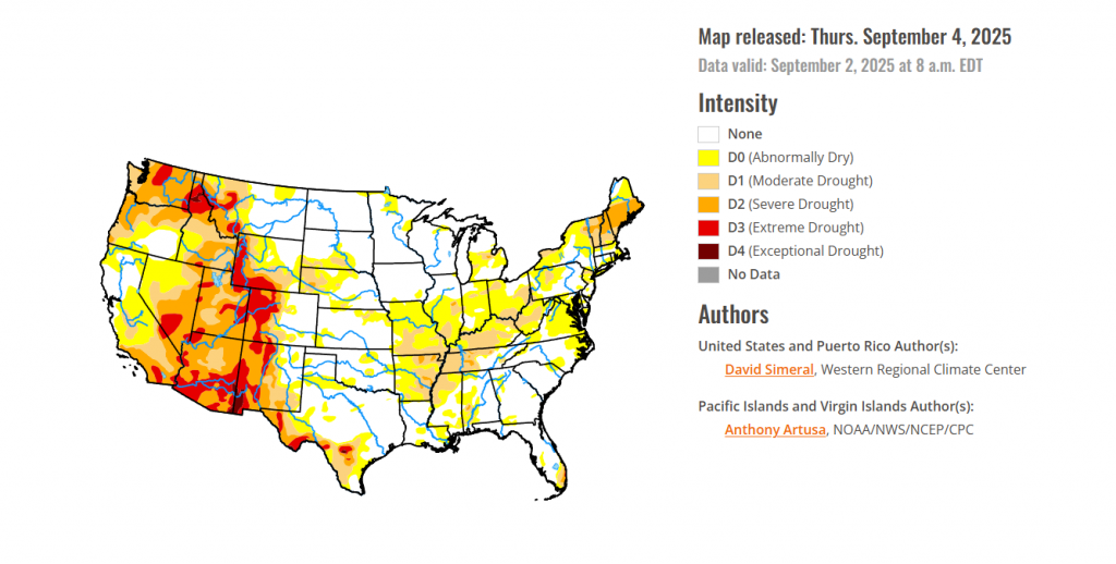
In the southern plains, On this week’s map, improvements were made in eastern Texas, northern Louisiana, northern Arkansas, and central Oklahoma in response to locally heavy rainfall (ranging from 2 to 6+ inches) observed during the past week. Elsewhere, short-term dryness led to introduction of areas of Abnormally Dry (D0) in areas of Texas including the Panhandle and Edwards Plateau. In Tennessee, degradations were made on the map in central and western portions in response to precipitation shortfalls (1 to 4 inches) during the past 30-day period. In terms of hydrologic conditions in Texas, the state’s reservoirs (cumulatively) were 77% full with many in the eastern part of the state in good condition (over 90% full), while numerous others in the western portion of the state continue to experience below-normal levels, according to Water Data for Texas (September 3). For the week, average temperatures were below normal (2 to 8 degrees F) across most of the region with the exception of southern and western portions of Texas where temperatures were 1 to 5 degrees above normal.
In the High Plains, On this week’s map, improvements were made in the region, namely in northern Kansas, and southern Nebraska, where some isolated shower activity (1 to 5+ inches) during the past week continued to help chip away at the longer-term precipitation deficits. For the past 60-day period, the Lincoln AP observed its 6th wettest on record with 10.24 inches (+3.69 departure from normal), according to the SERCC. Conversely, conditions deteriorated on the map in the southwestern extent of South Dakota where a combination of short and long-term precipitation deficits have persisted leading to expansion of areas of Moderate Drought (D1). For the week, above-normal temperatures (ranging from 2 to 10 degrees F) were logged across northern North Dakota, while much of the remainder of the region experienced below normal temperatures (ranging from 1 to 10 degrees F), especially in the southern extent of the entire region.
In the West, Out West, some isolated monsoon shower activity was observed across areas of the Desert Southwest, Sierra Nevada, and Great Basin as well as areas of the central and northern Rockies. Improvements were made on the map in Colorado, western Montana, southern Idaho, northern Utah, and southeastern California, while some degradations were made in north-central Arizona where monsoon-season precipitation has been below normal. According to the National Weather Service in Tucson, 2025 monsoon rainfall has been below normal across much of the state including Flagstaff, Phoenix, and Tucson. Conversely, a more active monsoon season has affected areas of New Mexico including southern and eastern portions of the state. For the week, average temperatures were below normal across areas of eastern California, central Great Basin, and areas of the Intermountain West including Utah, Colorado, and southern Wyoming where temperatures were 5 to 10 degrees below normal. In the Pacific Northwest, temperatures were above normal with anomalies ranging from 2 to 15 degrees F and the greatest departures observed in eastern Washington, Idaho Panhandle, and northwestern Montana.
Looking Ahead, The NWS Weather Prediction Center (WPC) 7-Day Quantitative Precipitation Forecast (QPF) calls for moderate to heavy precipitation accumulations across areas of the Desert Southwest (southeastern Arizona) in association with remnant moisture from Hurricane Lorena. Additionally, heavy rainfall is expected in southern Florida, while light-to-moderate accumulations are expected across areas of the Pacific Northwest, Rockies, Texas, Lower Midwest, and Northeast. The Climate Prediction Center (CPC) 6-10-day outlooks call for a moderate-to-high probability of above-normal temperatures across most of the West, Central and Northern Plains, and Gulf Coast region. Conversely, below-normal temperatures are forecasted for the Midwest, Mid-Atlantic, Northeast, and areas of eastern California and western Great Basin. In terms of precipitation, there is a low-to-moderate probability of above-normal precipitation across most of the conterminous U.S. with exception of areas of the Southwest, Upper Midwest, and New England in proximity to the Great Lakes and Canadian border where below-normal precipitation is expected.
o view the 6-10 Day Precipitation Outlook Map, click here.
To view the 6-10 Day Temperature Outlook Map, click here.
To view the Monthly Drought Outlook Map, click here.


