

To view the latest Oklahoma drought map, CLICK HERE.
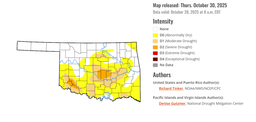
According to the latest Oklahoma Drought Monitor report, exceptional drought remains at 0 percent, unchanged from the start of the calendar year.
Severe Drought: Severe drought (D2) still remains in parts of central and southwestern Oklahoma, but severe drought present last week in Payne County has withdrawn this week. D2 severe drought now covering 3.48% of the state.
Widespread Dryness: Over 56 percent of the state is now experiencing abnormally dry to drought conditions versaus over 72 percent last week.
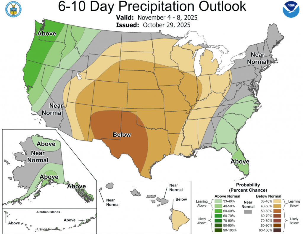
According to the 6-to-10-day precipitation outlook map, a large majority of the state is leaning below 40-50% chance of rain through November 8, with far Southwestern Oklahoma leaning below 50-60% chance through that same date.
To view the United States Drought Map, CLICK HERE.
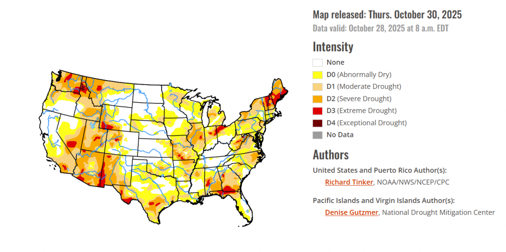
Heavy precipitation (over 3 inches) was observed last week over many of the higher elevations and coastal areas from northern California to the Canadian Border. Farther east, similar amounts doused numerous locations from Oklahoma southward to central Texas, a few areas across the lower Mississippi Valley, portions of the southern Appalachians, parts of the central Gulf Coast, the east-central Florida Peninsula, and some areas just downwind of Lake Erie. Between 5 and 10 inches of precipitation fell on a few areas in the coastal and higher elevations of Washington and Oregon, north-central through east-central Oklahoma, northeastern Texas, south-central Mississippi, and east-central Florida. Moderate to heavy precipitation (between 1 and 3 inches with isolated higher amounts) was reported across the rest of the Pacific Northwest, parts of the higher elevations in the northern Intermountain West, part of the northern Great Plains, most of central and western Michigan, a few patches across New England, and many areas from the central Carolinas to the central Great Plains, plus much of northern and central Texas, the southern Lower Mississippi Valley, and a few patches across northwestern and central Florida. Other locations across the Conterminous U.S. (“Lower-48”) received only a few tenths of an inch at best. This resulted in significant areas of improvement in the Pacific Northwest, northern Intermountain West, the Great Plains from eastern Kansas through central Texas, the interior Deep South, the Ohio Valley, the eastern Great Lakes, the Carolinas, the southern Appalachians, and a few patches in New England. In some of the drier areas, dryness and drought conditions deteriorated in a few parts of the central and northern High Plains, the Texas Panhandle, Deep South and Coastal Texas, southern Alabama and Georgia, and small areas in the mid-Atlantic, and the Northeast from New York to coastal Maine. Deteriorating conditions also affected small parts of Hawaii (Upcountry Maui, northeastern Maui, and the southeastern Big Island). Conditions in Puerto Rico were unchanged with abnormal dryness persisting in parts of southeastern Puerto Rico, and Alaska remained free of any dryness or drought.
In the southern plains, Heavy rains in many regions engendered broad areas of improvement across most of Texas, Oklahoma, Louisiana, Mississippi, and Tennessee. Some areas of deterioration were observed in areas that missed the heavy rains, specifically southern and coastal Texas, part of the Texas Panhandle, and a few patches of the Red River (South) Valley. Several inches of rain resulted in a few swaths of 2-category improvement across central and east-central Texas as well as central Oklahoma, where upwards of 4 to 8 inches of precipitation were observed. Overall, coverage of dryness and drought dropped from 80.6 to 68.6 percent of the Region while drought coverage (D1 or worse) was reduced from 37.1 to 27.6 percent. D3-D4 extent inched down slightly from 10.7 to 9.6 percent. But despite the wet week, 90-day rainfall amounts ranged from 3 to 6 inches below normal across much of the Red River (South) Valley, and from 4 to locally over 10 inches from central Texas eastward along and near the Gulf Coast.
In the High Plains, The High Plains Region is currently the Region least-affected by dryness and drought. Only 37.2 percent of the Region is affected by dryness (D0) or drought (D1-D4). Colorado and Wyoming are the most drought-impacted states, with almost 55% of those states combined covered by D0 conditions or worse, and about one-third experiencing some degree of drought (D1-D4), primarily in the higher elevations. In the Great Plains states, there is no drought in North Dakota and D0 covers less than 3 percent of the state. Dry conditions are a little more common farther south, with D0 or worse covering 39 percent of South Dakota, 35 percent of Nebraska, and 25 percent of Kansas. In all 3 states, drought (D1 or worse) coverage is less than 13 percent. Last week, moderate to locally heavy rain induced areas of improvement in eastern Kansas and far northwestern Wyoming while patches of deterioration were introduced in eastern South Dakota and small parts of south-central Colorado and far northeastern Kansas.
In the Midwest, Several inches of precipitation fell to the lee of Lake Erie, leading to a swath of 2-category improvement in northeastern Ohio. Moderate to heavy precipitation was reported across northern Upper Michigan, western Lower Michigan, northwestern Minnesota, southeastern Missouri, and areas near the Mississippi/Ohio Rivers’ Confluence. Other locations across Michigan, northern Minnesota, and southern half of Missouri, and central through southern Kentucky observed light to locally heavy totals while most areas from southern Minnesota, Iowa, and northern Missouri eastward across Illinois, Indiana, and Ohio experienced a dry week, with only isolated sites reporting up to 0.2 inch. Some of the wetter locations across Michigan and in the Ohio Valley felt improved conditions by the end of the week, and a few other patches of improvement were introduced based on a re-assessment of heavy rains earlier in the month. Deterioration was introduced across portions of the dry swath from Iowa into Indiana. Overall, coverage of D0 or worse declined slightly from 71.2 to 68.8 percent of the Midwest Region, but the more intense conditions (D2 or worse) expanded slightly from 9.7 to 11.6 percent of the Region. Precipitation over the past 60 days was broadly 3 to 5 inches below normal in northern Wisconsin, part of northern and eastern Iowa, central and northern Illinois, and numerous locations across central Indiana and northwestern Ohio.
To view the 6-10 Day Precipitation Outlook Map, click here.
To view the 6-10 Day Temperature Outlook Map, click here.
To view the Monthly Drought Outlook Map, click here.


