


Statewide Discussion: No critical fire weather or significant fire potential is anticipated throughout the week. Recent
rainfall provided wetting rainfall over most of Oklahoma serving to improve composite fuel moisture and spur limited
green-up in some areas where cool-season species are prevalent. Although dry weather in the last five to nine days plus
some pockets where recent freezing temperatures have occurred
highlight the transition toward seasonal dormancy, increasing ratio of
available fuels and potential for more frequent wildfire occurrence. The
Oklahoma Drought Monitor holds 56% of the state at Abnormally Dry
conditions with areas of Moderate to Severe Drought remaining in parts of
central and southern Oklahoma. Improvement was noted in some of the
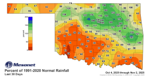
areas where soaking rainfall was received (graphic right)The week ahead
holds above normal temperature and dry conditions in place prompting
the expectation for gradually increasing wildfire occurrence although
initial attack efforts are expected to remain successful with limited large
fire potential (>300 acres) and very-low significant fire probabilities.
Today: Temperature will range from the 60°s in the Panhandle to around 80° in southwest Oklahoma under mostly-clear
skies. Relative humidity values will generally remain above 30% holding fine-dead fuel moisture at 6% or higher for most
of the state noting that southwest Oklahoma where warmer temperatures and relative humidity values +/-25% will offer
1Hr. fuel moisture at 5%. Windspeeds 4-12 mph will limit fire spread potential to <90 ft/min offering very good initial attack
opportunity. Timber fuels remain dominantly shaded and sheltered with average rates of spread15-25 ft/min.
Tuesday: Temperature remains above-normal with upper-70°s and low-80°s under mostly-clear skies. Afternoon relative
humidity values will tap 25% in southwest Oklahoma while most of the state holds higher than 30% limiting fine-dead fuel
moisture to 5-7% over most of the state. Afternoon observations nearer to 15% are expected in the western Panhandle
increasing receptiveness of fuels where dormancy is prevalent. Winds will be stronger as a southerly flow develops with
12-18 mph gusting to 30 mph will support more rapid fire spread potential. Range and grass-dominant areas will exhibit
head fire rates of spread 70-140 ft/min and flame lengths +/-10 ft. Initial attack, while challenging, is expected to remain
largely successful noting that a large fire occurring cannot be ruled out.
Near-Term Outlook: Warm/dry conditions hold in place for the remainder of the work week with Tuesday presenting the
highest fire danger of the week. Thursday is forecasted to be the warmest day of the week and breezy conditions in the
afternoon will again increase fire danger to some extent. There is some potential for a pattern shift late week/weekend
offering cooler temperatures although dry conditions are likely to persist.
County Burn Bans: Click HERE for current burn ban information.


