

Sun, 23 Oct 2022 12:05:17 CDT
A Red Flag Warning is in effect today from late morning through the early evening hours in the Panhandle and northwestern counties. Temperatures will again push above normal today across Oklahoma with strong winds over a very dry, receptive fuel bed. Fires that start today will again present potential for significant suppression difficulty and resistance to control especially in rangeland fuels where haying and grazing have been absent. High-Wind Warnings and Wind Advisories are also in effect today across most of Oklahoma with gusts this afternoon in the Panhandle counties potentially tapping 60 mph resulting in blowing dust and challenges to powerlines. Fire activity in the past two days has proven to be very challenging to suppress, with large fire occurrence in north-central Oklahoma. Increasing dewpoint temperatures will hold afternoon relative humidity values well above the critical threshold across the bulk of the state, however composite fuel dryness and the strength of the wind field translates to very active fire behavior on any wildfire that becomes established. Additionally, we will have significant fire potential across the Warned Area in the Panhandle and northwestern counties given the strength of fire weather over parched fuels, and enhanced likelihood in areas of north-central and northeastern Oklahoma given fuel dryness and the presence of large fires on the landscape from the previous two days. A cold front will push into the
Oklahoma Panhandle early Monday morning with the associated clockwise wind shift to the northwest challenging the east flank of any going fire. This front will migrate across the state on Monday with rain chances on the rise and very good opportunity for widespread, areal coverage.
Warned Area: Across the Panhandle and northwestern counties, marginal overnight moisture recovery and elevated overnight temperatures will warm into the 77°-86° range with relative humidity values 17-29%. Partly-cloudy conditions are anticipated coupled with blowing dust. Given sky cover, fine-dead fuel moisture values may not reach full potential, although if clearing occurs fine-dead fuel moisture will register 5% with some 4% observations possible. South-southwest winds sustained 22-35 mph with gusts above 40 mph (+/- 50-60 mph in the PH counties) will drive potential for extreme rates of fire spread on any fire that becomes established coupled with frequent torching in brush fuels and longer range spotting. In rangeland fuels where haying/grazing has been absent, head fire rates of spread of 188-283 ft/min (+/- 2.6 mph) with flame lengths 13-16 ft coupled with a deep flaming front should be expected. In areas where fuels and topography are aligned with wind direction, expected accelerated rates of spread eclipsing 300 ft/min (3.4 mph). The approaching cold front, and associated wind shift, may arrive as early as midnight in the
Panhandle counties progressing across the Warned area in the early morning hours. Any active fire will be influenced by this wind shift challenging suppression efforts on the eastern flank.
North-Central/Northeastern Oklahoma: Fire activity in recent days has proven to be very challenging with a couple of large, potentially significant fires. A surge of gulf moisture and potential for some cloud cover will serve to hold relative humidity values above critical threshold and subsequently result in elevated fine-dead, or carrier, fuel moisture values. Nonetheless, composite fuel moisture and the amount of recent fire activity in the area will support potential for large/significant fire occurrence across the area ahead of a cold front that does hold promise of beneficial moisture in tow. Temperature will warm into the mid-80°’s as clouds become scattered this afternoon. Relative humidity values will be much higher than in previous days with afternoon observations expected to be above 35% yielding fine-dead fuel moisture values at 7-8% across the area. Southerly winds this afternoon sustained 19-28 mph gusting around 35 mph will support rapid to extreme rates of fire spread as well as challenge containment efforts from previous days activities. Grass-dominated fuels will support head fire rates of spread 160-245 ft/min (+/- 2.4 mph) with flame lengths 16-21 ft. Mixed fuels, where brush/juniper is present, will exhibit problematic fire behavior including single/group tree torching and extended-range spotting. The approaching cold front will push rain chances into the area in the early morning hours after 1:00 AM coupled with winds shifting to the north. As the front approaches, firefighters should anticipate intensifying activity on the eastern flank and southern anchor point of any going/recent fire.
Along & South of I-40: Temperature will again be above normal in the mid- to upper-80°’s with sky cover persisting through much of the day. Relative humidity values will range from 32% in southwest Oklahoma to +40% elsewhere holding fine-dead fuel moisture values above critical thresholds at 7-8%. South winds will be stout sustained 15-25 mph with gusts topping 35 mph southwest and near 30 mph southeast. Grass-dominated fuels where grazing/haying has not occurred will support head fire rates of spread 115-176 ft/min (+/- 1.7 mph) with flame lengths 9-15 ft. Mixed fuels where brush/juniper are present will exhibit ROS 52-85 ft/min and FL 9-13 ft. with single/group tree torching. ROS in sheltered, timber-litter will be nearer to 20-35 ft/min with FL 4- 6 ft. Winds are expected to subside in the overnight hours as rain chances increase into the morning as a cold front approaches.
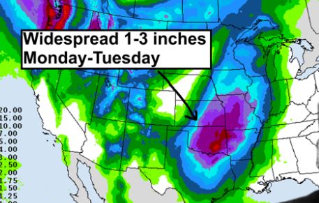
Near-Term: New fire starts today and challenges from recent wildfires are the focal point as a strong cold front approaches. With this cold front, there is a good chance for areal wetting rains Monday into Tuesday as is indicated in the Day 1-3 Quantitative Precipitation Forecast. Additionally, temperatures through the week ahead will be driven back into the ‘normal’ range. Another weather system late week hold some promise of another shot of moisture given current forecast. Fire danger is expected to diminish for a period, while the 8- 14 day outlook holds a return to above normal temperatures and dry conditions in western Oklahoma


