

According to the Oklahoma Mesonet, colder temperatures can be expected to come through this Friday and into the weekend; the panhandle may see single digits. The weather around Thanksgiving looks a bit unsettled, with some moisture possible, but not cold enough for snow or ice as of now.
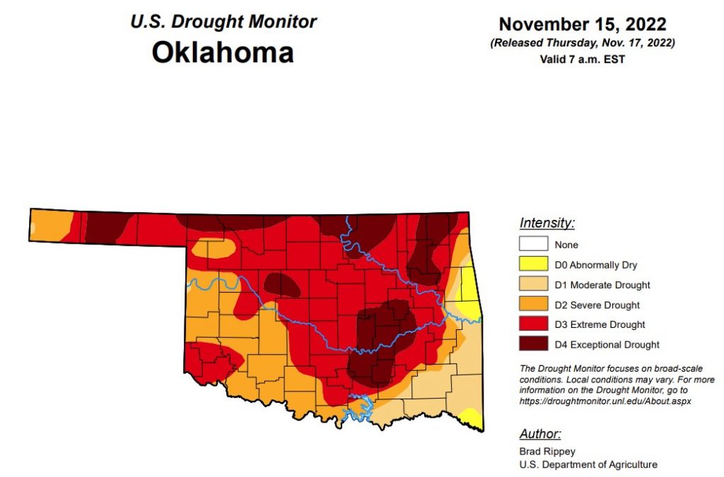
In Oklahoma, exceptional drought has improved from last week and is now at 19.67 percent (last week was at 22.38 percent).
Extreme drought or worse is down just slightly from last week’s 64.54 percent and is now at 64.07 percent.
Severe drought or worse is down from last week’s 88.7 percent and is now at 87.8 percent.
Moderate drought or worse is unchanged from last week at 97.7 percent, and abnormally dry or worse is also unchanged as it remains at 100 percent.
According to the 6–10-day precipitation map for Oklahoma, through November 26, all but the northern edge and southwest part of the state are predicted to receive near-normal amounts of precipitation. The far western edge of the panhandle is leaning below a 40 to 50 percent chance of rain, and the remaining part of the panhandle is learning below a 33 to 40 percent chance of rain.
To view the Oklahoma Drought Map, click here.
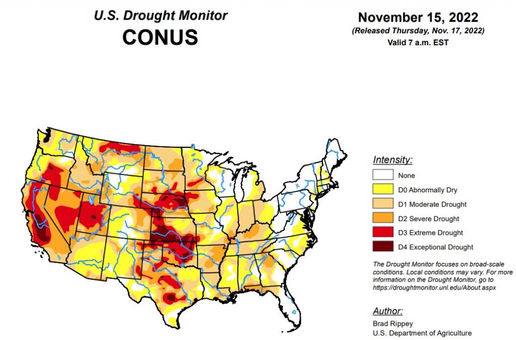
According to the latest U.S. drought monitor report, in some areas of the country, storminess chipped away and dryness and drought. Notably, on the 10th, Nicole became the first November hurricane to make landfall on the U.S. mainland since 1985, when Kate struck near Mexico Beach, Florida, on November 21. Nicole, a Category 1 hurricane with sustained winds near 75 mph, moved ashore just south of Vero Beach, Florida, around 3 am EST. Nicole’s remnants eventually affected the entire eastern U.S., providing varying degrees of relief from autumn dryness. Some of the heaviest rain, locally 4 inches or more, fell in the central and southern Appalachians and neighboring areas. The rain helped to boost streamflow in the upper reaches of the Ohio River basin, with runoff moving downstream as the drought-monitoring period ended. Farther west, a storm system produced heavy snow and local blizzard conditions in the north-central U.S., while parts of the West received drought-easing precipitation. However, many other areas of the country remained mostly dry. Frigid conditions developed in conjunction with the Western storminess and expanded eastward, while much of the lingering warmth in the South and East was swept away, shortly after Nicole’s departure.
To view the United States Drought Monitor Report, click here.
In the Southern Plains, late in the drought-monitoring period, precipitation developed across eastern sections of Oklahoma and Texas before spreading into the lower Mississippi Valley. Targeted reductions in drought coverage up to one category were made where the heaviest rain fell. However, much of the region received little or no precipitation. By November 13, the U.S. Department of Agriculture rated topsoil moisture at least one-half very short to short in Oklahoma (76%), Texas (71%), and Louisiana (58%). On the same date, the recently planted winter wheat crop continued to struggle in the driest areas, with 48% of the crop rated in very poor to poor condition in Texas, along with 42% in Oklahoma. In Arkansas, only 59% of the winter wheat had emerged by November 13, compared to the 5-year average of 66%. Rangeland and pastures continued to reflect the effects of drought, with 82% rated in very poor to poor condition in Oklahoma, along with 62% in Arkansas, and 57% in Texas.
In the High Plains, an early-season winter storm produced significant, wind-driven snow and freezing rain across parts of the Dakotas. Officially, 17.0 inches of snow—with a liquid equivalency of 1.23 inches—blanketed Bismarck, North Dakota, on November 10, accompanied by wind gusts as high as 37 mph. Elsewhere in North Dakota, wind gusts at the height of the storm reached or exceeded 40 mph in Garrison, Jamestown, and Minot. Bitterly cold weather trailed the storm. The northern Plains’ moisture, while highly beneficial for winter wheat, had a limited immediate effect on the drought situation, leading to only small improvements in the depiction. Farther south, drought continued to gradually worsen in other parts of the region. On November 13, the U.S. Department of Agriculture reported topsoil moisture rated very short to short ranging from 65% in North Dakota to 87% in South Dakota. On the same date, winter wheat across the region remained in dismal condition, with more than one-third of the crop rated very poor to poor in Colorado (45%), Kansas (40%), Nebraska (38%), and South Dakota (37%).
In the West, Over the past couple of weeks, beneficial precipitation has helped to establish high-elevation snowpack and has provided limited relief from long-term drought. The improved moisture has also benefited winter grains and cover crops. The latest round of significant rain and snow overspread much of the region early in the drought-monitoring period and lasted for several days. On November 7, the last full day of the previous period, Spokane, Washington, measured a daily-record snowfall of 3.8 inches. Also on the 7th, Elko, Nevada, set daily records for precipitation (0.76 inch) and snowfall (7.5 inches). Elko’s November 7-9 snowfall reached 13.1 inches. Similarly, Alta, UT, noted a 3-day (ending November 10) storm total of 27.7 inches. On November 8, daily-record amounts in southern California included 1.44 inches at Los Angeles International Airport and 1.13 inches in Burbank. Elsewhere in southern California, 48-hour totals on November 7-9 reached 6.84 inches on Palomar Mountain, 6.76 inches at Big Bear Lake, and 4.80 inches in Idyllwild. In Utah, 24-hour precipitation totals on November 8-9 topped an inch in Randolph (1.20 inches), Logan (1.09 inches), and Zion National Park (1.05 inches). Daily-record snowfall on the 9th totaled 3.1 inches in Pocatello, ID, and 3.0 inches in Kanab, UT. During the extended period of unsettled weather, Pocatello noted 8.8 inches of snow from November 7-10. Later, cold, dry weather replaced previously stormy conditions throughout the West. Sub-zero temperatures were common across the northern Rockies and northern Intermountain West, with Greybull, Wyoming, reporting five consecutive readings below 0°F from November 10-14, along with a daily-record low of -14°F on the 11th. In Glasgow, Montana, a daily-record low of -15°F on November 10 was preceded and accompanied by 11.5 inches of snow, starting on the 8th. Other sub-zero, daily-record lows in Montana included -15°F (on the 8th) in Great Falls and -17°F (on the 11th) in Miles City.
Looking ahead, Cold weather will continue to dominate much of the country through the weekend and into early next week. At the height of the cold wave, temperatures could fall to 20°F or below as far south as the Tennessee Valley, while freezes may reach nearly to the Gulf Coast in Louisiana, Mississippi, Alabama, and northern Florida. Meanwhile, continental U.S. storminess during the next 5 days will be minimal. However, snow squalls will continue for several days downwind of the Great Lakes. In addition, rain may develop in the western Gulf Coast region. Elsewhere, aside from snow showers in the Rockies and adjacent High Plains, dry weather will prevail during the next 5 days from the Pacific Coast eastward across the central and southern Plains, the middle and lower Mississippi Valley, and much of the Southeast.
The NWS 6- to 10-day outlook for November 22 – 26 calls for the likelihood of near- or above-normal temperatures nationwide, except for lingering cooler-than-normal conditions in the middle and northern Atlantic States and parts of the south-central U.S. Meanwhile, near- or below-normal precipitation from California to the Plains, Midwest, and mid-South should contrast with wetter-than-normal weather in the Northwest and large sections of the Gulf and Atlantic Coast States.
To view the 6-10 Day Precipitation Outlook Map, click here.
To view the 6-10 Day Temperature Outlook Map, click here.
To view the Monthly Drought Outlook Map, click here.


