

According to the Oklahoma Mesonet, the state sees a couple more chances of rainfall into the weekend and early next week.
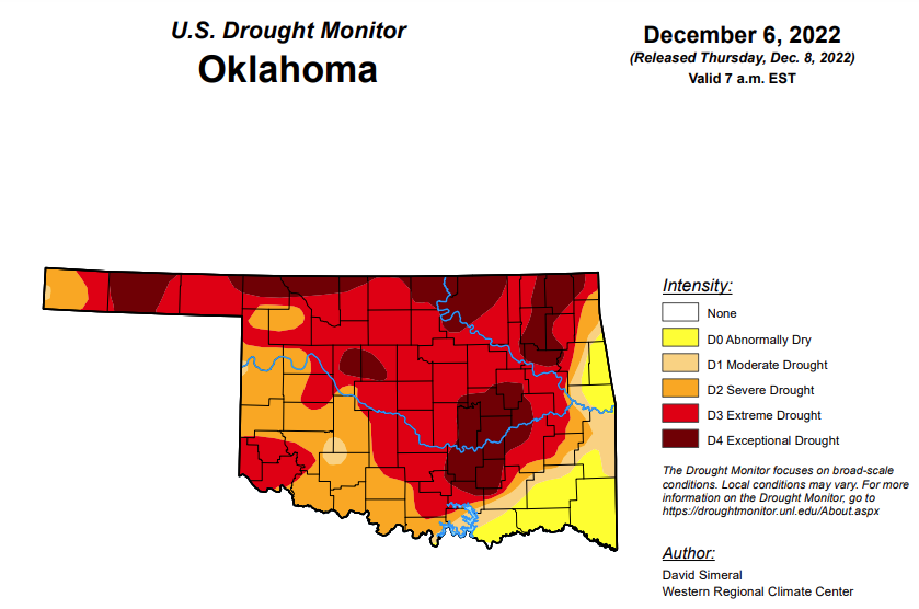
In Oklahoma, exceptional drought is up just slightly from last week’s 19.77 and is now at 19.88.
Extreme drought or worse is unchanged from last week at 64.01 percent.
Severe drought or worse is unchanged from last week at 85.98 percent.
Moderate drought or worse is unchanged from last week at 91.21 percent.
Abnormally dry or worse conditions are unchanged from last week at 99.97 percent.
According to the 6-10 day precipitation map for Oklahoma, through December 17, the majority of the state is leaning above a 33-40 percent chance of precipitation. The state’s southeast corner is leaning above a 40-50 percent chance of precipitation.
To view the Oklahoma Drought Map, click here.
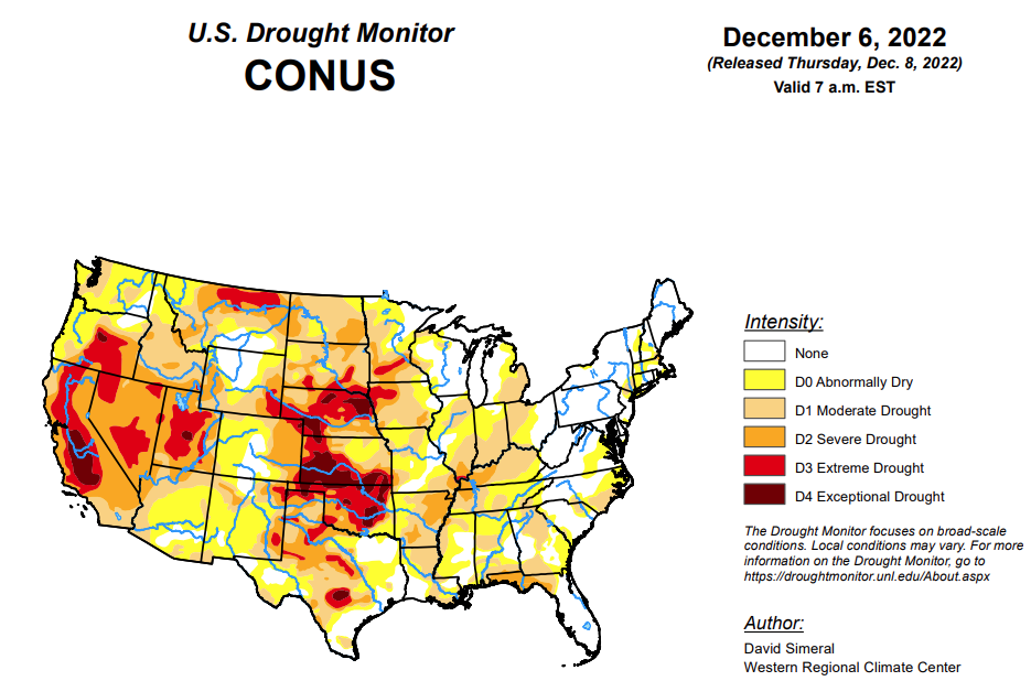
To view the United States Drought Monitor Report, click here.
According to the latest U.S. drought monitor report, this week saw an active storm pattern across much of the Western U.S. as well as another round of isolated heavy rainfall across portions of the South and Southeast. Out West, several rounds of Pacific moisture streamed into the region bringing heavy rains to the lower elevations of the Pacific Coast Ranges and snowfall to the higher elevations of the Sierra Nevada, Klamath Mountains, Cascades, northern Great Basin, and the central and northern Rockies. For the multi-day storm event, the heaviest snowfall accumulations were observed in the Sierra Nevada where up to four feet was observed including at the Central Sierra Snow Lab, which reported a 7-day snowfall total of 48.8 inches. Moreover, the storms boosted basin-wide snow water equivalent (SWE) to well above normal levels in the Sierra Nevada drainage basins and basins across the Intermountain West and Pacific Northwest, according to the National Resources Conservation Service (NRCS) SNOTEL network. Along the Central California coast in the Santa Lucia Range (south of Monterey), 7-day rainfall accumulations ranged from 4 to 11+ inches—helping to reduce longer-term precipitation deficits (past 24 months) that ranged from 8 to 20+ inches after this week’s storms. In the Desert Southwest, locally heavy rainfall was observed in southern Arizona and west-central New Mexico in association with sub-tropical moisture that moved into the region on Saturday with isolated areas receiving 2 to 3+ inches of rain. The rainfall improved soil moisture levels and helped to boost precipitation totals during the past 12-month period to normal to above-normal levels across much of the southern portion of Arizona. In the Northern Plains, light snowfall (2 to 6 inches) was observed in the Dakotas and eastern Montana in addition to the passage of an Arctic front early this week, which dropped temperatures into the single digits in North Dakota. In the Midwest, a wintery mix of rain, freezing rain, and snow impacted southern Wisconsin while light-to-moderate snowfall accumulations (2 to 6 inches) were observed in Minnesota and Upper Peninsula Michigan. In the Interior Deep South, locally heavy showers (2-to-4-inch accumulations) brought some relief to drought-affected areas of northern Alabama and Georgia as well as southeastern Tennessee, and southwestern North Carolina. In the Northeast, light-to-moderate snowfall accumulations (1 to 4 inches) were observed last week with the heaviest accumulations in Upstate New York. In Maine and New Hampshire, strong winds and shower activity (1 to 2 inches) impacted the region last week causing power outages in areas of Maine. In the South and Southeast, locally heavy rainfall was observed across a west-to-east band extending from northern Mississippi to northern Georgia. The storms helped to reduce short-term precipitation deficits (past 30-60 days) in some areas and boosted streamflows and soil moisture to above-normal levels.
In the Southern Plains, improvements to drought-related conditions were made on the map in areas of Arkansas, Mississippi, and Tennessee in response to rainfall over the past 30-day period. Elsewhere, some minor degradations occurred in South Texas and the Oklahoma Panhandle. Across the western portion of the region, generally dry conditions prevailed, while the eastern half saw rainfall accumulations ranging from 1 to 4+ inches with the highest totals logged in northeastern Mississippi and southern Tennessee. Average temperatures for the week were generally above normal (1 to 10 deg F) with the greatest anomalies observed in the Trans Pecos region of Texas and along the central Gulf Coast Region. In contrast, eastern Oklahoma, Arkansas, and Tennessee experienced average temperatures that were near to slightly below normal.
In the High Plains, improvements were made in northwestern Colorado and Wyoming. In Wyoming, recent storms delivered beneficial snowfall to the Teton and Wind River ranges leading to reduction in areas of Moderate Drought (D1). Moreover, the drainage basins in those ranges, the Snake Headwaters and Upper Green, were reporting SWE percentage of median levels of 129% and 114%, respectively. Additionally, areas of Moderate Drought (D1) were reduced in northwestern Colorado in response to improving conditions from recent storms and above-normal snowpack conditions including in the White-Yampa Basin (122% of median). In Kansas, continued dry conditions led to minor expansion of areas of Extreme Drought (D3) and Exceptional Drought (D4) in western Kansas. Looking at the past 9-month period in the western half of Kansas, precipitation deficits ranged from 3 to 12+ inches. For the week, average temperatures were mainly below normal, with the greatest departures (10 to 15 deg F below normal) observed in North Dakota and north-central Wyoming. In terms of precipitation, the region was generally dry, although some significant mountain snowfall was observed in western Wyoming and in the Rockies of Colorado, while lesser accumulations were reported in areas of the Dakotas.
In the West, back-to-back storm systems delivered significant rainfall accumulations to the lower elevations of California, Oregon, and Washington as well as heavy mountains snows to the Sierra Nevada, Klamath Mountains, and areas of the Cascades. Moreover, moderate-to-heavy snowfall accumulations were observed in the ranges of the northern Great Basin and the central and northern Rockies. The beneficial rains from the storms led to some minor improvements on the map along the Central Coast of California where rainfall totals exceeded 10 inches in isolated areas of the Santa Lucia Range. Elsewhere in California, no changes were made on the map this week. However, some targeted improvements are likely next week after a more thorough assessment of the impact of the storms in juxtaposition to the significant longer-term precipitation deficits across the state. Nonetheless, California’s snowpack is off to a positive start with the California Cooperative Snow Surveys reporting (12/6) statewide SWE at 171% of normal, with the Northern Sierra at 156%, Central Sierra 160%, and Southern Sierra 203% of normal. In the Southwest, some improvements were made on the map in drought-affected areas in southern Arizona in response to this week’s round of subtropical moisture that delivered locally heavy rains—improving soil moisture and streamflow conditions. In the Intermountain West, improvements were made on the map in areas of Extreme Drought (D3) in central and eastern Nevada as well as in Utah where conditions have improved during the past 6-month period across various indicators including soil moisture, streamflows, shallow groundwater, and precipitation. In southwest Montana, recent snowfall and overall improving conditions on various drought metrics led to removal of areas of Moderate Drought (D1) on the map. For the week, the northern half of the region experienced cooler-than-normal temperatures (2 to 20 deg F below normal) with the greatest departures observed along the northern border with Canada.
Looking ahead, the NWS WPC 7-Day Quantitative Precipitation Forecast (QPF) calls for moderate-to-heavy precipitation accumulations (including heavy snowfall accumulations) ranging from 2 to 4+ inches (liquid) across much of the Cascades of Oregon and Washington, Klamath Mountains, Coast Ranges of Northern California, and the Sierra Nevada Range-similar to last week’s QPF for the West Coast region. In the Intermountain West, 1-to-2-inch (liquid) accumulations are expected in the Rocky Mountains of Colorado, while lesser accumulations are expected in the Wasatch Range of Utah and the ranges of central and northern Idaho. Elsewhere in the conterminous U.S., another round of heavy precipitation accumulations is expected in Arkansas, southern Missouri, northern Mississippi, and eastern portions of Kentucky and Tennessee (3-to-5+-inches liquid). In areas of the Midwest and Northeast, accumulations are expected to be generally <1-inch. The CPC 6-10-day Outlooks call for a moderate-to-high probability of above-normal temperatures for the eastern half of the conterminous U.S. with near-normal temperatures across much of the Plains states, while the Western U.S. is forecasted to be below normal. In terms of precipitation, above-normal precipitation is expected across most of the conterminous U.S. except for western Texas and areas of New Mexico.
To view the 6-10 Day Precipitation Outlook Map, click here.
To view the 6-10 Day Temperature Outlook Map, click here.
To view the Monthly Drought Outlook Map, click here.


