

Statewide Discussion: Most of Oklahoma is currently 27-133 days separated from wetting precipitation with above normal temperatures firmly in place with dormant, available fuels dominating the landscape driving enhanced fire
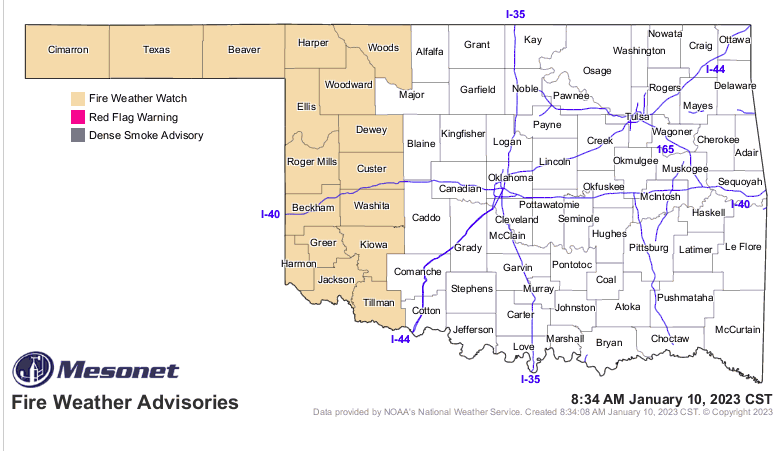
danger statewide. Fire weather inputs will remain below critical thresholds today while a Red Flag Warning is likely tomorrow across parts of far western Oklahoma, including the Panhandle counties. A Fire Weather Watch is in effect
for tomorrow (01/11/2023) across far western Oklahoma and the Oklahoma Panhandle in the pre-frontal fire environment where dry, dormant fuels will be very receptive and fire weather inputs will support potential for rapid rates of spread. Passage of the front is expected to be dry for most Oklahoma reserving rainfall chances for far eastern counties late Wednesday.
Western Oklahoma / Oklahoma Panhandle: Today, temperatures will be around 20 degrees above normal with afternoon
temperatures 68°-78° under mostly clear skies and relative humidity values 15-23% yielding fine-dead fuel moisture values at 4% across most of the area. Southwest to west winds sustained 10-20 mph with some higher gusts will support moderate to rapid rates of fire spread in rangeland fuels this afternoon. Head fire rates of spread of 154-200 ft/min with flame lengths 12 ft should be anticipated where grazing/haying has not occurred. Winds are expected to calm following sunset providing good opportunity to contain new fires.
Central/Eastern Oklahoma: The significant cold snap late in December thrust most cool-season species into dormancy
increasing dead fuel loading and overall fuel availability. The temperature this afternoon ranging from the mid-60°’s north to upper70°’s south-central coupled with relative humidity values 25% central to around 40% east will support fine-dead fuel moisture values 5-6% along I-35 and 7% further east. Southerly winds sustained 5-14 mph with some higher gusts will support moderate rates of fire spread in grass-dominated fuels 82-154 ft/min with head fire flame lengths 13 ft. Timber fuels will generally exhibit head fire ROS 15-25 ft/min with surface fire flame lengths 4-6 ft.
Near-Term: Fire danger will increase again on Wednesday as a cold front approaches. Ahead of the front, temperatures remain well-above normal with fine-dead fuel moisture values 4-5% and strong winds gusting near 40 mph in far western Oklahoma late in the afternoon. The temperature will drop with the frontal passage late Wednesday and relative humidity values increase overnight, although winds will likely remain elevated, especially west. Rainfall potential with this system is rather limited and reserved for eastern Oklahoma. Dry conditions prevail through the near-term forecast and elevated fire weather returns late-week as temperatures again rebound to above normal.


