

Not much change this week in the drought monitor report, and according to the Oklahoma Mesonet, warmer temperatures and below-normal precipitation can be expected through April. There is a chance for some snow in the Oklahoma panhandle this weekend, and northwest Oklahoma may see some precipitation (rain/snow mix) on Saturday.
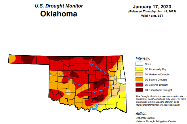
Exceptional drought is unchanged from last week’s 11.77 percent.
Extreme drought or worse has increased only slightly from last week, as it moved from 57.21 percent to 57.90 percent over the past week.
Severe drought or worse remains at 81.01 percent.
Moderately dry or worse also remains unchanged at 89.12 percent.
Abnormally dry or worse conditions see a slight change, with an increase from 97.46 percent to 97.96 percent.
To view the Oklahoma Drought Map, click here.
According to the 6–10-day precipitation outlook map, the majority of the state is leaning above a 33-40 percent chance of precipitation through January 28th. The far southeast corner of the state is leaning above a 40-50 percent chance of precipitation.

To view the United States Drought Monitor Report, click here.
According to the latest U.S. drought monitor report, an atmospheric river brought heavy rain and high-elevation snow across part of the West, leading to drought improvements in California, the Pacific Northwest, the northern Rockies and the Great Basin. A band of heavy rainfall, combined with severe weather, impacted the Southeast, leading to areas of drought improvement in Georgia. Meanwhile, persistent dryness led to the expansion of drought in the Carolinas. Drought in the High Plains remains largely unchanged; much of the excess moisture is tied up in snowpack and its effects on soil moisture and groundwater recharge remain to be seen. Drought expanded across parts of the South where short-term moisture deficits on top of longer-term drought continue to build.
In the Southern Plains, much of Oklahoma and Texas missed out on this week’s precipitation events, resulting in the expansion of drought. In Oklahoma, temperatures averaged 10 to 13 degrees above normal over the previous 2 weeks while precipitation has been less than 50% of normal over the past 4 months. Extreme (D3) drought expanded in response to well-below-normal (10th percentile or lower) measurements of streamflow, groundwater and soil moisture conditions. Texas also saw a swath of degradations from the north-central region to South Texas where short-term moisture deficits, on top of longer-term drought, have continued to build, and streamflow, soil moisture and groundwater levels range from below (10th to 24th percentile) to well below normal (10th percentile or lower). In the eastern part of the region, last week’s rainfall erased lingering areas of abnormal dryness.
In the High Plains, much of the High Plains remained in a holding pattern last week. Areas that received abundant snowfall over the Water Year are slow to make improvements due to the long-term nature of drought in the region. Until spring melt shows verified evidence of soil moisture and groundwater recharge, it will be difficult to tell how much effect snow has had on drought conditions. Severe (D2) drought improved in eastern North Dakota, which has received 16 to 20 inches of snow this season. No areas deteriorated significantly, except for areas of abnormal dryness (D0) in South Dakota and Colorado.
In the West, the long-term drought continues across California, the Great Basin and parts of the Pacific Northwest. However, a barrage of atmospheric river events – streams of moisture in the atmosphere that transport water vapor from the tropics – has reduced the drought intensity over the past few weeks. In California, 1-category improvements were made along the Northern Coast, around the Delta and along the South Coast region. While precipitation over much of the state was over 300% of normal over the previous 2 weeks (2 to 12.5 inches, depending on location), deficits have been years in the making. While this last round of rain has helped return smaller reservoirs to the historical averages, many of the larger reservoirs still remain below the historical average for this time of year. Historically, long-term drought is interrupted by a period of abnormally wet weather. However, it’s too early to tell if the wet weather is enough to end the drought. Many other parts of the West also saw improvements to drought and abnormally dry areas. In Oregon, 1-category improvements were made to extreme (D3) and severe (D2) drought in the southeast and near Klamath County based on above-average snow water equivalent and improvements to long-term indicators such as 6- to 24-month precipitation and shallow groundwater. In Idaho, severe (D2) and moderate (D1) drought improved where precipitation deficits over the past 12 months and streamflows show improvement. In Utah, areas of D3 and D2 improved based on precipitation in excess of 300% of normal (3 to 10 inches, depending on location) over the last 30 days and its resulting effect on streamflows, soil moisture, and groundwater. Heavy precipitation helped erase areas of abnormal dryness in parts of Washington, Oregon, western Wyoming, western Colorado, Arizona and New Mexico. The only places in the West seeing an expansion of drought were Oregon and Colorado. In Oregon, D1 was introduced in the south Willamette Valley and central Oregon Cascades and D1 and D2 expanded in the north-central part of the state. These expansions were in response to below-normal water-year-to date precipitation on top of longer-term deficits and groundwater impacts.
Looking ahead, The National Weather Service Weather Prediction Center forecast for the remainder of the week (valid January 18 – January 20) calls for a winter storm to bring freezing rain and snowfall to the High Plains and Upper Midwest. To the southeast, showers and thunderstorms are expected with localized areas of heavy rainfall. Chances will increase for a wintry mix of snow, sleet and freezing rain along the East Coast as the storm system moves into the northeast on Thursday. Much of the southern U.S. can expect unseasonably warm temperatures. Meanwhile, another storm system is expected to move southeastward through the Pacific Northwest into the Northern Rockies, the Great Basin, California and the Desert Southwest, bringing rain and snow at lower elevations and heavier mountain snow. Moving into next week (valid January 21 – January 25), the forecast calls for a storm system to track from the central Plains to the Northeast, bringing strong winds and wintry weather to the northern regions and rain to the south. At 8 – 14 days, the Climate Prediction Center Outlook (valid January 25 – January 31) calls for below-normal temperatures over most of the country except for the Northeast, Southeast and Alaska. The Northeast can expect near-normal temperatures, while the Southeast and Alaska have the greatest probability of warmer-than-normal temperatures. Most of the U.S. can expect near- to slightly above-normal precipitation. Only the Pacific Northwest and northern Minnesota have increased odds for below-normal precipitation.
To view the 6-10 Day Precipitation Outlook Map, click here.
To view the 6-10 Day Temperature Outlook Map, click here.
To view the Monthly Drought Outlook Map, click here.


