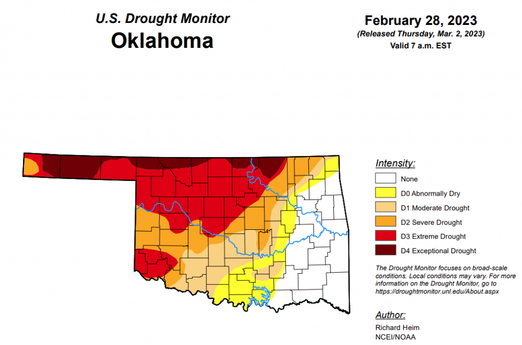
To view the Oklahoma Drought Map, click here.
Exceptional drought is unchanged this week at 8.86 percent.
Extreme drought or worse is also unchanged from last week at 36.64 percent.
Severe drought or worse has improved slightly from last week’s percentage of 56.47 percent to this week’s 53.52 percent.
Moderate drought or worse has improved since last week and is now at 66.88 percent, down from last week’s 74.65 percent.
Abnormally dry or worse conditions are now at 77.15 percent, down from last week’s 80.78 percent.
According to the 6-to-10-day precipitation outlook map, the majority of the state, aside from the panhandle, is leaning above a 40 to 50 percent chance of precipitation through March 11. The panhandle is sitting above a 50 to 60 percent chance of precipitation through March 11.

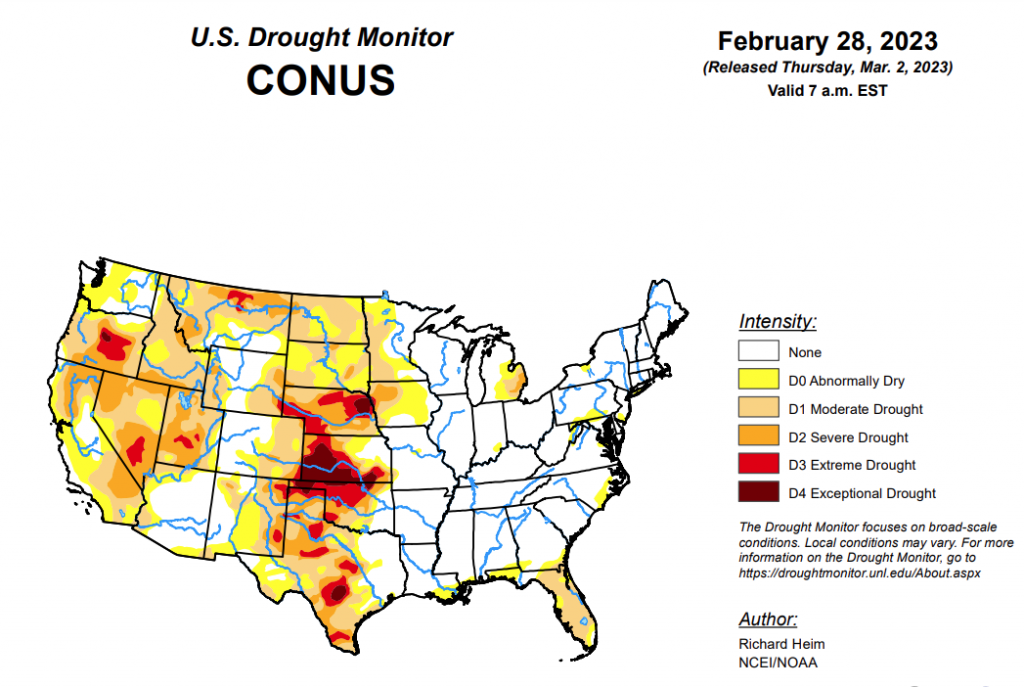
To view the United States Drought Monitor Report, click here.
According to the latest U.S. Drought Monitor Report, a series of Pacific low pressure and frontal systems moved across the western contiguous U.S. (CONUS) during this U.S. Drought Monitor (USDM) week (February 22-28). The weather systems dropped copious amounts of rain and snow across the West, especially over the Sierra and coastal ranges and Rocky Mountains. The weather systems re-intensified as they crossed the Plains and into the Midwest, tapping Gulf of Mexico moisture to spread several inches of rain over northeast Texas to the Appalachians and Ohio Valley, with several inches of snow falling in the below-freezing air across the northern tier states from the Dakotas to New England. A high-pressure ridge over the Gulf of Mexico generated a southerly flow that spread warmer-than-normal air from the Gulf Coast to southern Great Lakes. It also pushed the low-pressure systems along a storm track that went northeastward from the southern and central Plains to the Great Lakes. Temperatures averaged cooler than normal across the snowy northern states, across the central to northern Plains, and over the West. Little to no precipitation fell across the Gulf Coast, western portions of the southern and central Plains, and over the northern Plains near the Canadian border. It was also drier than normal over parts of the Pacific Northwest, northern New England, and the Mid-Atlantic states. Wetter-than-normal conditions were widespread across the rest of the West, parts of the northern and central Plains and Northeast, and much of the Midwest. Drought or abnormal dryness expanded where it continued dry in parts of Texas, Florida, and other Gulf Coast states. Drought or abnormal dryness contracted or reduced in intensity where it was wet across much of California and other parts of the West and Plains, as well as part of the Great Lakes region.
In the Southern Plains, two inches or more of precipitation fell in strips across Arkansas and eastern Oklahoma, with half an inch or more stretching from northeast Texas to Tennessee. But little to no precipitation fell across western and southern areas of the region. Abnormal dryness and moderate to extreme drought were trimmed in parts of eastern Oklahoma and north-central Texas, but abnormal dryness expanded along the Gulf Coast in Louisiana and Mississippi. Abnormal dryness and moderate to extreme drought expanded in parts of the southern half of Texas as streamflow, soil moisture, and groundwater continued at very low levels. High winds, low humidity, and hot temperatures continued to dry out the soils. Two years of drought in the southern Plains were capped this week by raging dust storms. The continued dry weather, and now 100+ mph winds with low humidity, have desiccated crops, with the media reporting that the dryland wheat crop in parts of Texas, Oklahoma, and Kansas could see abandonment rates up to 80%.
In the High Plains, the region experienced a patchwork pattern of precipitation this week. The Rocky Mountain areas of Wyoming and Colorado, as well as the eastern half of Kansas, received half an inch to locally 2 inches or more of precipitation, and half an inch fell across South Dakota and northern and eastern parts of Nebraska. But North Dakota, eastern Colorado, and adjacent parts of Kansas and Nebraska were drier, receiving less than half an inch. This winter has been particularly wet for central to northern portions of the High Plains region, while Kansas and parts of southeast Colorado have missed out on the above-normal winter precipitation. The heat and dryness of last summer and fall dried out soils, and as winter set in the soils froze in the northern states, locking the dryness into place. The precipitation this week and earlier weeks resulted in contraction of moderate to severe drought in the Dakotas to Nebraska, and exceptional drought in Nebraska, but abnormal dryness was kept to reflect the leftover dry state of the frozen soils. Abnormal dryness contracted in parts of Colorado and Wyoming, and abnormal dryness and moderate to exceptional drought contracted in eastern Kansas.
In the West, much of the western CONUS has suffered from episodes of drought since 1999. The most recent drought episode has lasted up to 3 years. The lack of precipitation was accompanied by excessive heat, which increased evapotranspiration and further dried soils. The prolonged drought lowered groundwater and reservoir levels. The Pacific weather systems of this week and last week added to copious precipitation that has been received from atmospheric rivers since December 2022, especially over California and states to the east. The coastal mountain ranges, Sierra Nevada, and central to southern Rockies received 2 inches or more of precipitation this week, with totals exceeding 5 inches in parts of California. The heavy rains this week resulted in widespread flash flooding in parts of California. Some interior parts of the West had half an inch or more of precipitation, but favored rainshadow areas received less than a fourth of an inch. According to SNOTEL observations, 4 feet or more of new snow fell across the Sierra Nevada range this week. The SNOTEL station at Css Lab reported 78 inches of new snow, bringing the total snow depth to 178 inches as of February 28. Mt. Rose Ski Area reported 178 inches of snow on the ground, Ebbetts Pass reported 176 inches, and Echo Peak had 172 inches. The Hanford, California, area received 9.59 inches of precipitation during December 1, 2022-February 26, 2023. This is the third highest amount for the December 1-February 26 period in the 1900-2023 history for the Hanford area. The rain has improved California soil moisture and streamflow levels, while the snow has increased mountain snowpack to much above-normal levels. Most California reservoirs have refilled with water levels near or above average, but groundwater levels remain low and may take months to recover. Abnormal dryness and moderate to severe drought were contracted across much of California to reflect the above-normal precipitation of recent months, above-normal snowpack, and improved reservoir levels. According to USDM statistics, central California’s Sierra Nevada mountains and foothills are now free of drought and abnormal dryness for the first time since January 2020. Abnormal dryness and moderate to extreme drought were trimmed in Montana, abnormal dryness and moderate to severe drought contracted in New Mexico, and abnormal dryness and moderate drought were pulled back in Arizona. Soil moisture and mountain snowpack have improved in Utah, but groundwater and many reservoirs continue at very low levels. Abnormal dryness and moderate to severe drought were trimmed in Utah in areas where reservoir levels have improved sufficiently. The precipitation in the Pacific Northwest, especially Oregon, was not sufficient to warrant improvement in the drought depiction. In Oregon, reservoirs remain depleted at record to near-record low levels. The southwest Oregon reservoirs have improved only a couple percent over the last two weeks: Emigrant reservoir’s level rose from 21% full on February 16 to only 22% full by February 27; Hyatt increased from 14% to only 15%; Howard Prairie from 17% to 18%; and Agate from 35% to 37%.
Looking Ahead, as this USDM week ended, one weather system was moving across the Northeast and another was slamming into the West. More Pacific weather systems will follow during March 2-7, bringing half an inch or more of precipitation to the West Coast and higher elevations of the West, parts of the Great Plains, and much of the CONUS to the east of the Plains. Another 4 inches or more of precipitation can be expected for the Sierra Nevada and coastal ranges, and from northeastern Texas and eastern Oklahoma to the Ohio Valley and southern Appalachians. An inch or more of precipitation should be widespread from eastern Kansas to the southern Great Lakes, and from the eastern Great Lakes to the Northeast and Mid-Atlantic states. Western and some central parts of the Great Plains, especially Nebraska, western Texas, and southeast New Mexico, as well as southern California to the Great Basin, are forecast to receive less than half an inch of precipitation. Temperatures are predicted to be warmer than normal in the south and southeast to cooler than normal in the West. A cooler- and wetter-than-normal pattern is likely for March 8-15 across the CONUS. The Gulf of Mexico coast and much of Alaska likely begin this period warmer than normal, but odds favor cooler-than-normal temperatures as the period progresses. At the beginning of this period, below-normal precipitation is favored in the Northeast and Great Lakes, but below-normal precipitation is expected to dominate the southern half of Alaska through the period.
To view the 6-10 Day Precipitation Outlook Map, click here.
To view the 6-10 Day Temperature Outlook Map, click here.
To view the Monthly Drought Outlook Map, click here.


