

Statewide Discussion: Temperature will again push to well-above normal Sunday afternoon accompanied by a dryline expanding into the Panhandle, northwestern and far western counties. Above-normal temperatures, low relative humidity and gusty winds will bring critical to near-critical fire weather into the area. While winds will be gusty across most of Oklahoma on Sunday, the critical fire weather combination will hold along and west of a line from Woods County to Beckham County. Warm and dry conditions continue into Monday although wind speeds will be tamer with as a cold front begins to sink into the area.
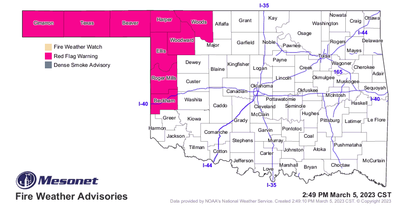
Today: A Red Flag Warning is in effect from 1:00 PM through 8:00 PM in the Panhandle and from Noon through 6:00 PM in the northwestern and far-western counties. A dryline will push into the Warned Area as temperatures warm to +15°
above normal, and relative humidity values drop into the 6-18% range with strong, gusty southwest winds. The rest of Oklahoma will experience elevated fire weather, although relative humidity values holding above 20% will hold fine-dead fuel moisture just above critical threshold. Nonetheless, stout south-southwest winds will present potential for moderate to rapid rates of fire spread in grass-dominated fuels. Winds will gradually taper off overnight. Initial attack activity is expected to increase and some large fire occurrence is anticipated. Significant fire occurrence remains very limited.
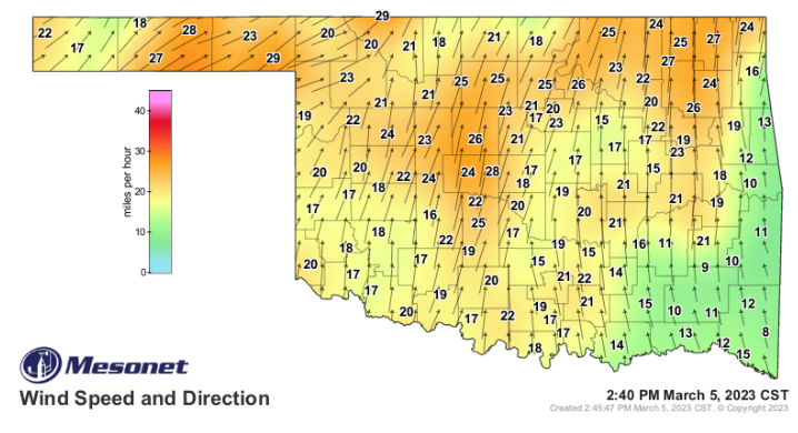
• Warned Area: As the dryline pushes in temperature 75°-80° and relative humidity values 6-18% under partly cloudy skies will yield very receptive fine fuels at 3% with some 2% observations likely in the western half of the Oklahoma Panhandle. Southwest winds will increase through the morning with afternoon winds sustained 19-26 mph and some gusts nearing 40 mph. Average rangeland fuels within the Warned Area will exhibit head fire rates of spread at 150-235 ft/min (2.2 mph) during peak burning conditions with flame lengths 8-15 ft. Those areas where heavier fuel loading remains, ROS 245- 305 ft/min (+/-3.1 mph) with FL 14-17 ft. Relative humidity will be slow to recover, and winds remain sustained above 15 mph well into the evening supporting an extended burning period.
• Along & West of I-44: East of the dryline, relative humidity values will not be quite as low registering 24-35% although
temperature will be above normal in the upper-70°’s to 80° along the Red River yielding fine-dead fuel moisture values in
the 5-6% range. With southerly winds sustained 17-23 gusting near 30 mph, rangeland fuels will exhibit head fire rates of
spread 120-168 ft/min (+/-1.6 mph) and flame length 8-13 ft during peak burning conditions. Areas where grazing has not
occurred could see ROS around 200 ft/min (2.3 mph) with FL 12-15 ft. Relative humidity values rebound above 45% by
2200 hrs. offering respectable opportunity for successful initial attack although large fire occurrence (>300 acres) is
possible.
• East of I-44: Wind speeds remain elevated in the counties along I-44 tapering off in intensity further south and east. Recent rainfall has prompted notable cool-season green up with the most notable effects in ag fields, grazed pastures and along roadways offering numerous barriers to fire spread. Temperature in the mid- to upper-70°’s and relative humidity values 28-37% will hold fine-dead fuel moisture in the 6-7% range. Head fire rates of spread 110-160 ft/min with flame lengths 7-12 ft are likely in un-grazed grasses with some single and group tree torching in open brush. Timber-litter fuels will present muted spread potential 18-30 ft/min. Relative humidity values will improve after sunset while winds taper off in the overnight hours offering good opportunity for successful initial attack efforts.
Monday: Warm and dry conditions continue, although winds will be calmer as a cold front filter into Oklahoma. Well above normal temperatures continue in the state’s southern half while northwestern counties will top out near normal as the cold front sinks south. Relative humidity values will register below 30% west of I-44, presenting receptive fuels, although diminished wind speeds hold spread potential in the moderate range, generally less than 100 ft/min.
Near-Term: Rain chances appear on Tuesday in northeastern Oklahoma, with better
opportunities further west Tuesday evening and Wednesday. Unfortunately, the super parched Panhandle and far northwestern counties do not have the best opportunity for a wetting event based on current forecast data. Nonetheless, a cooler/wetter pattern appears to be on tap by mid-week.
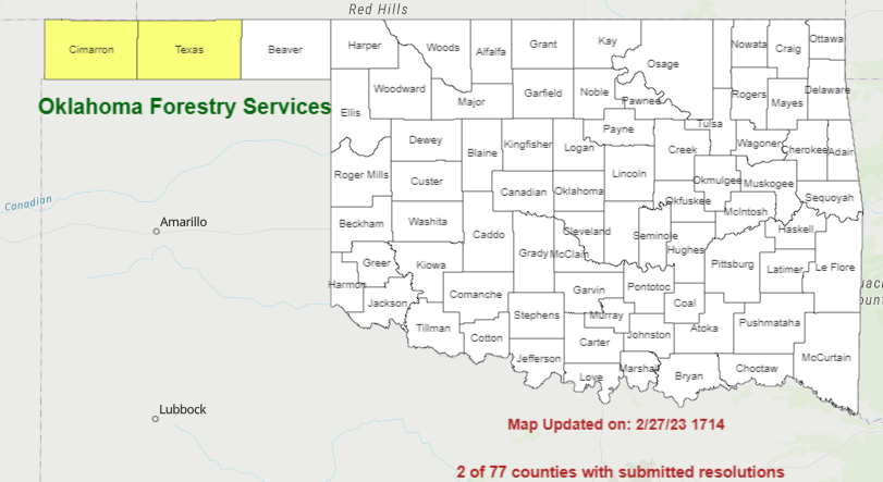
Burn Bans: Refer to: https://ag.ok.gov/divisions/forestry-services/ for the most current burn ban information and links to a specific burn banproclamations


