

To view the Oklahoma Drought Map, click here.
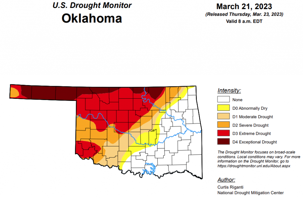
After four weeks of no changes in the exceptional drought category, this week, exceptional drought has increased from 8.86 percent to 11.21 percent in Oklahoma.
Extreme drought or worse is still at 36.64 percent- the same as weeks before.
Severe drought or worse is virtually unchanged, moving from last week’s 50.58 percent to this week’s 50.12 percent.
Moderate drought or worse is unchanged from last week at 59.07 percent.
Abnormally dry or worse conditions are also the same as last week at 65.61 percent.
According to the 6-10 day precipitation outlook map, the northwest corner and the panhandle regions of Oklahoma stand at a near normal chance of precipitation through April 1. The southwest corner, up through central Oklahoma and the northeast corner of the state are learning above a 33 to 40 percent chance of precipitation. As for the southeast corner, that part of the state is learning above a 40 to 50 percent chance of precipitation through April 1.
To view the United States Drought Monitor Report, click here.
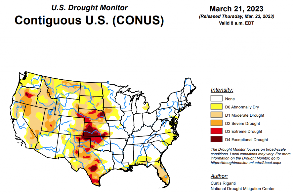
According to the latest U.S. drought monitor report, his week, heavy precipitation fell in parts of the West, especially in California, while drier weather generally occurred in the Great Plains east of the Rocky Mountains. Heavier precipitation also fell along parts of the Rio Grande in Texas, leading to some improvements of drought conditions there. Widespread precipitation amounts at or above a half inch fell in east Texas eastward into the Southeast, and from near Interstate 44 in Oklahoma eastward into Arkansas and southern Missouri. New York and southern New England also saw near a half inch of precipitation this week, with localized higher amounts. Dry weather continued in parts of the Florida Peninsula, where severe drought coverage increased in several areas. In response to rainfall in central Puerto Rico but continued dry conditions in the northwest, abnormal dryness coverage shifted a bit there. Recent dry weeks in Hawaii led to decreased streamflows and the introduction of abnormal dryness on all islands except Kauai and Niihau. For more detailed information for each region, please refer to the paragraphs below.
In the Southern Plains, widespread precipitation amounts of at least a half inch fell across the eastern two-thirds of the region, with localized spots in far east Texas, Louisiana, southwest Mississippi and central Arkansas reaching 2 inches. Oklahoma northwest of Interstate 44 and much of central and west Texas had mostly dry weather this week. Exceptions to this occurred in many areas along the Rio Grande from the Big Bend east in southern Texas, which received localized heavier precipitation amounts from 0.5 to 2 inches. Temperatures across the South region this week were generally 5 to 15 degrees cooler than normal. Continued dry conditions in the Oklahoma and Texas panhandles led to expansions of severe and exceptional drought where soil moisture and groundwater levels continued to drop. In the northern Texas Panhandle, the winter wheat crop is in danger of total failure, which is indicative of the soil moisture and precipitation deficit problems in the area. In areas that mostly missed out on heavier rains in central Texas, streamflow continued to drop amid growing precipitation deficits, leading to expansion of drought and abnormal dryness in some locations. Farther south, in the Big Bend region and in south-central Texas, localized improvements were made due to benefits from recent heavier rainfall. Ongoing short- and long-term drought and abnormal dryness remained unchanged in southern Louisiana and Mississippi, and the rest of the region remained free of drought or abnormal dryness.
In the High Plains, temperatures in the High Plains region were mostly below normal for the week. The most significant departures occurred in the Dakotas, where temperatures mainly ranged from 15 to 25 degrees colder than normal outside of southwest South Dakota. Precipitation fell in some of the high elevation areas of Colorado and Wyoming this week; otherwise, the weather was mostly dry in the High Plains region. Moderate and severe drought expanded slightly in southeast Kansas; please see the Midwest paragraph for more details on this. Due to recent snowfall and lessening precipitation deficits, portions of northwest North Dakota saw reductions in moderate and severe long-term drought coverage. Otherwise, ongoing long-term drought was unchanged east of the Rocky Mountains. In north-central South Dakota, stock pond levels and river levels remained low, despite some recent snowmelt, indicative of long-term dryness there. Parts of the Sangre de Cristo Mountains and far eastern San Luis Valley saw some improvements due to increased snowpack. Increased recent precipitation in southwest Wyoming allowed for the removal of severe drought.
In the West, most of the West saw temperatures near or below normal for the week, with a few areas of temperatures between 10 and 15 degrees below normal occurring in the Intermountain West, especially in Utah, Idaho, Nevada and Oregon. Widespread precipitation in the form of rain and snow, with localized very heavy amounts, occurred in parts of the region, especially in the San Bernardino and Sierra Nevada Mountains in California. A few spots in the northern Sierra Nevada saw improvements where snowpack increased further. Lush vegetation was reported in San Bernardino County, California, indicative of the very wet recent weather. The effects of recent wet weather will continue to be analyzed in the coming weeks over this area, and slight improvements to lingering abnormal dryness were made in southwest California this week. Large areas of severe and extreme drought in northern Nevada, northern Utah, Oregon, southern Idaho and northern Montana saw improvements due to recent precipitation and lessening precipitation deficits. Due to increased soil moisture and lessened precipitation deficits, improvements to ongoing long-term drought and abnormal dryness were also made in southeast Arizona and southwest New Mexico, and in portions of south-central and northwest New Mexico.
Looking ahead, through the afternoon of Monday, March 27, the National Weather Service Weather Prediction Center is forecasting mainly dry weather in the northern Great Plains, Minnesota and northwest Wisconsin. Mostly dry weather is also forecast in most of the Florida Peninsula, where short-term moderate and severe drought has intensified recently. Aside from some of the higher elevation areas, mostly drier weather is forecast in southern Nevada, southeast California, Utah and New Mexico. Heavier precipitation amounts are forecast for parts of western Oregon and Washington and far northwest California. Heavy rainfall, locally up to or exceeding 3 inches, is forecast along and south of the Interstates 44 and 70 corridors from far northeast Oklahoma into Ohio. Widespread rain amounts of at least 1.5 inches are likely in the northern halves of Georgia, Alabama and Mississippi, and in the southwest half of Tennessee. Widespread precipitation amounts of 0.5-0.75 inches are likely in much of the Northeast, with localized higher amounts.
To view the 6-10 Day Precipitation Outlook Map, click here.
To view the 6-10 Day Temperature Outlook Map, click here.
To view the Monthly Drought Outlook Map, click here.


