

To view the Oklahoma Drought Map, click here.
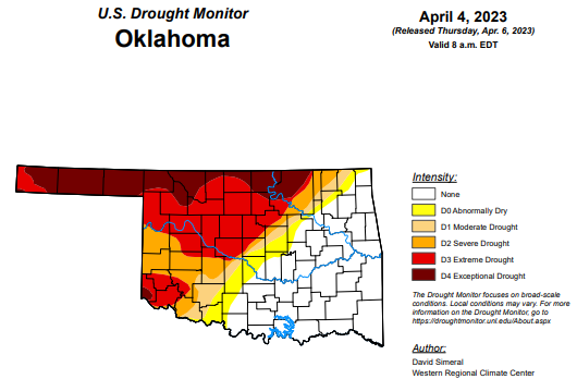
According to the latest Oklahoma Drought Monitor Report, exceptional drought increased from last week’s 12.83 percent to this week’s 15.27 percent.
Extreme drought or worse is virtually the same, moving from last week’s 37.30 percent to 37.99 percent.
Severe drought or worse is unchanged from last week, remaining at 48.59 percent.
Moderate drought or worse has moved from last week’s 53.68 percent to 53.65 percent.
Abnormally dry or worse conditions are virtually the same, moving from last week’s 60.31 percent to this week’s 60.30 percent.
According to the 6–10-day Precipitation Outlook map, the majority of Oklahoma is leaning above a 40 to 50 percent chance of precipitation through April 15th. The western half of the panhandle, along with eastern Oklahoma, is leaning above a 33 to 40 percent chance of precipitation. Further east, the chances of precipitation are near normal.
To view the United States Drought Monitor Report, click here.
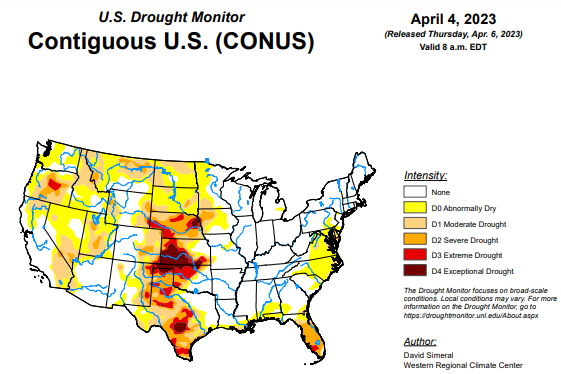
According to this week’s U.S. drought monitor, this week saw continued widespread improvements on the map across areas of the western U.S. including in California, Nevada, Oregon, Idaho, and Utah. Overall, the areal extent of drought in the West dipped to 31% this week as compared to 73% at the beginning of the Water Year in early October. This week’s improvements reflected the impact of the recent storm events which continued to boost mountain snowpack levels to record, or near-record levels as observed at numerous Natural Resources Conservation Service (NRCS) SNOTEL monitoring stations across the Sierra Nevada, southern Cascades, eastern Great Basin, Wasatch, Uintas, and the southern and central Rockies. In California, the statewide snowpack was 243% of normal (April 5), with the Northern Sierra at 198%, Central Sierra at 242%, and Southern Sierra at 302%. Elsewhere in the region, the state of Utah is observing historic snowpack levels with the statewide snow water equivalent (SWE) at its highest level on record (April 5) at 211% of median, according to NRCS SNOTEL. In other regions, areas of the South (Texas) and the Southern Plains (Kansas, Oklahoma) saw further degradations on the map in response to a combination of short and long-term dry conditions, very low streamflow and reservoir levels, and reported impacts in the agricultural sector. In the High Plains, blizzard-like conditions and moderate to heavy snowfall accumulations were observed in the Dakotas during the past week as well as in areas of the Upper Midwest including northwestern Minnesota. In the Southeast, dry conditions and reports of deteriorating pasture conditions led to the expansion of severe drought areas in central Florida. Likewise, short-term precipitation deficits and increasing fire danger in areas of the Coastal Plain of North Carolina led to the expansion of areas of drought.
In the Southern Plains, in the South, a major outbreak of severe weather impacted portions of the region, including in the Mississippi and Tennessee valleys where numerous tornadoes touched down. The severe weather outbreak included strong thunderstorms with excessive rainfall, large hail, damaging winds, and violent tornadoes which impacted areas of Arkansas and Tennessee, leading to loss of lives and the destruction of homes and businesses. On the map, areas of drought intensified and expanded across areas of Texas and Oklahoma where precipitation deficits during the past 12-month period ranged from 8 to 20 inches in the most severely affected areas. According to the USDA (April 2), the percentage of topsoil moisture in Texas and Oklahoma that was rated short to very short was 72% and 63%, respectively. Moreover, numerous reservoirs in the western half of Texas were below normal levels, including the San Antonio River Basin reservoirs which are currently 5.3% full, according to Water Data for Texas. In terms of streamflow levels, areas of Oklahoma (northern and western) and Texas (Hill Country and South Texas Plains regions) observed 7-day streamflows in the <10th percentile range, according to the U.S. Geological Survey. For the week, average temperatures were above normal (1 to 8 deg. F) across the region with the greatest departures observed along the Gulf Coast and South Texas Plains.
In the High Plains, on this week’s map, changes were made including a slight expansion of an area of Exceptional Drought (D4) in central Kansas as well as one-category improvements in areas of Moderate Drought (D1) and Severe Drought (D2) in South Dakota in response to improving soil moisture conditions, snow cover, and above-normal precipitation during the past 30-90-day period in some areas. Currently, 50% of Kansas is depicted in the D3-D4 drought categories with 12-month precipitation deficits ranging from 4 to 16 inches. According to the latest USDA Kansas Crop Progress and Condition report (April 3), winter wheat conditions were rated 31% very poor, 26% poor, 27% fair, 14% good, and 2% excellent. In terms of topsoil moisture conditions (April 2, USDA), the percentage of topsoil moisture rated short to very short was 73% in Kansas and 56% in Nebraska. In the Northern Plains, blizzard-like conditions were observed during the past week bringing heavy snowfall to eastern Wyoming, northwestern Nebraska, and the Dakotas. According to NOAA NOHRSC, 72-hour snowfall accumulations as of April 5 ranged from 6 to 24 inches. For the week, average temperatures were well below normal with departures ranging from 5 to 25 deg. F below normal with the largest departures observed in North Dakota.
In the West, out West, widespread improvements were made on the map including areas of California, Nevada, Oregon, Idaho, Utah, Montana, Wyoming, and New Mexico in response to excellent snowpack conditions across many of the drainage basins in the region. In California, the statewide snowpack (April 5) was 243% of normal, with the Northern Sierra at 198%, Central Sierra at 242%, and Southern Sierra at 302%. The California Department of Water Resources reported that the 2022-23 season will go down as one of the largest snowpacks on record in California. In Nevada and Utah, current SWE percentages of median for select basins are as follows: Central Lahontan 273%, Central Nevada Desert Basins 267%, Great Salt Lake 224%, Lower Green 202%, Upper Colorado-Dolores 207%, and Upper Colorado-Dirty Devil 219%, according to the NRCS SNOTEL network. In Arizona and New Mexico, snowpack levels are above normal, especially in the ranges of northern and central Arizona. In Arizona, the total reservoir system (Salt and Verde River system) is currently 100% full as compared to 72% full at the same time last year, according to the Salt River Project. For the Colorado River system, the U.S. Bureau of Reclamation is reporting (April 4) Lake Mead at 28% full and Lake Powell at 23% full.
To view the 6-10 Day Precipitation Outlook Map, click here.
To view the 6-10 Day Temperature Outlook Map, click here.
To view the Monthly Drought Outlook Map, click here.


