Despite more than 1 million moose (Alces alces) living in North America, with approximately 3,000–4,000 located in New Hampshire, the usually shy animal is notoriously difficult to spot. However, the region’s largest land mammal plays an important cultural and ecological role in the area, influencing tourism and impacting forest and wildlife composition where it feeds but also being vectors of parasites and diseases and involved in approximately 500 vehicle collisions per year in New England. As such, accurately tracking and estimating moose populations is key to conserving and managing the species, and new research led by New Hampshire Agricultural Experiment Station scientist Remington Moll assessed how emerging technologies may help improve population calculations of this animal introvert.
Moll, an assistant professor of natural resources and the environment at the UNH College of Life Sciences and Agriculture, and members of his Wildlife Modeling and Management Lab assessed 89 moose population studies and the methods used by each to determine which approach most accurately estimated population and density. They published their findings in Alces journal. Traditionally, moose population density has been measured with winter aerial surveying using helicopters. However, alternative approaches, such as surveys of hunters’ harvests, unpiloted aerial systems (drones) and camera trapping, are being used more frequently.
The research found that aerial surveying was used in more than half of the assessed studies, as was “sightability”—surveying in which moose were actually seen and identified. Assessments that did not account for “sightability” likely underestimated moose population density, often due to the wide range that moose often inhabit—upwards of 40 square miles in the summer and less than 15 miles in the winter—that makes estimating species density challenging, Moll explained.
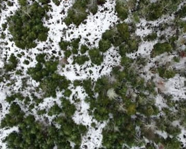
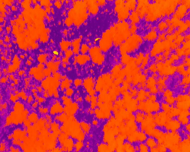
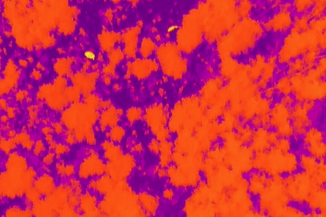
Images taken by drone (approx. 250 feet in height) showing the study area in northern New Hampshire. Left/top: Aerial image of study site. Right/bottom: Same study site using thermal imagery. With the thermal view, the cow (female moose) and her calf are clearly visible in bright yellow.
Photo credit: Franklin Sullivan
“Accounting for sightability involves formally adjusting estimates to count moose that were present but not detected,” described Moll. “Although some studies make this adjustment, almost half did not, which suggests that many estimates might be undercounts.”
“We also found that moose, in general, are a low-density species, with some of the highest population densities in the world located in Maine,” he added.
The team included scientists from the New Hampshire Fish and Game Department and the Maine Department of Inland Fisheries and Wildlife. Moll and his coauthors reported that emerging technologies, such as camera trapping, drone surveying and integrated population models—the latter of which provide population estimates based on combining multiple datasets—could complement aerial surveying to provide more accurate density estimates.
Moose Surveying Methods & Definitions:
Aerial Surveying: Method of surveying using visual and infrared imaging and video device(s)–i.e., cameras–attached to a piloted aircraft or unpiloted aerial system (UAS), also known as a drone.
Camera Trap: A camera connected to a sensor that, when activated by motion, heat or other means, will take photo and/or video. Infrared camera traps were introduced in the 1990s. One of the largest collective datasets of wildlife camera traps is Snapshot USA project.

Sightability: Accounting for the chance that an animal is present but not detected during a survey.
Integrated Population Models: IPMs use combine different datasets, in particular population counts (counts performed through on-the-ground monitoring) with demographic information.
“These technologies provide exciting new avenues to study this iconic species. We’re excited to be partnering with New Hampshire Fish and Game to implement drone surveying and camera trapping in the state.”
“We want the best possible information on moose to help inform their management and conservation,” added Moll. “These technologies provide exciting new avenues to study this iconic species. We’re excited to be partnering with New Hampshire Fish and Game to implement drone surveying and camera trapping in the state.”
This material is based on work supported by the NH Agricultural Experiment Station through joint funding from the USDA National Institute of Food and Agriculture (under Hatch award numbers 1024128) and the state of New Hampshire. This work is co-authored by Remington Moll, Mairi Poisson, David Heit, Henry Jones, Peter Pekins and Lee Kantar.