

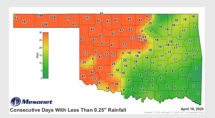
Statewide Discussion: Storms yesterday evening in parts of western and northcentral Oklahoma, bringing both rain and hail, yielded wetting isolated wetting amounts while outside of individual storm cells amounts of less than 0.10” was realized in the band of storms. Northwestern and Panhandle counties remain very dry with separation from a wetting event ranging from 43 days across most of the west to 224 days (7.5 months) in Texas County. Fire danger will remain a daily consideration until wetting moisture overspreads the area. Composite fuel dryness, with reference to Energy Release Component, has been and will remain a daunting factor evidenced in the level of fire’s resistance to control and the demand for extended resource commitment insuring thorough mop up. Less than critical fire weather is required to deliver problematic to extreme fire behavior even with below-normal herbaceous fuel loading.
Fire danger will remain a headline emphasized in the northwestern and Panhandle counties through the remainder of the week and into early next week. On note, Friday is of particular concern ahead of another cold front that pushes near-critical to critical fire weather into northwestern/western Oklahoma and storm chances further east.
Today: The highest fire danger indices will develop across the Oklahoma Panhandle an far northwestern Oklahoma warm, dry and breezy conditions. Rainfall in areas of north-central Oklahoma into the southern Flint Hills will offer a bit of a respite from recent activity while somewhat less intense dryness across the west will offer opportunity to gain containment on recent fires ahead of an expected uptick in fire occurrence later this week.
• Oklahoma Panhandle/Northwest Oklahoma: From Cimarron County across the Panhandle into Harper County and far
northwestern Oklahoma, a wash/rinse/repeat cycle of elevated fire weather continues. Temperature this afternoon in the
upper-70°’s to mid-80°’s under clear skies with relative humidity values 10-23% will yield fine-dead fuel moisture values
at 4% with some 3% observations in the western Panhandle. South winds sustained 12-17 mph with some higher gusts
will drive head fire rates of spread in grass-dominant fuels at 77-115 ft/min with flame lengths 6-11 ft. Fire activity in brush and timber pockets will readily exhibit problematic fire behavior including single/group tree torching and short-range spotting. 1-Hr. fuel moisture values improve into the overnight although winds will remain elevated through the night.
• Along / Northwest of I-44: Areas of rain/hail, and elevated dewpoint temperature holding relative humidity values generally above 30% will calm fuel receptiveness today. Fine-dead fuel moisture will hold in the 6% range (higher further east) as temperate warms into the upper 70°’s under mostly-clear skies. South winds 9-17 mph with some higher gusts will support head fire rates of spread 65-105 ft/min on fully established fires.
• Southeast of I-44: Initial attack activity is expected to be successful given fine-dead fuel moisture values holding around
7% over most of the area as temperature warms into the mid-70°’s with relative humidity values 35-45%. South to
southeast winds 6-13 mph will yield maximum rates of spread in grass fuels to less than 90 ft/min. Timber-litter fuels
remain viable with shading from leaf cover limited. ROS in timber fuels will be around 20 ft/min with somewhat more rapid growth where fuels are aligned with wind and topography.
Near-Term: As was highlighted in the discussion above, fire danger indices in northwestern/western Oklahoma will ratchet up late this week bringing expectation for increased fire occurrence. While significant fire occurrence probability remains limited, initial attack activity and large fire occurrence seems likely. A crescendo in the prefrontal environment leading into the weekend is likely to hold fire danger concern in northwestern Oklahoma into next week following the cold front progged for Friday night.
Burn Bans: Refer to: https://ag.ok.gov/divisions/forestry-services/ for the most current burn ban information and links to specific burn ban proclamations.


