

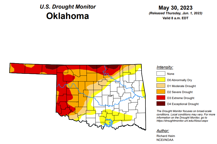
To view the Oklahoma Drought Map, click here.
According to the latest Oklahoma Drought Map, Exceptional drought has improved from last week, moving from 5.68 percent to this week’s 2.7 percent.
Extreme drought or worse has improved slightly, moving from last week’s 25.09 to 24.99 percent.
Severe drought or worse is unchanged from last week’s 43.18.
Moderate drought or worse conditions are also unchanged from last week’s 50.44 percent.
Abnormally dry or worse conditions have worsened from last week, moving from last week’s 60.14 percent to this week’s 62.87 percent.
According to the 6-10-day precipitation outlook map, the majority of central and eastern Oklahoma is leaning above a 33 to 40 percent chance of precipitation through June 10. The panhandle and southwestern Oklahoma are leaning above a 40 to 50 percent chance of precipitation. The far northeast corner stands at a near-normal chance of precipitation.
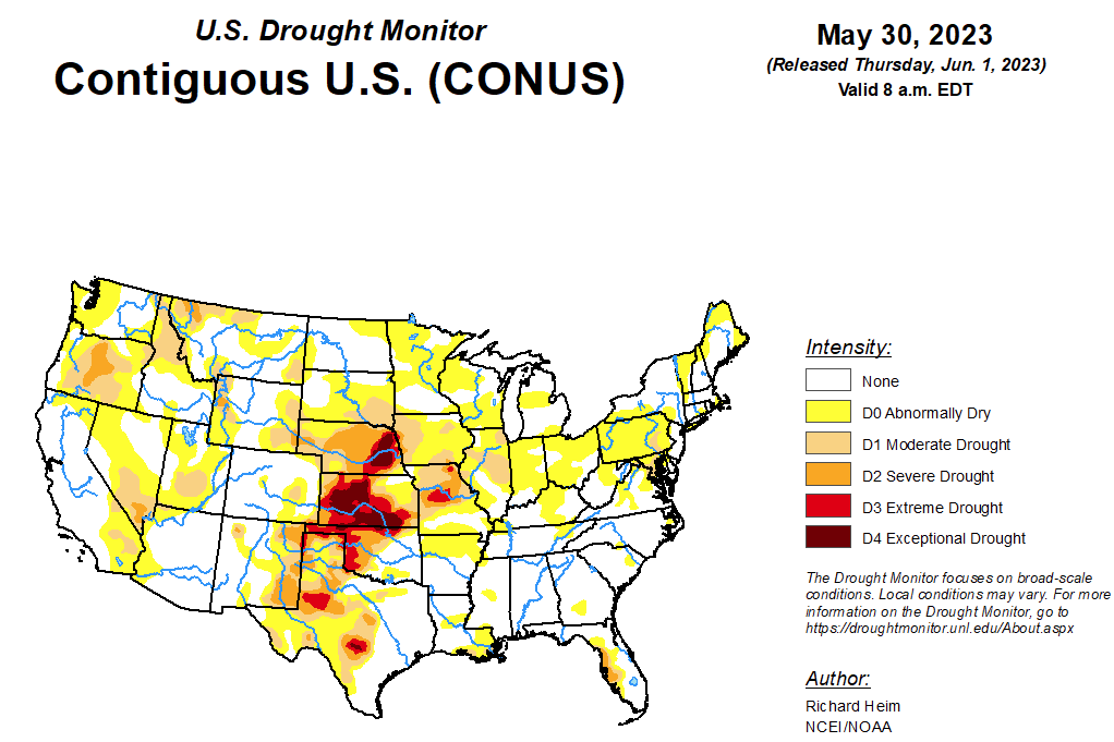
To view the United States Drought Map, click here.
According to the latest U.S. Drought Monitor, the upper-level circulation over the contiguous U.S. (CONUS) during this U.S. Drought Monitor (USDM) week (May 24-30) was dominated by three features: a trough over the West, a ridge that extended from the southern Plains to the Great Lakes, and a cutoff low over the Southeast. This pattern resulted in targeted areas of precipitation, some of it heavy, while large parts of the CONUS received little to no precipitation. Pacific weather systems moved across the West, but their fronts stalled out when they ran into the ridge over the Plains. The northwesterly flow associated with the trough inhibited precipitation across parts of the West, so the week was wetter than normal only from the Great Basin to northern Rockies. A southerly flow over the Plains was created between the western trough and eastern ridge. This flow funneled Gulf of Mexico moisture across the Plains. The moisture fed thunderstorms and weather complexes that developed along the stalled-out fronts and dry lines, resulting in above-normal precipitation across western portions of the Great Plains from Texas to Montana. Several inches of rain fell with some of these thunderstorms, resulting in localized flooding. The ridge inhibited precipitation, so a large part of the country from the Mississippi River to the Northeast received little to no precipitation. The exception to this was the Southeast, where the cutoff low pulled in Gulf and Atlantic moisture to spread above-normal precipitation across much of Florida and the Carolinas to Appalachians. Weekly temperatures averaged cooler than normal from the southern Plains to East Coast, but they were warmer than normal across the northern Plains and northern parts of the West. Abnormal dryness or drought spread across a large part of the Midwest and Northeast, and in parts of the Pacific Northwest, Puerto Rico, and Hawaii. Drought or abnormal dryness contracted across the Florida peninsula, across large areas in the western Great Plains, and in northwest Puerto Rico.
In the Southern Plains, western parts of the South region were wet, while eastern parts were mostly dry. Extreme eastern Tennessee received some rain from the Southeast’s cutoff low, but dry conditions dominated across Arkansas, Louisiana, Mississippi, and Tennessee. D0 expanded in parts of these states. Heavy rain inundated parts of western Texas and Oklahoma, causing contraction of abnormal dryness and moderate (D1) to exceptional (D4) drought. Over 5 inches of rain was recorded at several stations in the Texas panhandle. Soils were wet, streamflow was high, and 6-month precipitation deficits were erased across much of the Texas panhandle. D3 (extreme drought) expanded in Oklahoma just east of where it rained. May 28 USDA data revealed 40% of the winter wheat crop in Texas was in poor to very poor condition.
In the High Plains, locally heavy rain fell over western parts of the High Plains region while eastern parts had a dry week. Several stations in southwest Nebraska received over 5 inches of rain during this USDM week, with 10 inches reported near McCook. The rain replenished soil moisture, but caused extensive flooding. The rain caused a 2-category improvement in drought conditions in southwest Nebraska. Two inches or more of rain fell in localized parts of northeast Colorado, western Kansas, northeast Wyoming, and the western Dakotas, prompting pullback of abnormal dryness or moderate to exceptional drought. But continued dry conditions in the eastern portions of the region resulted in expansion of abnormal dryness or moderate drought in the Dakotas, abnormal dryness to extreme drought in eastern Kansas, and severe to exceptional drought in eastern Nebraska. Based on May 28 USDA data, 69% of the winter wheat crop in Kansas and 51% in Nebraska was in poor to very poor condition, and more than 40% of the topsoil moisture was short or very short in Nebraska (57%), Kansas (50%), and South Dakota (46%). More than two-thirds of the subsoil moisture was short or very short in Nebraska (75%) and Kansas (68%).
In the West, half an inch of rain fell over parts of northern California and from Nevada to the northern Rockies, with much of Montana receiving 2 or more inches. Eastern parts of New Mexico were soaked by 2 to locally over 4 inches of rain, with over 7 inches recorded near Texico. But the rest of the southern third of the West region, and most of Oregon and Washington, received little to no precipitation. D1-D3 were pulled back in eastern New Mexico, and D0-D2 were trimmed in Montana. But D0 expanded in parts of Oregon and Washington where the last 30 days have been unusually warm and dry, soils were drying, and streamflow was decreasing, and D0-D1 expanded in Yellowstone National Park and adjacent southwest Montana. May 28 USDA data revealed 60% of the topsoil moisture in Oregon, 52% in New Mexico, and 48% in Washington was short or very short.
Looking ahead, for June 1-6, an upper-level ridge will dominate the middle part of North America, bringing above-normal temperatures to the north central states and Pacific Northwest. Upper-level troughs and closed lows will cover much of the West and New England, bringing cooler-than-normal temperatures to New England and southern parts of the West to the southern Plains. Like the last 7 days, a southerly flow of Gulf of Mexico moisture will feed showers and storms that develop from the Rockies to the Mississippi River during the next 7 days. An inch or more of rain is forecast from the southern Plains to northern Rockies, with locally 4 inches or more from the Texas panhandle to southern Kansas, and locally 2 inches or more in parts of Colorado to Montana. A fourth of an inch or more can be expected from California’s Sierra Nevada to the Great Basin, across the northern Plains to Mississippi Valley, in the Tennessee Valley, across the Gulf of Mexico coast, and along the Appalachians to Northeast. New England may see over an inch of rain, while much of the Florida peninsula will be inundated with another 2+ inches of rain. Little to no precipitation is predicted for the eastern Great Lakes to Ohio Valley, the interior Southeast, and southern and western portions of the West.
For June 6-14, a warmer-than-normal pattern is likely for the Pacific Northwest to western Great Lakes, the northern half of Alaska, and the Alaska panhandle, with cooler-than-normal temperatures across southern portions of the West, the southern Plains, and from the Appalachians to New England. Odds favor wetter-than-normal conditions across the West, southern Plains, western portions of the central to northern Plains, and the southwest half of Alaska, with drier-than-normal conditions across the Great Lakes, Upper Mississippi Valley, Ohio Valley, and northeast Alaska.
To view the 6-10 Day Precipitation Outlook Map, click here.
To view the 6-10 Day Temperature Outlook Map, click here.
To view the Monthly Drought Outlook Map, click here.


