

Farm Director, KC Sheperd caught up with State Climatologist Gary McManus and talked about conditions in the state of Oklahoma as the state says, “goodbye” to La Niña.
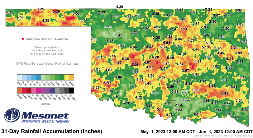
Areas north and west of the I-44 corridor that have missed some good rains, McManus said, are finally seeing some moisture.
“We’ve had these long-term deficits and horrific drought conditions across that part of the state, and they are getting rainfall,” McManus said. “Now, it’s not always the greatest amount of rainfall in all areas due to the convective nature of the thunderstorms that we get. They don’t rain, you know, over a large uniform area. But there are a lot of places across northern and western Oklahoma getting, you know, four or five, six inches of rainfall just through May alone.”
McManus also talked about how those moisture deficits are impacting farmers and ranchers. Long-term impacts, McManus said, include ponds and stock tanks still needing more water to fill.
“By and large, the soil moisture has at least recovered to some degree, enough for planting and enough to get those plants to green up and to get the wheat crop back in shape,” McManus said. “But for those farm ponds and reservoirs, in a lot of cases, are still lacking that good rainfall.”
The start to improved conditions will be getting soil moisture recharged so future rains will run off and fill those ponds, McManus said, but summer heat is approaching quickly.
Last year, for the first ten days of June, McManus said the state received a good amount of rainfall, and the weather was cooler than normal. On June 11, McManus said the rain stopped, and the heat came in.
“It was miserable for months and months all the way through until we passed October, really, when the rain started to come back, and we recovered a little bit,” McManus said. “This year is acting that same way. Of course, we don’t know what the summer is going to do when we get to June 11, to be that exact, or on any other date as we go out further into June, so we don’t have to expect what happened last year to occur again this year, but it is something that we have to keep in mind.”
Rainfall can shut off quickly in an Oklahoma summer, McManus said, and heat can build up fast. La Niña has ended, he added, and as the months progress, the strength of El Niño will be more evident. El Niño strengthens the subtropical Jetstream, McManus said, which allows for storm systems to come across with more moisture and energy.
“It does lead to wetter than normal conditions for much of Oklahoma,” McManus said. “There is a little bit of a caveat there. If you have the weak to moderate El Niño, it can mean drier than normal conditions, if you just look at the average overall. So, we certainly want that to be stronger, or in the super strong category.”
Even if an El Niño is in a stronger category, McManus said the moisture an area receives depends on many different factors coming together.
“At the very least, it is not La Niña, which does tend to bring us drier and warmer than normal conditions, which is really what we have seen in the last three cool seasons here in Oklahoma,” McManus said.
Regarding wheat harvest, McManus said he has heard of some wheat being harvested earlier than normal.
“At least for the next week, it does look like we are going to have a lot of moisture, especially across the far western counties,” McManus said. “Of course, there is not a lot of wheat left in some of those counties to even harvest, but as we get over into the central part of the state, it looks a little bit more on the drier side.”
There is still some moisture in that central part of the state, McManus said, just not as much as others.


