

According to the Oklahoma Mesonet, the Climate Prediction Center has issued an “El Nino Advisory,” which means that El Nino conditions have been observed and are expected to continue. Recent rains the state has received don’t have anything to do with El Nino, said State Climatologist Gary McManus.
To have a full El Nino declaration, McManus said many more factors will need to come into play.
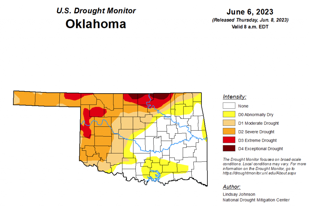
To view the Oklahoma Drought Map, click here.
According to the latest Oklahoma Drought Map, Exceptional drought has improved again this week, now at 1.45 percent. (Last week was at 2.7 percent.)
Extreme drought or worse has improved significantly, moving from last week’s 24.9 percent to this week’ 9 percent.
Severe drought or worse has improved as well, moving from last week’s 43.18 percent to this week’s 35.72 percent.
Moderate drought or worse has worsened slightly, moving from last week’s 50.44 to this week’s 50.56 percent.
Abnormally dry or worse conditions have also worsened, moving from last week’s 62.87 percent to this week’s 64.59 percent.
According to the 6-to-10-day precipitation outlook map, the majority of the state is standing at a near-normal chance of precipitation through June 17. The northern border of the state, especially the northeast corner, is learning above a 33 to 40 percent chance of precipitation. The far southwest corner of the state is leaning below a 33 to 40 percent chance of precipitation through that June 17 date.
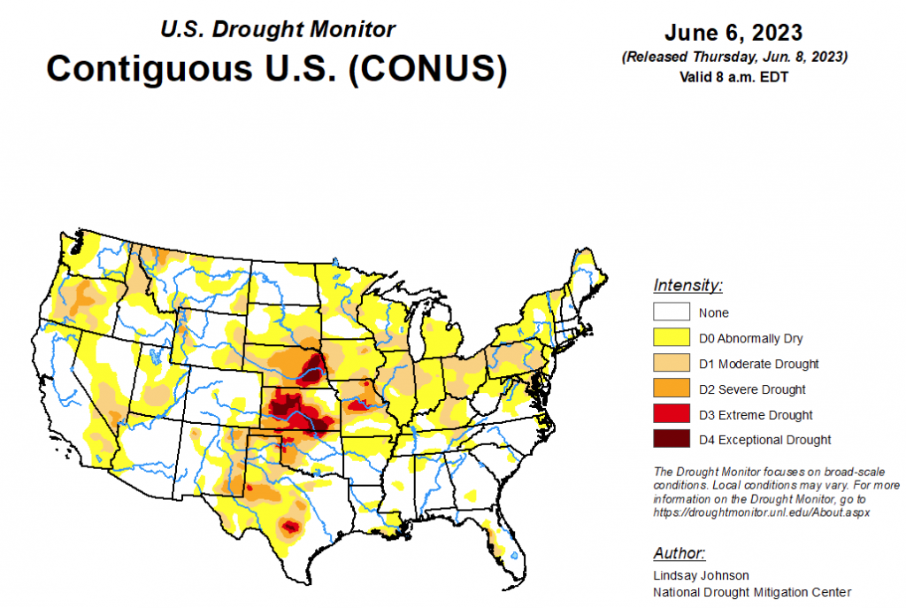
To view the United States Drought Map, click here.
According to the latest U.S. drought monitor report, heavy rains fell this week across some of the western parts of the Central and Southern Great Plains, especially in the Texas Panhandle and western Oklahoma and Kansas, leading to widespread improvements to ongoing drought in the western Great Plains. Heavy rains in the central and southern Florida Peninsula also led to improvements to ongoing drought and abnormal dryness in the southwest Florida Peninsula. Widespread degradations occurred in the Midwest and western portions of the Northeast, amid very dry and warm recent weather. In the West, some minor improvements occurred in parts of Nevada, Utah and Idaho, where high streamflows and large precipitation amounts from the winter into May led to a reassessment of conditions. Degradations were made in a few parts of western Montana and northwest Washington, where precipitation deficits mounted amid declining soil moisture and streamflow.
In the Southern Plains, relatively dry weather occurred this week in Arkansas, Tennessee, Mississippi and east-central and northeast Oklahoma. Farther west, in the Texas Panhandle, northwest Oklahoma and the eastern Oklahoma Panhandle, the recent wet pattern continued, and widespread 2- to 5-inch rains fell, with localized higher amounts. Widespread improvements were made to the drought and dryness depiction in this region, where soil moisture improved and precipitation deficits lessened. The rest of Texas saw a mixture of a few improvements and degradations, as heavier precipitation amounts around the state were more spotty. Farther east in eastern Oklahoma and northern Arkansas, abnormal dryness and moderate drought were introduced or expanded in areas that have recently seen growing short-term precipitation deficits, declines in soil moisture, and lowering streamflows.
In the High Plains, heavy rains fell over parts of the Colorado, Kansas, Nebraska and southeast Wyoming plains again this week, leading to widespread one-category improvements in areas with increasing soil moisture and lessening precipitation deficits. After recent heavy rains, some improvements were also made in northeast and east-central Kansas. In eastern Nebraska, some heavier rains fell, but these were quite spotty, so drought areas remained mostly unchanged. Conditions improved in a small area southeast of Lincoln where rainfall amounts locally exceeded 4 inches. North of Omaha, extreme drought expanded slightly, as soil moisture and precipitation deficits worsened alongside poor streamflow. During May, Lincoln and Omaha both received much less than an inch of rainfall, and much of Saunders County received less than an inch of rain as well. Omaha’s May total of 0.17 inches of rain came in as the driest May on record there. In South Dakota, moderate and severe drought increased in coverage in the southeast, where short-term precipitation deficits mounted amid decreased streamflow and soil moisture. Rolling corn was reported north of Mitchell, and very dry soils were reported in far southeast South Dakota, where impacts to agriculture and need for irrigation are quickly ramping up.
In the West, small-scale improvements were made in parts of southern and central Idaho, Nevada and northwest Utah, where high streamflows and large precipitation amounts from the winter into May led to a reassessment of conditions. Moderate and severe drought increased in coverage in northwest Montana and northwest Washington, where short-term precipitation deficits were occurring amidst low streamflow and decreasing soil moisture. In Oregon, a tight gradient in temperature and precipitation anomalies has been present recently, resulting in worsening conditions in the north and west portions of the state, while conditions have improved in the southeast part of Oregon. In some areas, streamflow and snow cover has quickly decreased as a result of early melt off and recent dry weather. Due to heavy rains associated with a storm system responsible for the heavy rain in the southern Great Plains, some improvements were also made in the plains of east-central New Mexico.
Looking ahead, for June 8-13, an inch or more of rain is forecast from the Pacific Northwest to the western interior, then across the central Plains, northern parts of the Southeast, and much of the Midwest. Local amounts up to or exceeding 3 inches of rain is forecast in northern and central Montana and the northern Rockies of Colorado. Far southern Florida may also see an inch or so of rain during this period. A quarter inch or more can be expected in the northern Plains into the western Midwest, the Northeast and the South from Texas to Florida. Little to no precipitation is predicted for the lower four-corners area and Pacific West Coast.
For the period from June 13-17, the National Weather Service Climate Prediction Center forecast favors below-normal precipitation across parts of the south-central and southeast United States, especially the central and western Gulf Coast areas into southwest Texas and southern New Mexico. Above-normal precipitation is favored in the Intermountain West and Great Basin, and with lesser confidence also favored from the Central Great Plains eastward into the Ohio Valley, Mid-Atlantic, and Northeast. Below-normal precipitation is favored in the Great Lakes vicinity. Above-normal precipitation is favored in most of Alaska, with the exception of the far southern reaches of the southeast Panhandle, where below-normal precipitation is more likely. Temperatures in Alaska are likely to be below normal in most areas, excluding the far north, with the highest forecast confidence centered over south-central and southeast Alaska. In the Lower 48, cooler-than-normal temperatures are favored in the Southwest and Intermountain West, excluding southeast New Mexico, and in the Upper Ohio River Valley. Warmer-than-normal temperatures are more likely in the north-central and northwest United States, especially in Minnesota and surrounding states, and from Texas and Oklahoma southeast into southern Alabama and Georgia and all of Florida.
To view the 6-10 Day Precipitation Outlook Map, click here.
To view the 6-10 Day Temperature Outlook Map, click here.
To view the Monthly Drought Outlook Map, click here.


