

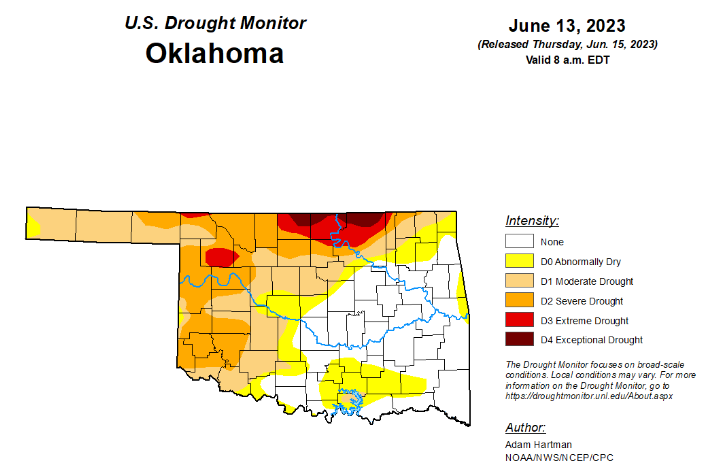
To view the Oklahoma Drought Map, click here.
According to the latest Oklahoma drought monitor, Exceptional drought is unchanged from last week at 1.45 percent.
Extreme drought or worse has improved from last week’s 9 percent and is now at 5.85 percent.
Severe drought or worse has improved significantly from last week, moving from 35.72 percent to 25.38 percent this week.
Moderate drought or worse improved slightly from last week’s 50.56 percent and is now at 49.25 percent.
Abnormally dry or worse conditions worsened slightly, moving from last week’s 64.59 percent to this week’s 65.01 percent.
According to the 6-10-day precipitation outlook map, the panhandle through central Oklahoma is leaning above a 33 to 40 percent chance of precipitation through June 24. The remaining part of the state, further east, including the northeast corner and southeast corner, is standing at a near-normal chance of precipitation through that date.
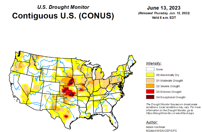
To view the United States Drought Map, click here.
According to the latest U.S. drought monitor, above normal precipitation and below normal temperatures resulted in another week of targeted improvements across portions of the Intermountain West, adding to recent precipitation totals that have continued to improve long-term drought conditions. The exception is the Pacific Northwest, where below normal precipitation and above normal temperatures resulted in worsening drought conditions along the northern Cascades. There is a mix of improving and worsening drought conditions across the Great Plains. Improvements are mainly confined to the western Great Plains, where widespread 7-day rainfall totals exceeded 200 percent of average for the week, further adding to short-term precipitation surpluses. From the eastern Great Plains to the Eastern Seaboard, 7-day rainfall surpluses are more scattered in nature, leading to only modest improvements in areas seeing the heaviest amounts. In areas that received below normal rainfall this week, drought worsened, as rainfall deficits continue to increase.
In the Southern Plains, several locations across Louisiana, Mississippi, and Tennessee experienced degradation this week, as the frontal boundary draped across the southern tier states did not result in enough precipitation to stave off degradation for those experiencing antecedent dryness. This is also the case in portions of central Texas and parts of the middle Red River basin, where targeted degradations are also warranted. However, farther westward across western portions of the Southern Plains, pockets of heavy rainfall continued to add to 60-day precipitation surpluses, particularly for parts of the Texas and Oklahoma Panhandles. Rainfall has been plentiful in these areas in recent weeks and months. For example, Amarillo Texas recently set a new record of 20 days with measurable precipitation during May; the previous record being 15 days. In addition, Lake Meredith, located north of Amarillo has reached 45.8 percent of its capacity, its highest since 2001, according to Texas Water Development Board data.
In the High Plains, although much of the High Plains region received above-normal precipitation this week, the region as a whole is a tale of 2 halves. Improvement to the drought depiction is warranted across western portions of the Central and Northern Plains, where 7-day precipitation totals exceeded 200 percent of average across most areas, adding to precipitation surpluses in recent weeks and improving long-term drought indicators. Conversely, deteriorating conditions are warranted across eastern parts of the High Plains region where heavy, convective rainfall was not enough to overcome predominantly near and above normal temperatures and high rates of evaporation from the soils and vegetation (known as evapotranspiration). For example, parts of South Dakota reported evapotranspiration rates from crops averaging around 0.25 inches per day, which varied slightly depending on the type of crop, essentially eliminating the effects of beneficial rainfall for several locations.
In the West, the Intermountain West is the beneficiary of another week of widespread above normal precipitation for many locations, with large portions of the Four Corners region, the Great Basin, and the southern and central Rockies also experiencing below normal temperatures. Improvements are warranted in locations where long-term drought indicators, such as groundwater, continue to improve. In addition, the above-normal snowpack from the active winter rainy season across much of the West continues to keep stream flows near and above average. Unfortunately, degradations are warranted across parts of the Cascades in the Pacific Northwest, which experienced a near- to below-average winter rainy season, which has been exacerbated by below average precipitation since that time. Soil moisture and groundwater continue to decline and 7 to 14 day average stream flows have fallen into the bottom 30 percent (and in many cases, the bottom 10 percent) of their historical distributions. In addition, above average temperatures this week (4 to 10°F above normal) have acted to accelerate this deterioration.
Looking ahead, according to the Weather Prediction Center, over the next 6 days (June 15 – 20) warm temperatures are forecast to build across central portions of the lower 48 states, with cooler temperatures forecast across much of the Intermountain West and the West Coast leading up to June 20. Generally seasonal temperatures are likely east of the Mississippi River. Rainfall is forecast across a large swath of the lower 48 states from the Pacific Northwest to the Southeast, and northward along the East Coast. In the Southeast, heavy precipitation (in excess of 5 inches) is forecast for parts of the Deep South and the central and eastern Gulf Coast region.
During the next 6 to 10 days (June 20 – 24), the Climate Prediction Center favors below normal temperatures across the western third of the lower 48 states, and across parts of the Mid-Atlantic coast and Appalachians. Above normal temperatures are favored for the Great Plains, Mississippi River Valley, Great Lakes, interior Northeast, and southern Florida. Above normal precipitation is indicated across northwestern and north-central portions of the lower 48 states, and across the Southeast and Mid-Atlantic states. Below normal precipitation is weakly favored across parts of southern Texas and extending into the Four Corners region, parts of the Midwest, and northern New England.
To view the 6-10 Day Precipitation Outlook Map, click here.
To view the 6-10 Day Temperature Outlook Map, click here.
To view the Monthly Drought Outlook Map, click here.


