

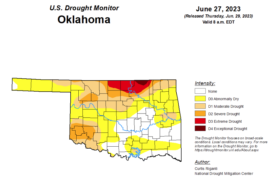
To view the Oklahoma Drought Map, click here.
According to the latest Oklahoma drought monitor, exceptional drought is unchanged from last week at .52 percent.
Extreme drought or worse is also unchanged from last week at 4.79 percent.
Severe drought or worse has improved from last week’s 16.59 percent and is now at 14.26 percent.
Moderate drought or worse has improved from last week’s 41.91 percent and is now at 36.08 percent.
Abnormally dry or worse conditions have worsened since last week, moving from 73.21 percent to 76.94 percent.
According to the 6-10-day precipitation outlook map, the entire state is leaning above a 40 to 50 percent chance of precipitation through July 8.
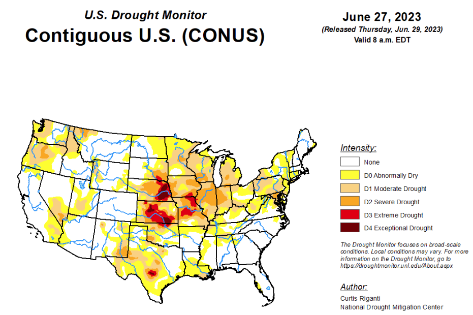
To view the United States Drought Map, click here.
According to the latest U.S. drought monitor, widespread changes were made across the country, with many degradations and improvements occurring. In the eastern U.S., mostly widespread improvements occurred following widespread heavy rains, though parts of New Jersey and Long Island that missed out on these rains saw conditions worsen. The Midwest and east-central Great Plains saw mostly worsening conditions and widespread crop stress and low streamflows after another week of mostly dry weather. A mix of improvements and degradations occurred in Texas, where recent precipitation amounts have varied widely. The northern Great Plains received widespread heavy rainfall this week, leading to large-scale improvements to ongoing drought and abnormal dryness. In the Pacific Northwest, a few areas saw above-normal precipitation and improving conditions, but larger parts of the region saw increasing evaporative demand, continued dry weather and lowering streamflows, leading to worsening conditions.
In the Southern Plains, much warmer than normal temperatures covered the western half of the region, especially across southwest Texas, where temperatures were at least 9 degrees above normal in many locations. Farther east, temperatures were near normal or cooler than normal, with readings coming in from 3 to 6 degrees below normal in eastern Tennessee. Recent rains in central Louisiana led to a shifting of a small area of moderate drought as short-term precipitation deficits shifted to the northeast. Short-term moderate drought developed in parts of northeast Arkansas and eastern Oklahoma, where short-term precipitation deficits grew and streamflow decreased. In north-central, central and southeast Texas, soil moisture and streamflow decreased amid growing precipitation deficits, leading to localized worsening in drought conditions or introduction of abnormal dryness. Farther west in Texas, a combination of precipitation this week and a re-evaluation of precipitation from recent weeks led to more improvements in the Texas Panhandle and in adjacent western Oklahoma, as well as improvements in a severe drought area south of Lubbock.
In the High Plains, this week’s weather varied substantially across the High Plains region. Much of the Great Plains portion of the region, with the exception of eastern Nebraska and eastern Kansas, saw widespread precipitation, some of it heavy. Much of northwest Nebraska, eastern Wyoming, northeast Colorado, South Dakota and the southern half of North Dakota saw rainfall of at least 2 inches over the last week. In western Nebraska, eastern Wyoming and the Dakotas, this led to widespread improvements to the drought depiction in areas where the heaviest rains fell. Isolated heavy rains in central and western Kansas also led to localized improvements to ongoing drought areas. Meanwhile, conditions continued to worsen in southeast Nebraska, northeast Kansas and the Kansas City area, where mostly dry weather continued. Given continued decreases in soil moisture and groundwater, and growing short- and long-term precipitation deficits, exceptional drought was introduced in parts of the Omaha metropolitan area. North of Lincoln, Nebraska, hay production was reported to be about a third of normal for this time of year. Stress to other vegetation, including trees, also continued in southeast Nebraska this week.
In the West, with the exception of western portions of Washington and Oregon, much of the West region experienced near- or cooler-than-normal temperatures this week. Heavy rains fell in parts of southeast Montana, northwest Wyoming and adjacent portions of central Idaho and southwest Montana. These rains helped to alleviate long-term precipitation deficits and increase streamflows in these areas, leading to a reduction in coverage of ongoing drought and abnormal dryness. Adjacent to improvements in the Texas Panhandle, recent precipitation in northeast New Mexico has also helped to improve conditions there. Continued above-normal precipitation in parts of central and south-central Oregon has helped to alleviate long-term precipitation deficits and increase soil moisture, leading to localized shrinking of drought coverage. In southeastern and western portions of Washington, and in western Oregon, recent dry weather, low streamflows and increasing evaporative demand led to an expansion of drought and abnormal dryness in parts of these areas.
Looking ahead, through the evening of Monday, July 3, the National Weather Service Weather Prediction Center is forecasting widespread rain, locally heavy, to fall from southeast Wyoming and northeast Colorado eastward across Nebraska and northern Kansas, southern Iowa and northern Missouri, and farther east into the Midwest and Ohio River Valley. Rainfall amounts in central Illinois may exceed 3 inches locally. Widespread moderate and locally heavy rainfall amounts are forecast in parts of the Appalachian Mountains as well. Locally heavy rains are forecast in southern Florida during this period as well. West of the Continental Divide, mostly dry weather is expected.
Looking ahead to the period from July 4-8, the National Weather Service Climate Prediction Center forecast favors above-normal precipitation across much of the contiguous U.S., especially from eastern Idaho through Nebraska and northern Kansas. Below-normal precipitation is favored in Arizona and in western Washington and northwest Oregon. Below- or near-normal temperatures are favored in the northwestern Great Plains, while above-normal temperatures are likely in the south-central U.S., south Florida and the eastern Great Lakes, with warmer-than-normal temperatures slightly favored across much of the eastern and southern U.S., excluding southern California and the southern Appalachians. Warmer-than-normal temperatures are also strongly favored in the Pacific Northwest. Wetter-than-normal weather is favored across Alaska, except for the Panhandle, where below-normal rainfall is slightly favored. Warmer-than-normal temperatures are slightly favored in the north slope and Arctic Coast regions of Alaska, and in the far southeastern Alaska Panhandle. Cooler-than-normal conditions are favored across roughly the southwestern half of Alaska.
To view the 6-10 Day Precipitation Outlook Map, click here.
To view the 6-10 Day Temperature Outlook Map, click here.
To view the Monthly Drought Outlook Map, click here.


