

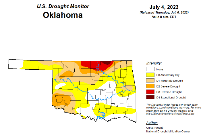
To view the Oklahoma Drought Map, click here.
According to the latest Oklahoma drought monitor, exceptional drought remains unchanged from the past two weeks at .52 percent.
Extreme drought or worse is also unchanged from the past two weeks at 4.79 percent.
Severe drought or worse is unchanged from last week at 14.26 percent.
Moderate drought or worse has improved slightly, moving from last week’s 36.08 percent to 35.88 percent this week.
Abnormally dry or worse conditions have improved since last week, moving from 76.94 percent to this week’s 73.77 percent.
According to the 6-10-day precipitation outlook map, a pretty good-sized strip of the southern border, into southwestern Oklahoma and the western side of the panhandle stands at a near normal precipitation through July 15. The rest of the state, which consists of central Oklahoma and further north is leaning above a 33 to 40 percent chance of precipitation though that July 15 date.
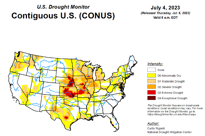
To view the United States Drought Map, click here.
According to the latest U.S drought monitor, heavy rains fell this week across parts of the Midwest, Ohio River Valley and Northeast, which led to widespread improvements from southeast Nebraska to central Illinois, southern Indiana, and central and eastern Kentucky. To the south and west, in southern Missouri, the Texas-Louisiana border and other parts of central Texas, drier weather led to worsening precipitation deficits, and significant problems with hay production in parts of southern Missouri. Dry weather in the Upper Midwest led to further degrading conditions in parts of Michigan, Wisconsin and Minnesota. A re-evaluation of conditions in parts of the western Great Plains led to some improvements to long-term dryness and long-term moderate drought in the Texas and Oklahoma Panhandle region, and in western Nebraska and eastern Wyoming, respectively. A mix of degradations and improvements occurred in the Pacific Northwest. No changes were made to the USDM depictions this week outside of the Lower 48.
In the Southern Plains, much warmer-than-normal temperatures covered the South as it is enveloped in the continuing heat wave, especially eastern Texas and Louisiana where temperatures ranged from 4 to 8 degrees above normal compared to the rest of the region where temperatures were near normal to 4 degrees above normal. There was expansion of abnormal dryness and moderate drought along the western Gulf Coast where temperatures soared and little to no precipitation fell, providing no relief to the low streamflows and dry soil conditions. Tennessee did see the removal of moderate drought conditions along the Tennessee-Kentucky border after heavy rainfall. Conditions were status quo for the rest of the region despite seeing warmer-than-normal temperatures and slightly below-normal precipitation this last week.
In the High Plains, this week saw widespread improvements across the Great Plains. Much of the Great Plains portion of the region, with the exception of eastern Kansas, northern North Dakota and western Colorado, saw widespread precipitation, some of it heavy. Much of southeast and northwest Nebraska, northeast South Dakota and along the Wyoming-South Dakota border saw rainfall of at least 2 inches over the last week. In western Nebraska, eastern Wyoming and the Dakotas, this led to widespread improvements to the drought depiction in areas where the heaviest rains fell. Nebraska saw the most improvements in the High Plains with continued improvement in the Panhandle, the Sandhills up to the South Dakota border and the southeast near Nebraska City. Meanwhile, conditions continued to worsen in a majority of Kansas, particularly in the east and southeast where mostly dry weather continued. Given continued decreases in soil moisture and groundwater, and growing short- and long-term precipitation deficits, degradations were made from Manhattan to Fort Scott.
In the West, with the exception of western portions of Washington and Oregon, much of the West region experienced near- or cooler-than-normal temperatures this week. Heavy rains fell in parts of southeast Montana, northwest Wyoming and adjacent portions of central Idaho and southwest Montana. These rains helped to alleviate long-term precipitation deficits and increase streamflows in these areas, leading to a reduction in coverage of ongoing drought and abnormal dryness. Continued above-normal precipitation in parts of central and south-central Oregon has helped to alleviate long-term precipitation deficits and increase soil moisture, leading to localized shrinking of drought coverage. In southeastern and western portions of Washington, and in western Oregon, recent dry weather, low streamflows and increasing evaporative demand led to an expansion of drought and abnormal dryness in parts of these areas.
Looking ahead, the National Weather Service Weather Prediction Center forecast (valid July 5–7, 2023) calls for the latest heat wave in the Pacific Northwest to reach its peak intensity on Wednesday, July 5, with temperatures topping the lower 100s in the hottest locations. Excessive heat warnings and heat advisories coincide with many areas designated as abnormally dry or moderate drought. The heat is expected to taper off moving into the weekend. Farther south, hot, dry and windy conditions support an Excessive Heat Warning in southern Arizona and a Critical Fire Risk designation in northern Arizona, which overlaps areas of moderate drought. Showers and thunderstorms are expected to bring periods of heavy to excessive rainfall to drought-affected areas of the Central Plains and Midwest. Scattered thunderstorms are expected to linger across the southern tier of states. As a reminder, weather within this timeframe is after the data cutoff for this week and will be reflected on next week’s map. Heading into the weekend, the extended forecast (valid July 7–11, 2023) calls for hazardous heat across portions of California, the Southwest, the Southern Rockies, the South and the Southeast. This expected multi-day heat wave could worsen existing drought conditions in these regions. Showers and thunderstorms are forecast for portions of the Central Plains, Midwest and South. Whether these rains will be beneficial and help ease drought concerns in these areas remains to be seen. While thunderstorms can produce large amounts of precipitation in a very short time, most of the rain runs off into drainage channels and streams. On the other hand, rain falling as light to moderate showers soaks into the ground, helps to recharge groundwater, sustains vegetation, and begins to chip away at moisture deficits that have built up during drought.
Next week, the Climate Prediction Center’s 6- to 10-day outlook (valid July 12–18, 2023) calls for an increased probability that the observed temperature, averaged over this 7-day period, will be above normal across the Southern Plains, much of the West, the Southeast and the Northeast. South Texas and South Florida have an 80–90% chance that the average temperature will be above normal during this period. In general, the odds of a warmer-than-normal average temperature decrease moving northward. The odds that the observed temperature, averaged over the same 7-day period, will be cooler than normal are highest in the Midwest (33–50%). Below-normal precipitation probabilities are increased across parts of the Southern Plains, Nevada and the Four Corners Region. Utah has a 50–60% chance that the total precipitation over the 7-day period will be below normal. Meanwhile, the Midwest has the highest probability (40-50%) that observed precipitation totals will be above normal. Other areas with an increased probability of above-normal precipitation include parts of the Pacific Northwest, northern Plains, Midwest and Northeast.
To view the 6-10 Day Precipitation Outlook Map, click here.
To view the 6-10 Day Temperature Outlook Map, click here.
To view the Monthly Drought Outlook Map, click here.


