

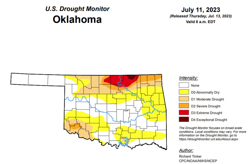
To view the Oklahoma Drought Map, click here.
According to the latest Oklahoma drought monitor, exceptional drought has moved from 0.52 to 0.42 percent since last week.
Extreme drought or worse has improved slightly, moving from last week’s 4.79 percent to this week’s 4.20 percent.
Severe drought or worse has improved greatly, moving from 14.26 percent last week to 9.12 percent this week.
Moderate drought or worse has improved as well, moving from last week’s 35.88 percent to this week’s 23.63 percent.
Abnormally dry or worse conditions saw significant improvements, moving from last week’s 73.77 percent to this week’s 56.96 percent.
According to the 6-10-day precipitation outlook map, the majority of the state, aside from the southern strip of the border, is at a near-normal chance of precipitation through July 22. As for the southern border, that portion of the state is leaning below a 33-40 percent chance of precipitation through that July 22 date.
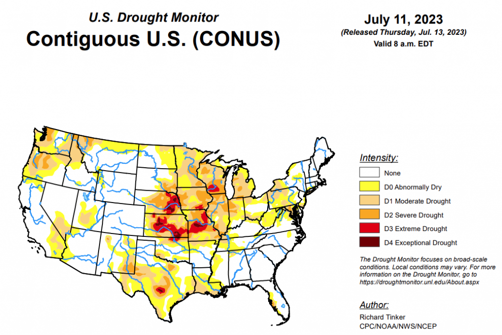
To view the United States Drought Map, click here.
According to the latest U.S. drought monitor, heavy to excessive rainfall significantly improved or removed drought from parts of the Northeast and south-central Great Plains. The heaviest amounts fell in a broken pattern from lower New York through Vermont, and in a swath from central Oklahoma through the fringes of the Texas and Oklahoma Panhandles. Many of these areas recorded over 6 inches of rain, with totals approaching 9 inches in a few isolated spots. Lesser but still heavy amounts exceeding 3 inches fell on portions of the central Plains, Texas Gulf Coast, lower Mississippi Valley, interior Southeast, Carolina Coastline, and upper Great Lakes Region, allowing drought to ease in some of these areas. In contrast, other parts of Texas, the middle and upper Mississippi Valley, the lower Great Lakes, and the central and northern Dakotas received only several tenths of an inch of precipitation at best, resulting in several areas of deepening drought. Hot weather from the desert Southwest through the southern Plains and across Florida exacerbated drought conditions there. West of the Rockies, seasonably dry conditions prevailed.
In the Southern Plains, highly variable condition were noted across this region. Heavy to excessive rainfall triggered some flooding in an area from the Texas and Oklahoma Panhandles southeastward through northeastern Texas, with several locations in central Oklahoma reporting 7 to locally near 10 inches of rainfall. Existing dryness in this area was eliminated or at least greatly improved. Meanwhile, most of interior and western Texas saw little if any rainfall, prompting expansion and intensification of dryness and drought there. In addition, much of northern Arkansas and adjacent Oklahoma reported only light rainfall at best, allowing expansion and intensification of D0 to D2 conditions across this area Other parts of the South were covered by a broken pattern of moderate to heavy rainfall, with a few locales reporting over 3 inches of rain. Scattered areas of improvement were noted through these regions.
In the High Plains, heavy rainfall soaked much of south-central and southwestern Kansas, with 4 to locally 8 inches observed in many areas. Significant drought reduction resulted, although some degree of longer-term dryness remained in most locations. Eastern Nebraska, southeastern South Dakota, eastern Colorado, and a few other parts of Kansas received moderate to locally heavy rains, prompting substantial if less-widespread improvement in those areas. In addition, parts of Wyoming continued to benefit from the exceptionally wet and (in higher elevations) snowy winter, so D0 and D1 areas were again whittled down slightly. In contrast, moderate drought (D1) expanded in both the northwestern and northeastern sections of North Dakota, where persistently below-normal precipitation has been observed for the past few months. Although more improvement than deterioration occurred last week, exceptional drought (D4) remained over parts of southeastern Kansas, portions of west-central and north-central Kansas, and a few patches in eastern Nebraska.
In the West, scattered light to moderate precipitation fell on parts of the southern half of Montana, eastern New Mexico, and isolated sites in the northern Intermountain West. Highly isolated amounts of no more than 0.2 inch were observed elsewhere, with most locations reporting no measurable precipitation. Growing moisture deficits led to areas of drought expansion and intensification across Washington and Oregon, a portion of northernmost Idaho, and parts of northern Montana. Farther south, despite the dry week, the exceptionally wet and snowy winter continued to benefit much of Utah, the Great Basin, and the desert Southwest. D2 was removed from southern Nevada, and areas of D0 and D1 were reduced in size. In the West Region, there is no longer any D2 to the south and east of central Oregon.
Looking ahead, according to the Weather Prediction Center (WPC), over the next 5 days (July 13 – 17) heavy precipitation is expected across Missouri and adjacent areas, where some of the most acute rainfall deficits have been observed recently. Amounts of 1.5 to locally over 3.0 inches are expected. Similarly heavy rains are anticipated in the eastern Lower Mississippi Valley, the central Appalachians, the southeastern Great Lakes Region, much of New England and the adjacent Northeast, parts of the mid-Atlantic Region, and southern Florida. Additional flooding is possible in portions of New England. Light to locally moderate rain is anticipated in most other locations east of the Mississippi River and across the central and south-central Great Plains. In contrast, most of Texas should see little if any precipitation, and seasonable dryness is expected west of the Rockies. Hot weather is anticipated along the southern tier of the country from the desert Southwest eastward through much of Florida, especially later in the period.
During the ensuing 5 days (July 18 – 22), the Climate Prediction Center (CPC) favors above normal temperatures across most of the contiguous 48 states, with odds leaning toward near or slightly below normal temperatures only in most of Washington, and in a swath from the northern Plain eastward across the upper Midwest and northern Appalachians through the lower Northeast. Dry weather is favored to continue across Texas and in most of the Intermountain West and Northwest. Increasing monsoonal activity is expected in southern Arizona and adjacent areas, where odds slightly favor above-normal precipitation. A slight tilt of the odds toward wetter than normal weather also covers the central and northern Plains, the Northeast and adjacent mid-Atlantic Region, and southern Florida.
To view the 6-10 Day Precipitation Outlook Map, click here.
To view the 6-10 Day Temperature Outlook Map, click here.
To view the Monthly Drought Outlook Map, click here.


