Its been a HOT July in Oklahoma, but According to State Climatologist Gary McManus relief is coming and bringing with it a chance of rain, ” Rain chances should come back as early as Thursday up north, and spreading to the south as we get into the weekend. Maybe not as monumental as we saw in July, but enough to keep the clouds around and the dust settled.”
We did see quite a bit of Rain throughout July, which is not typical for Oklahoma, “The unusually wet and mild weather Oklahoma enjoyed through much of May and June continued into July, providing the state with uncharacteristic summertime drought relief. The Southern Plains heat dome still managed to meander its way However, over Oklahoma for short periods, basting the state in intense heat and stifling humidity.”
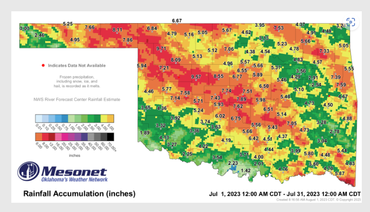
In fact the rainfall in July did set a few records according to McManus, ” The statewide average rainfall total for the month was 5.19 inches, 1.99 inches above normal and ranked as the 13th wettest July since records began in 1895. Nearly the entire state finished the month with a surplus, save for localized areas across far southern and northern Oklahoma where deficits of up to an inch were reported. The surplus rain totals from the eastern Panhandle through central Oklahoma were tremendous, however, at 3-7 inches above normal. Each of the 10 highest July rainfall totals were at Mesonet sites within that swath, from Woodward’s 9.71 inches to Norman’s 7.62 inches. The Panhandle, west central, and central Oklahoma all enjoyed top 10 wettest July rankings of sixth, third, and seventh, respectively. Sixty-one of the Mesonet’s 120 sites recorded at least 5 inches of rain for the month, and another 31 saw at least 4 inches. Burneyville in far south central Oklahoma reported the lowest total at 1.42 inches. Grandfield and Hollis also received less than two inches during July at 1.94 and 1.89 inches, respectively. The January-July statewide average of 22.83 inches was 0.81 inches above normal and ranked as the 43rd wettest such period on record.”
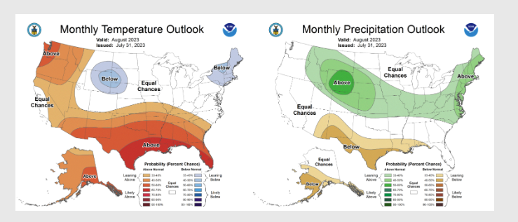
Thanks to the timely rains drought coverage in Oklahoma Dropped throughout the state from 36: a the end of June to around 18% at the end of July, ” Still, those regions remained in severe to extreme drought, exacerbated by longer-term deficits that stretch back to August 2021 and amplified by the summer of 2022’s disastrous flash drought. The Climate Prediction Center’s August outlooks show increased odds for above normal temperatures across the entire state, and above normal precipitation across far north central Oklahoma. CPC’s corresponding August drought outlook sees it being relieved—and partially eradicated—across the area of drought in northern Oklahoma, but persisting across far southwestern sections of the state. However, no new areas of drought are expected to develop through August.”