

To view the Oklahoma Drought Map, click here.
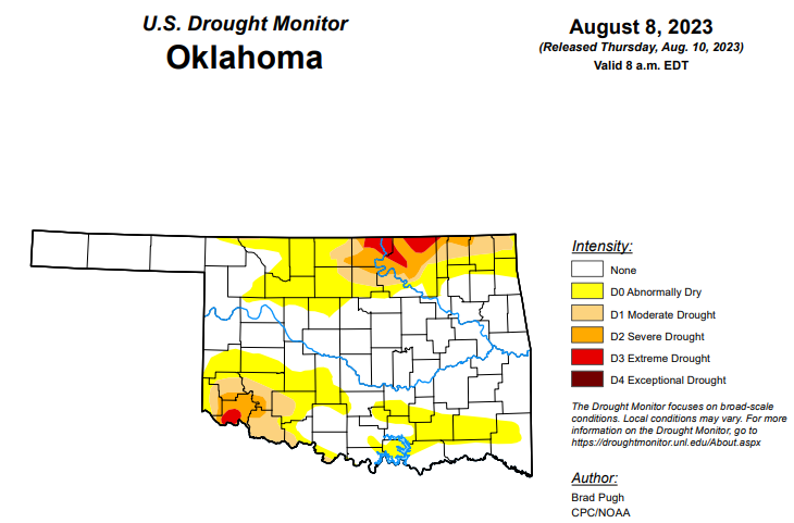
According to the latest Oklahoma Drought Monitor, exceptional drought remains at zero percent, unchanged from the past few weeks.
Extreme drought or worse improved from last week’s 2.58 and is now at 1.60 percent this week.
Severe drought or worse has improved from last week’s 7.58 percent and is now at 5.84 percent this week.
Moderate drought or worse has improved from last week’s 17.90 percent and is now at 12.81 percent this week.
Abnormally dry or worse conditions have improved from last week’s 47.67 percent and are now at 37.75 percent this week.
According to the 6-to-10-day precipitation outlook map, the entire state, aside from the northeast corner, is leaning below a 33 to 40 percent chance of precipitation through August 19. The northeast corner stands at a near-normal chance of precipitation through that date.
To view the United States Drought Map, click here.
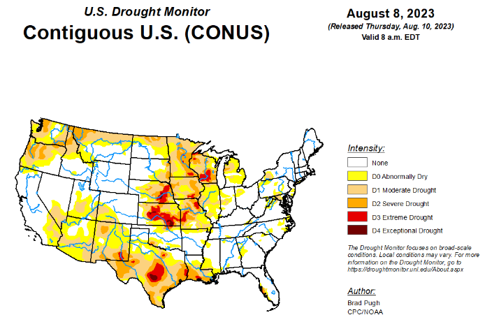
According to the latest U.S. drought monitor, A strong area of mid-level high pressure, anchored over the southern tier of the country, continued to promote above-normal temperatures and mostly dry weather across the Rio Grande Valley, Texas, and the lower Mississippi Valley. Weekly temperatures (August 2 to 8) averaged more than 6 degrees F above normal across portions of Louisiana, Texas, and southern New Mexico. The persistence of this pattern led to rapidly developing and intensifying drought across Texas and the lower Mississippi Valley. The Monsoon remains suppressed with increasing short-term drought across Arizona, New Mexico and southwest Colorado. Frequent rounds of heavy rainfall occurred from the central Great Plains southeastward to the middle Mississippi Valley. During the first week of August, parts of Missouri received 5 to 10 inches (locally more) of rainfall. The wet start to August resulted in improving drought across parts of the Corn Belt. Farther to the north, drought continues to intensify across Wisconsin. On August 7, a severe weather outbreak with heavy rainfall affected the East. Short-term drought expanded this past week across parts of the Hawaiian Islands.
In the Southern Plains, increasing 30 to 60-day precipitation deficits coupled with excessive heat and high evapotranspiration rates support a widespread 1-category degradation across Texas, Louisiana, and southwest Mississippi. 30 to 60-day SPI/SPEI, NDMC’s short-term blend, and soil moisture were leaned on for these degradations. During the past two months, temperatures have averaged 2 to 6 degrees F above normal across parts of Texas and Louisiana. Heavy rainfall (more than 2 inches) resulted in a 1-category improvement to northern and eastern Oklahoma along with parts of Tennessee.
In the High Plains, above-normal precipitation since the beginning of July and a lack of support from the long-term indicators led to a 1-category improvement to west-central Nebraska and bordering areas of Kansas. Recent beneficial precipitation also resulted in improving conditions across parts of the Dakotas and Wyoming. Short-term drought was expanded across northeast North Dakota which remained to the north of the storm track. The lack of Monsoon rainfall this summer resulted in the addition of short-term drought to southwestern Colorado.
In the West, the suppressed Monsoon and associated above-normal temperatures resulted in a 1-category degradation across Arizona and New Mexico. Recent rainfall supported a decrease in abnormal dryness (D0) in southeast Montana, while a 1-category degradation was made to parts of northern Montana based on worsening short-term indicators. Following 1-category degradations to parts of Oregon and Washington the previous week, no changes were made.
Looking ahead, according to the Weather Prediction Center (WPC), during the next five days (August 10 – 14, 2023), moderate to heavy precipitation (0.5 to 2 inches, locally more) is forecast for the Midwest, Ohio and Tennessee Valleys, and Northeast. Farther to the south, little to no precipitation and above-normal temperatures are forecast to persist across the lower Mississippi Valley and Texas. Scattered thunderstorms may result in local amounts in excess of 0.5 inches for the Four Corners region. A warming trend is expected for the Pacific Northwest and intermountain West during mid-August.
The Climate Prediction Center’s 6-10 day outlook (valid August 15 – 19, 2023) depicts large probabilities (more than 60 percent) for above-normal temperatures throughout much of the West, southern Great Plains, and Gulf Coast. Probabilities for above-normal temperatures decrease farther to the north with a slight lean towards below-normal temperatures across the northern Great Plains. Above-normal precipitation is slightly favored across the northern Rockies, northern Great Plains, upper Mississippi Valley, and New England, while below-normal precipitation is more likely across the southern Great Plains and lower Mississippi Valley
To view the 6-10 Day Precipitation Outlook Map, click here.
To view the 6-10 Day Temperature Outlook Map, click here.
To view the Monthly Drought Outlook Map, click here.


