

Statewide Discussion: A Red Flag Warning is in effect today 1:00 PM through 9:00 PM in western including the Panhandle counties. A stretch of above normal temperatures and growing separation from wetting rains (generally 21-50 days) in the Warned Area has resulted in a transition to available fuels. Hot, dry and windy conditions today coupled with potential for dry thunderstorm development along the 100th Meridian and Panhandle counties will support potential active fire behavior on established wildfires. Southeast Oklahoma has somewhat improved chances for wet thunderstorms through midday with better opportunity develops late this afternoon. Generally, rainfall amounts are expected to be less around 0.10” outside of a individual storm cell holding lightning ignition potential
in place and some concern for erratic fire behavior on current wildfires.
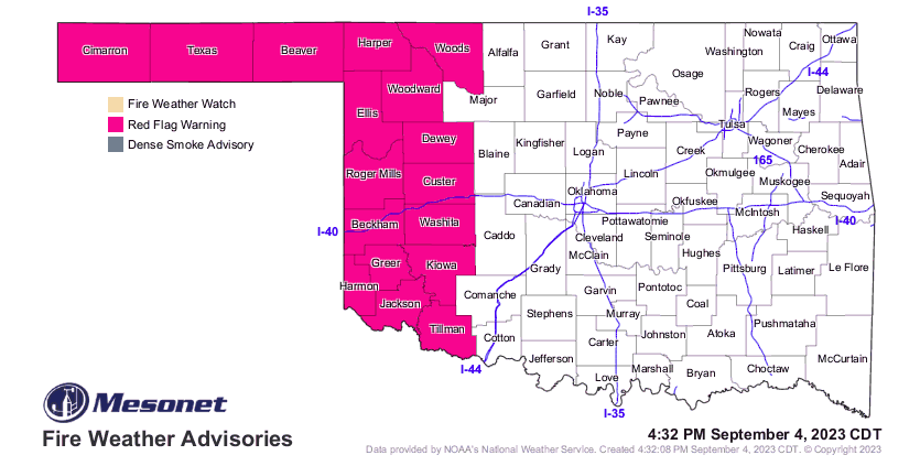
A Fuels & Fire Behavior Advisory has been issued covering the southern one-third of Oklahoma:
Today: A Red Flag Warning is in effect today across western Oklahoma and the Oklahoma Panhandle where near-critical
to critical fire weather will develop over increasingly available fuels. On established wildfires, problematic fire behavior is
expected coupled with resistance to control in high-risk fuels (grass/brush). In south-central/southwestern Oklahoma where the separation from wetting rain has pushed as high as fifty-four days, new fire activity will exhibit resistance to control. This area does have some potential for significant fire occurrence today. A number of going fires in southeastern Oklahoma will be subjected to the potential for outflow winds while lightning ignitions today cannot be ruled out.
• Warned Area (Western/Panhandle Counties): Temperature this afternoon 99°-106°under mostly clear skies with
relative humidity values 14-18% will yield receptive fine fuels this afternoon at 3% fine-dead fuel moisture. Live fuel
moisture in southwestern Oklahoma is very low and some areas have transitioned to dormancy offering enhanced fuel
availability. Additionally, there is potential for some thunderstorm development (predominantly dry) along the 100th
meridian, far northwest and Panhandle counties introducing lightning ignition potential this afternoon. Southwest winds
sustained 18-27 mph with some gusts exceeding 35 mph will support moderate to rapid rates if fire spread on established
wildfires. Rangeland fuels will support head fire rates of spread 125-177 ft/min (+/- 1.7 mph) on established wildfires. Fire
weather concerns remain in place until after sunset.
• Southeastern Oklahoma: Fire danger overall, will be relaxed to some extent today with rain/storm chances in place.
Showers in parts of southeastern Oklahoma this morning will remain focused in the area with wetting amounts possibly
scattered in the area. The primary fire weather concerns today will be: 1) Outflow wind effects on going fires, and 2) new
fire activity resulting from lightning strikes. Note, lightning ignitions today may holdover with delayed detection.
• South-Central Oklahoma: Lacking any meaningful rainfall in the previous 30 days, fuels (both herbaceous and woody)
have become available. Temperature this afternoon will top out at 99°-105°under partly cloudy skies. Afternoon relative
humidity values 23-35% will yield fine-dead fuel moisture values at 5% noting that herbaceous fuels in general are
available for combustion. Southerly winds sustained 13-20 mph with some higher gusts will drive head fire rates of spread on established wildfires at 80-115 ft/min in grass dominated fuels. Mixed fuels (grass/brush) will support potential for problematic to extreme fire behavior including single/group tree torching, short-range spotting and short crown runs.
Tuesday: Fire weather will again develop with emphasis on southwestern and northwestern Oklahoma. A cool front is forecasted to slip into the state tomorrow late afternoon offering some rain/storm chances from late afternoon into the evening along the I-44 corridor. Nonetheless, above normal temperatures and continued dry conditions through the day will result in persistent fire danger across western Oklahoma.
Burn Bans:


