Statewide Discussion: Hot temperatures will again dominate the forecast headlines today and tomorrow with 100°+ observations this afternoon across the west and south. A welcomed pattern change is in the offing beginning late Saturday with cooler temperatures and rain chances improving Sunday. Before this forecasted pattern change settles in, a few more days of elevated fire weather over stressed fuels will hold fire danger concerns in place.
A Fuels & Fire Behavior Advisory has been issued covering the southern one-third of Oklahoma:
Today: The highest fire danger indices today will be in across western Oklahoma and along the Red River where the strongest alignment of fire weather and fuels occurs this afternoon. This evening, low storm chances in western Oklahoma will present potential for dry lightning over receptive fuels. While slightly relative humidity and wind speeds below critical threshold will not meet warning criteria today, fuels will be receptive supporting active fire behavior. Initial attack efforts are expected to be successful noting that limited large fire potential exists largely due to fuels conditions. Thunderstorm chances do build in tonight over northeastern Oklahoma.
• Southwestern & Western Oklahoma: Temperatures will again push into the triple digit range this afternoon with highs
99° to possibly 107°. Relative humidity values this afternoon will dip as low as 11% in the western Panhandle with most
of western Oklahoma 19-27% yielding fine-dead fuel moisture at 3-4%. Lacking wetting rains for an extended period of
time, live fuel moisture values have dropped significantly bringing enhanced fuels availability and overall fuel
receptiveness. During peak burning conditions this afternoon, southerly winds will be sustained 12-17 mph with some
higher gusts supporting moderate rates of fire spread. Rangeland fuels will exhibit head fire rates of spread generally less
than 90 ft/min with flame lengths 8-10 ft. Higher rates of spread will occur where wind and topography are aligned. Incident responders should anticipate problematic fire behavior including high fireline intensity, torching and spotting. There are low chances of thunderstorms this evening which may encourage erratic winds and changing spread direction coupled with potential for new lightning ignitions.
• Central Oklahoma: Initial attack activity is expected to continue today with temperatures 96° (north) to 106° on the Red River under clear skies. Relative humidity values will register 25-33% yielding fine-dead fuel moisture 4% south to 5% north. Initial attack efforts are expected to be successful, although challenging, given wind speeds 6-13 mph. Grass
dominated fuels will exhibit head fire rates of spread generally less than 90 ft/min although fire established in mixed fuels
will exhibit problematic fire behavior.
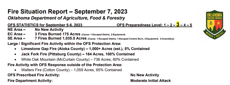
• Eastern Oklahoma: The highest fire danger indices remain across southeastern Oklahoma where ongoing fire activity
continues to exhibit frustrating resistance to control. Temperatures 93°-102°, mostly clear skies and afternoon relative
humidity values 29-32% will present very receptive fuels. Ongoing problematic and extreme fire behavior will continue
again today where fuels driven fire runs occur when aligned with topography. Light and somewhat variable winds will limit fire spread potential where slope is less than 10%. Rain/storm chances increase tonight in northeastern Oklahoma.
Near-Term: Rain chances increase Friday in areas of eastern Oklahoma while fire danger persists west with focus in the
southwestern counties. A pattern change is in the forecast to take hold Sunday and early next week.
Burn Bans: