

**This week’s rains in parts of Oklahoma should (hopefully) be reflected in next week’s drought monitor.
To view the Oklahoma Drought Map, click here.
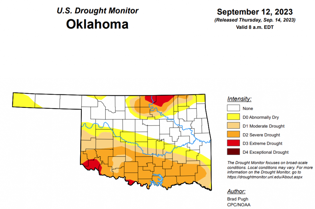
According to the latest Oklahoma Drought Monitor, exceptional drought remains at zero percent, unchanged for the past few weeks.
Extreme drought or worse is now at 3.51 percent, up from last week’s 2.72 percent.
Severe drought or worse is now at 29.8 percent, up from last week’s 24.96 percent.
Moderate drought or worse is now at 45 percent, up from last week’s 43.39 percent.
Abnormally dry or worse conditions are now at 62.07 percent, improved from last week’s 65.50 percent.
According to the 6-to-10-day precipitation outlook map, the majority of the state, aside from the far southeast corner, is leaning above a 40 to 50 percent chance of precipitation through September 23. The southeast corner is leaning above a 33 to 40 percent chance of precipitation through September 23.
To view the United States Drought Map, click here.
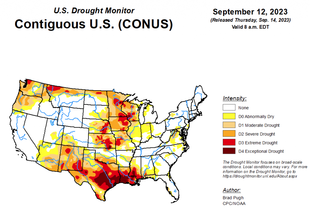
According to the latest U.S. drought monitor, widespread precipitation amounts of 0.5 to 2 inches (locally more) were observed across much of the Great Plains, Upper Mississippi Valley, and East. Improvements were made to areas that received the heaviest amounts. In the wake of a cold front, 7-day (September 5 to 11) temperatures averaged near to slightly below normal for the Northern Great Plains and Upper Midwest. Farther to the south, above-normal temperatures continued across the southern Great Plains and western Gulf Coast. Since early August, persistent excessive heat coupled with a lack of adequate rainfall led to a rapid onset and intensification of drought from Texas eastward to the Lower Mississippi Valley and parts of the Southeast. Monsoon rainfall began to decrease throughout the Four Corners region and Southwest during early September, while seasonal dryness prevailed along the West Coast.
In the Southern Plains, the rapid onset and intensification of drought continues throughout central and southern Mississippi. According to the NCEI, numerous counties in the southern half of Mississippi had their driest August on record and many of those counties have received less than 0.5 inch of precipitation during the first ten days of September. Along with this dryness, persistent above-normal temperatures have led to high evapotranspiration rates and worsening impacts to agriculture and high fire danger. Little change was made to Louisiana this week since the previous USDM map matches up well with the indicators (NDMC short-term blend and soil moisture) and many areas received at least a 0.5 inch of precipitation this past week. A 1-category degradation was warranted for southeastern Oklahoma and parts of Texas due to the prolonged excessive heat this summer and lack of adequate precipitation. The expansion of extreme (D3) to exceptional (D4) drought across central and eastern Texas was based largely on the 90-day SPEI and soil moisture indicators. Despite heavier rainfall (more than 1 inch) across west-central Texas, soil moisture indicators, 90-day SPEI, and NDMC’s drought blends support a continuation of D2+ levels of drought. More than 1.5 to 2 inches of precipitation prompted a 1-category improvement to northwestern Oklahoma and the northeastern Texas Panhandle.
In the High Plains, heavy rainfall (1.5 to 3 inches, locally more) prompted a 1-category improvement to southwestern Kansas along with parts of Nebraska. Also, NDMC’s drought blends were a factor in these improvements. Conversely, 30-day SPEI and soil moisture supported small degradations across eastern parts of Kansas. Worsening soil moisture indicators led to an expansion of severe drought (D2) across northeastern North Dakota.
In the West, much of the West was status quo this week as Monsoon rainfall begins to decrease during September and this is a drier time of year for California and the Pacific Northwest. However, low 28-day streamflows and SPEI at various time scales led to an expansion of severe drought (D2) across coastal Washington and northwestern Oregon.
Looking ahead, during the next five days (September 14 – 18, 2023), moderate to heavy precipitation (0.5 to 2 inches, locally more) is forecast for the southern Great Plains, western Gulf Coast, and Florida Peninsula. Hurricane Lee is forecast to track near New England and could bring heavy precipitation to coastal New England. Elsewhere, across the eastern and central U.S., mostly dry weather is forecast. Dry weather, typical for this time of year, is also forecast across California and the Pacific Northwest.
The Climate Prediction Center’s 6-10 day outlook (valid September 19-23, 2023) favors above-normal precipitation across the Great Plains and northern to central Rockies. Below-normal precipitation is most likely across the Northeast, Mid-Atlantic, eastern Corn Belt, and Tennessee Valley. Increased above (below)-normal temperature probabilities are forecast for the central (western) U.S., while 5-day temperatures are likely to average close to normal throughout the East.
To view the 6-10 Day Precipitation Outlook Map, click here.
To view the 6-10 Day Temperature Outlook Map, click here.
To view the Monthly Drought Outlook Map, click here.


