

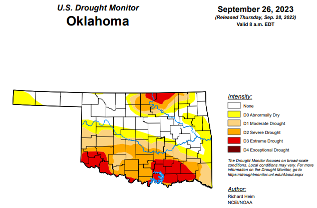
According to State Climatologist, Gary McManus, heavy rains across eastern Oklahoma yielded some good changes, but most of the southwestern half of the state was dealt a dry hand, and the same for north central Oklahoma. The area of extreme (D3) drought in southern Oklahoma continues to spread.
“Unfortunately, we’re not seeing big rains coming, but more of those convective type of storms that leave a lot of folks wanting,” McManus said. “We see increased odds of above normal precipitation, but ‘normal’ for this time of year is getting smaller and smaller.”
To view the latest Oklahoma drought map, CLICK HERE.
According to the latest Oklahoma drought monitor, exceptional drought remains at zero percent, unchanged from the past month.
Extreme drought or worse is unchanged from last week, remaining at 12.91 percent.
Severe drought or worse is now at 30.93 percent, improved from last week’s 34.6 percent.
Moderate drought or worse is now at 46.76 percent, improved from last week’s 48.72 percent.
Abnormally dry or worse conditions are now at 65.71 percent, improved from last week’s 71.55 percent.
According to the 6-10 Day Precipitation Outlook Map, the majority of the panhandle and southwestern Oklahoma is leaning above a 50 to 60 percent chance of precipitation through October 7. The rest of the state, aside from the southeast corner and the far west side of the panhandle, is leaning above a 40 to 50 percent chance of precipitation through October 7. As for that southeast corner of the state along with the western part of the panhandle, those areas are leaning above a 33 to 40 percent chance of precipitation through that date.
To view the United States Drought Map, click here.
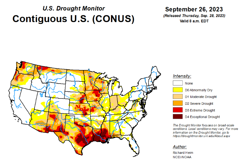
According to the latest U.S. drought monitor, the upper-level circulation over the contiguous U.S. (CONUS) during this U.S. Drought Monitor (USDM) week (September 20-26) consisted of an upper-level ridge of high pressure, that extended from the southern Plains to Hudson Bay, and a low-pressure trough over the eastern Pacific. The trough sent weather systems spinning across the CONUS, with their fronts and surface low pressure systems generating areas of rain across the Pacific Northwest, northern Rockies, and Great Plains to the Mississippi Valley. Meanwhile, Tropical Storm Ophelia moved up the East Coast, spreading rain from North Carolina to southern New England. These areas were wetter than normal for the week. Some of the rain was locally heavy, with over 5 inches reported in places. Much of the rain fell over severely dry areas, which resulted in contraction or reduction in the intensity of drought in parts of the Great Plains, Upper Mississippi Valley, and Mid-Atlantic states. It was drier than normal across the rest of the West, large parts of the central to southern Plains, and most of the country between the Mississippi Valley and Appalachians. The continued dry conditions from the Ohio Valley to central Gulf of Mexico Coast resulted in expansion or intensification of drought and abnormal dryness in these areas. Temperatures averaged warmer than normal beneath the ridge across the Plains, Mississippi Valley, and Great Lakes. The week was cooler than normal in the West and across the East Coast states.
In the Southern Plains, bands of heavy rain fell across eastern Oklahoma, western Arkansas, and the ArkLaTex, with amounts over 5 inches recorded. Amounts of half an inch to 2 inches extended outward from this central band. But the western half of Texas and Oklahoma, and much of Mississippi and Tennessee received little to no rain. Hydrological impacts were severe in parts of the South region, with Falcon International Reservoir in south Texas near record-low levels, comparable to the levels reached during the droughts of 2002 and 1956 (during the Great Plains 1950s Drought). Temperatures were warmer than normal across most of the region, with anomalies reaching 8 to 12 degrees above normal over Texas. Moderate to exceptional drought expanded in Mississippi, extreme drought expanded in southwest Oklahoma and southern Texas, and abnormal dryness and some moderate drought spread across parts of Tennessee. Abnormal dryness and moderate to exceptional drought were trimmed in parts of Oklahoma, Texas, and Louisiana, with 2-category changes occurring in places. Arkansas had contraction of drought in the west and expansion or intensification in the central to eastern parts. The lack of precipitation and persistently hot temperatures during the last several months in the South have severely dried out soils. According to September 24 U.S. Department of Agriculture (USDA) statistics, 80% of the topsoil moisture in Louisiana was short or very short (dry or very dry). The statistics were 75% for Mississippi, 66% for Texas, 63% for Oklahoma, 62% for Arkansas, and 38% for Tennessee.
In the High Plains, northern and eastern parts of the High Plains region received half an inch to over 2 inches of rain this week, while Colorado and parts of Wyoming and Kansas received little to no rain. D0-D4 contracted in Nebraska, D0-D3 were reduced in Kansas and North Dakota, and D0-D2 shrank in South Dakota. On the other hand, abnormal dryness returned to Wyoming and abnormal dryness and moderate drought expanded in Colorado. Two-thirds (67%) of the topsoil in Kansas was still short or very short of moisture, according to USDA statistics.
In the West, the southerly flow ahead of the eastern Pacific trough created an atmospheric river event that resulted in half an inch to 2 inches of precipitation across coastal areas from northern California to Washington. While the precipitation was helpful, it did not make up for deficits that have built up over the last several months; parts of Washington are still 10 inches or more below normal over the last 6 months. Severe drought was eliminated over southwest coastal Oregon where rainfall totals exceeded 3 inches and the total for the month was above normal. Much of Montana and parts of the northern Rockies received widespread 1 to 3 inches of precipitation; this resulted in contraction of D0-D2 in Montana. The rest of the West region received little to no precipitation. Abnormal dryness and severe drought expanded in Arizona, and extreme to exceptional drought expanded in southern New Mexico. USDA statistics indicated that three-fourths or more of the topsoil moisture was short or very short in Washington (82%), New Mexico (78%), Montana (77%), and Oregon (74%).
Looking ahead, in the two days since the Tuesday valid time of this USDM, the atmospheric river continued in the Pacific Northwest and rain has fallen across parts of the Midwest, Texas, and Florida. For September 28-October 3, a slow-moving weather system will drop 1 to locally 2 inches of rain across the Ohio Valley and parts of the Upper Mississippi Valley, while a Pacific weather system will move across the northwestern CONUS, spreading 1 to 2 inches of precipitation across the Pacific Northwest and Montana, with heavier amounts (up to 4 inches or more expected) in coastal areas of Washington and Oregon. The Florida peninsula is forecast to get 2 to 4 inches of rain, while the Gulf Coast, Rio Grande Valley, and Mid-Atlantic states can expect an inch or less. The Southwest, New England, Carolina Piedmont, and most of New York and the southern Plains to Iowa are predicted to receive little to no precipitation. Temperatures are progged to be above normal from the Plains to Northeast and near to below normal across the Southeast and West.
For much of the next 2 weeks, the atmospheric circulation will consist of an upper-level trough over the western CONUS and a ridge over the Mississippi Valley. The trough/ridge system will slowly shift east during the period. The Climate Prediction Center’s (CPC) 6-10 Day Outlook (valid October 3-7) and 8-14 Day Outlook (valid October 5-11) favor a fairly stable pattern of warmer-than-normal temperatures from the Plains to East Coast and cooler-than-normal temperatures over the West and over the southeastern half of Alaska. The outlook is for above-normal precipitation over the Plains, Upper Mississippi Valley, northern half of the West, and most of Alaska. Odds favor below-normal precipitation over the Northeast and Appalachian Mountain chain, extending into the Ohio Valley and to the central Gulf Coast, as well as in the Alaska panhandle.
To view the 6-10 Day Precipitation Outlook Map, click here.
To view the 6-10 Day Temperature Outlook Map, click here.
To view the Monthly Drought Outlook Map, click here.


