

To view the latest Oklahoma drought map, CLICK HERE.
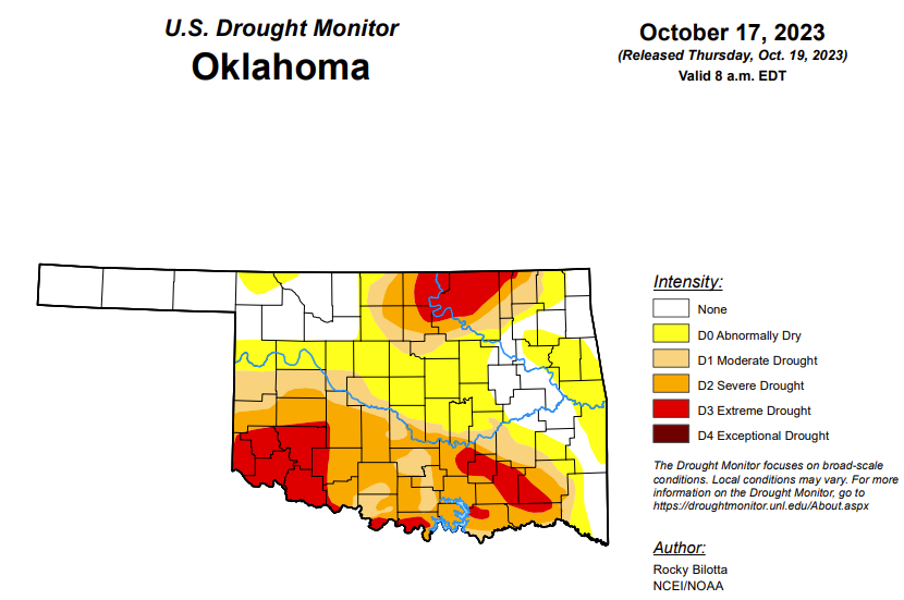
According to the latest Oklahoma drought monitor report, exceptional drought remains at zero percent, unchanged from 3 months ago.
Extreme drought or worse is now at 13.47 percent, up from last week’s 8.48 percent.
Severe drought or worse is now at 33.91 percent, up from last week’s 29.44 percent.
Moderate drought or worse is now at 48.24 percent, up from last week’s 43.11 percent.
Abnormally dry or worse conditions are now at 73.02 percent, up from last week’s 63.32.
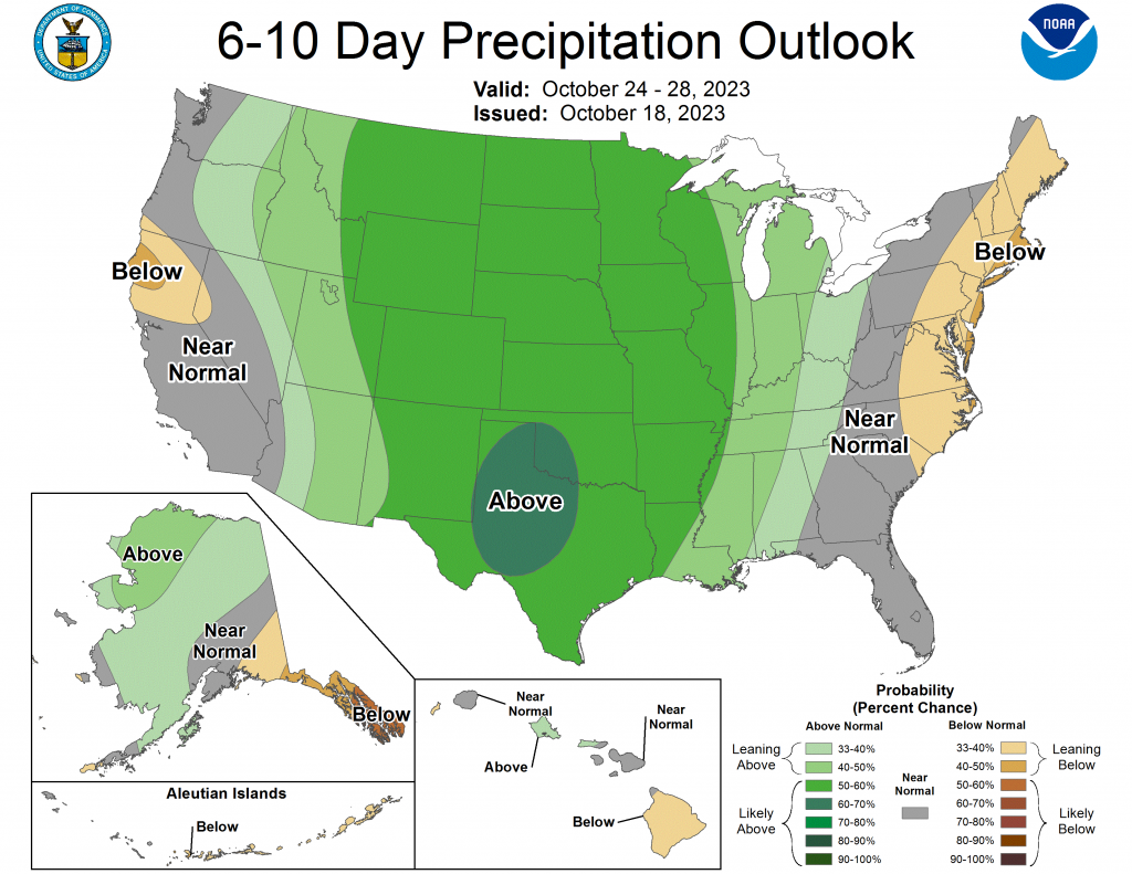
According to the 6 to 10-Day Precipitation Outlook Map, the majority of the state is likely above a 50 to 60 percent chance of precipitation through October 28. The southwest part of the state is likely above a 60 to 70 percent chance of precipitation through that October 28 date.
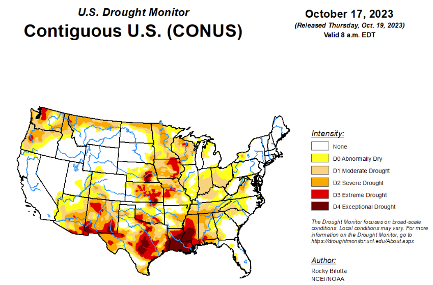
According to the latest U.S. drought monitor, an intense low-pressure system moved across the contiguous U.S., bringing heavy precipitation (greater than 2 inches) across much of the central Plains and Midwest this week. While in the southeast, upper-level energy moving across the Southeast brought rain over parts of Alabama, Georgia, South Carolina, and northern Florida, before moving into the southern Mid-Atlantic. The most widespread improvements were made to northern Nebraska, eastern South Dakota, southern Minnesota, southern Wisconsin, northern Indiana and southern Texas where more well above normal precipitation was observed this past week. Dry conditions continued across much of the Southern region, with widespread degradations occurring across the Tennessee Valley, central Mississippi Valley and northern parts of the southern Plains. Following a wet September, minor improvements were warranted for parts of Washington. In Hawaii, drought continues to intensify across parts of Kauai and the Big Island.
To view the United States Drought Map, click here.
In the South, dry conditions continue across much of the Southern region. Exceptional drought (D4) and extreme drought (D3) was expanded in central and northern Mississippi, while D3 was expanded into northern Louisiana. Moderate drought (D1) to severe drought (D2) was expanded in southern Arkansas. Board 1-category degradation occurred over the states of Oklahoma and Tennessee, in addition to parts of western, central and northern Texas, where dryness continues to degrade conditions. Precipitation in these areas are around 1-2 inches below normal for the month. The drought expansion and intensification was based on short-term SPI/SPEI, NDMC’s short-term blend, streamflow and soil moisture data. While heavy precipitation brought improvements to parts of southern and eastern Texas and in southern Mississippi, with some areas reporting over 2 inches of rainfall this week, resulting in exceptional drought being removed from southern Mississippi and extreme drought was removed from southern Texas.
In the High Plains, heavy precipitation brought widespread improvements to the southeastern parts of the region, especially along the South Dakota and Nebraska border. Much of northern Nebraska received at least 2 inches of precipitation, with some areas reporting more than 7 inches this week. Board 1-category improvements were made across northern Nebraska, while 2-category improvements were made where historic rainfall was reported. The heavy precipitation also improved abnormal dryness (D0) and moderate to severe drought (D1-D2) conditions in eastern South Dakota, as shown in short-term SPI/SPEI timescales and soil moisture data. A small area in southwest Nebraska, Chase County, was degraded to D1 due to acute dryness over the past two months and justified by short-term SPI/SPEI data and soil moisture being consistently under the 20th percentile. In Kansas, northern parts of the state received precipitation this past week but not enough to lead to large improvements. Precipitation did improve a small area of extreme drought (D3) in the central part of the state, in the counties of McPherson and Saline. Status quo was maintained across much of the state with some degradation occurring along the eastern part of the state based on SPI/SPEI and soil moisture data.
In the West, precipitation fell across much of the West with heavy precipitation along the coast from Washington to northern California, where more than 1 inch of precipitation occurred this past week. Above-normal precipitation led to improvements to severe drought (D2) in southwest Washington, along with abnormal dryness (D0) to extreme drought (D1-D3) improvements to western Oregon and D0 to moderate drought (D1) improvements in northern California. Beneficial precipitation led to improvements in moderate drought to extreme drought (D0-D3) in portions of northwest Montana, as shown in SPI/SPEI, streamflow and soil moisture data. Status quo was maintained across the rest of the region this week.
Looking ahead, during the next five days (October 19-24, 2023), a front extending from the Upper Mississippi Valley to the Southern High Plains will move eastward to the Lower Great Lakes/Mid-Atlantic to the Central Gulf Coast by Friday. The system will produce rain over parts of the Upper/Middle Mississippi Valley on Wednesday evening, moving into the Great Lakes/Ohio Valley by Thursday and continuing eastward into Friday. On October 21, guidance shows potential for significant rainfall over parts of the Northeast, while the West is forecasted to receive rain from the weekend into next week. Some of the precipitation over the West should fall as snow in the higher northern Rockies, with snow levels gradually declining with time.
The Climate Prediction Center’s 6-10 day outlook (valid October 23-27, 2023) favors near to above-normal precipitation throughout much of contiguous U.S., Alaska and Hawaii with below-normal precipitation most likely across the East Coast and in parts of southeast Alaska and on the Big Island in Hawaii. Increased probabilities for above-normal temperatures are forecast from the Plains to the East Coast, as well as much of Alaska and Hawaii, while below-normal temperatures are likely across much of the West.


