

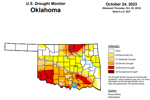
To view the latest Oklahoma drought map, CLICK HERE.
According to the latest Oklahoma drought monitor report, exceptional drought remains at zero percent, unchanged from the past three months.
Extreme drought or worse is at 13.47 percent, unchanged from last week.
Severe drought or worse is at 33.91 percent, unchanged from last week.
Moderate drought or worse is at 49.29 percent, up slightly from last week’s 48.24 percent.
Abnormally dry or worse conditions are at 72.12 percent, improved slightly from last week’s 73.02 percent.
According to the 6 to 10-Day Precipitation Outlook Map, the eastern half of the state is leaning below a 40 to 50 percent chance of precipitation through November 4. The western half of the state is leaning below a 33 to 40 percent chance of precipitation through that date.
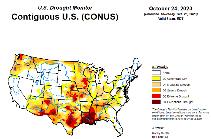
To view the United States Drought Map, click here.
According to the latest U.S. drought monitor, a strong upper-level ridge dominated much of the western U.S., providing anomalously warm temperatures, by as much as 20 degrees above average, and dry conditions over the central and western parts of the country. While a front extending from the Great Lakes to the Gulf Coast produced rain over parts of Ohio Valley and Great Lakes before moving eastward and bringing rain to parts of the Northeast and Southeast. The most widespread improvements were made to parts of eastern Texas, central Wisconsin and in parts of the Ohio River Valley, where above-normal precipitation was observed this past week. Dry conditions continued across much of the Southern region, with widespread degradations occurring across the Tennessee Valley, central Mississippi Valley and northern parts of the Southeast. In the Southwest, near- to record-warm temperatures coupled with below-normal precipitation for the month, resulted in degradation in the southern parts of the region. In Hawaii, drought continues to intensify across all islands, while no changes occurred on Kauai.
In the Southern Plains, dry conditions continued across much of the Southern region this week while heavy precipitation fell over parts of eastern Texas to southern Oklahoma. Portions of the Texas Panhandle received up to 4 inches of rainfall (up to 600% above normal) this week, resulting in removal of exceptional drought (D4) while extreme drought (D3) and severe drought (D2) conditions were improved in this region. On the dry side, a broad 1-category degradation was made to Arkansas, Tennessee and in northern parts of Mississippi and Louisiana, where little to no precipitation fell. Extreme drought was expanded in southeast Louisiana, while D3 was expanded in northern Louisiana, northern Mississippi and introduced in parts of central Arkansas and southern Tennessee. Precipitation in these areas are around 2-3 inches below normal for the month. The drought expansion and intensification was based on short-term SPI/SPEI, NDMC’s short-term blend, streamflow and soil moisture data.
In the High Plains, precipitation fell over the northern and eastern parts of the region, with much of the rain falling outside of the drought areas. For this reason, much of the High Plains remained as status quo this week. Little to no precipitation fell over most of Nebraska, Kansas, Colorado and southern Wyoming. This coupled with above-normal temperatures (around 10-15°F above normal), along with deteriorating conditions shown in short-term SPI/SPEI, streamflow and soil moisture data, justified slight degradations across these states. Severe drought (D2) was expanded in northeast Kansas, while moderate drought (D1) was expanded in the southeast part of the state. D1 was also expanded in parts of southwest Wyoming, while abnormal dryness (D0) was expanded from southwest Nebraska into northeast Wyoming and D0 was introduced along the central border of Kansas and Wyoming.
In the West, Much of the West remained as status quo this week. Precipitation fell across much of the region, which was enough to prevent further degradation but not enough to warrant large improvements. Heavier precipitation fell across parts of Montana, with rain totals up to 300-400% above normal, over the past week. This beneficial rainfall, along with precipitation percentiles and short-term SPI/SPEI, soil moisture and streamflow data, resulted in abnormal dryness (D0) and moderate (D1) to severe (D2) drought improvements along the northern parts of Montana. As for temperature, much of the region was well above normal with temperatures up to 15°F above normal. Parts of the Southwest are experiencing record warm temperatures for this month-to-date period, while Phoenix, AZ, reached 105°F on October 16th and 104°F on October 19th and 20th, setting the three hottest temperatures on record for this time of the year. These above-normal temperatures coupled with below-normal precipitation resulted in the expansion of D1 and D2 in southern Arizona and across the state of New Mexico. Introduction of D3 was also added to northwest New Mexico based on precipitation deficits and short-term SPI/SPEI and soil moisture data.
Looking ahead, During the next five days (October 24-28, 2023), remnant energy and moisture from Tropical Storm Norma could stream northward to spread heavy rainfall to parts of the southern and central U.S. early to mid-next week, while chances of snow increase in the northern Rockies and into parts of the northern Plains late next week. The Weather Prediction Center has highlighted a slight risk of excessive rainfall for parts of northern Texas and west-central Oklahoma due to potential flash flooding. Well above normal temperatures will spread from the Midwest into the East (15-20 degrees above normal), while daytime maximum temperatures for the northern portions of the Rockies and Plains could be 10-20 degrees below normal.
The Climate Prediction Center’s 6-10 day outlook (valid October 28-November 2, 2023) favors near to above-normal precipitation throughout much of contiguous U.S., and Alaska with below-normal precipitation most likely from the Pacific Northwest to the northern Plains, across much of Hawaii and in parts of southeast Alaska. Increased probabilities for below-normal temperatures are forecast for much of the contiguous U.S. while above-normal temperatures are likely from Louisiana to New England, as well as much of Alaska and Hawaii.
To view the 6-10 Day Precipitation Outlook Map, click here.
To view the 6-10 Day Temperature Outlook Map, click here.
To view the Monthly Drought Outlook Map, click here.


