

To view the latest Oklahoma drought map, CLICK HERE.
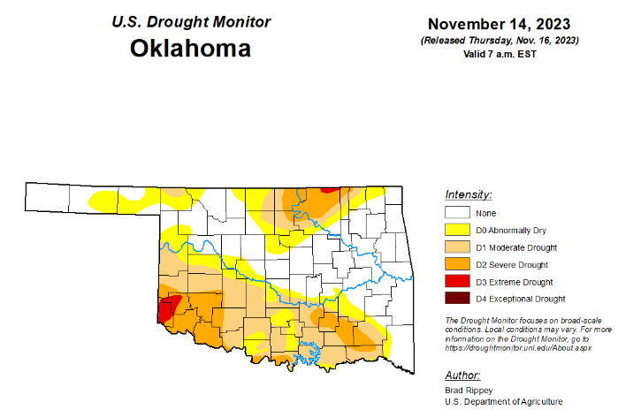
According to the latest Oklahoma drought monitor report, exceptional drought remains at zero percent, unchanged from the past three months.
Extreme drought or worse remains at 1.16 percent, unchanged from last week.
Severe drought or worse remains at 13.68 percent, unchanged from last week.
Moderate drought or worse has worsened just slightly at 36.34 percent, up from last week’s 35.81 percent.
Abnormally dry or worse conditions are now at 55.65 percent, up from last week’s 50.39 percent.
According to the 6-to-10-day precipitation outlook map, the entire state of Oklahoma is leaning below a 33 to 40 percent chance of precipitation through November 25.

To view the United States Drought Map, click here.
According to the latest U.S. Drought Monitor, during the drought-monitoring period ending November 14, precipitation was focused across a few geographic areas, including portions of the Northwest, South, and Great Lakes region. In places where precipitation fell, winter grains, cover crops, and rangeland and pastures generally benefited from the boost in topsoil moisture. That was especially true in the South, which has been contending with serious “flash drought” issues, including a rash of autumn wildfires. However, Southern rainfall coverage was spotty, with many areas receiving only light showers. Elsewhere, Northwestern precipitation was heaviest from the Cascades westward, although key agricultural areas farther inland received some moisture. Following a nearly nationwide cold outbreak in late October and early November, warmth returned across most of the country, amplifying drought impacts in some of the driest areas.
In the South, heavy rain in parts of Texas and along the Gulf Coast contrasted with mostly dry weather farther north and inland. Accordingly, one- to locally two-category improvements in the drought depiction were noted in western, central, eastern, and southern Texas, while other areas experienced either no change or one-category drought deterioration. In fact, exceptional drought (D4) expanded further into the Tennessee Valley and environs. On November 12, the U.S. Department of Agriculture rated topsoil moisture 88% very short to short in Louisiana, along with 84% in Mississippi. On the same date, pastures were rated 71% very poor to poor in Mississippi, along with 57% in Louisiana and 56% in Tennessee.
In the High Plains, pockets of drought were mainly focused across eastern and southern sections of the region, with worsening conditions noted in parts of Kansas and neighboring states. According to the U.S. Department of Agriculture, topsoil moisture was rated more than one-half very short to short on November 12 in Kanas (69%), Nebraska (61%), and Colorado (60%). On the same date, 17% of the U.S. winter wheat crop was rated in very poor to poor condition, although state-level numbers were higher in Kansas (33% very poor to poor) and Nebraska (18%).
In the West, aside from modest improvements in the Northwestern drought situation, there were few changes in the depiction. Despite the recent Northwestern precipitation, some interior agricultural areas remained dry, with topsoil moisture rated (on November 12, by the U.S. Department of Agriculture) 55% very short to short in Washington, along with 41% in Oregon. In addition, more than one-quarter (29%) of Oregon’s winter wheat was rated in very poor to poor condition on that date. Farther south, New Mexico led the region on November 12 with topsoil moisture rated 75% very short to short, despite patchy precipitation during the drought-monitoring period.
Looking ahead, mostly dry weather will prevail during the next several days across the nation’s mid-section, including the Plains and upper Midwest. Farther south, showers will continue to shift eastward along and near the Gulf Coast, with the potential for late-week rain and gusty winds in parts of Florida. During the weekend, a low-pressure system accelerating northward near the Atlantic Seaboard could result in coastal wind and rain in New England. Elsewhere, a storm system parked west of California will remain offshore for the next couple of days, although rain and snow showers will spread inland at times. Late in the weekend, some of the Pacific storm energy interacting with a surge of cold air arriving from western Canada should lead to an increase in rain and snow shower activity across parts of the western and central U.S., although precipitation will initially be light. The NWS 6- to 10-day outlook for November 21 – 25 calls for the likelihood of below-normal temperatures east of the Rockies, while warmer-than-normal weather will prevail in the West. Meanwhile, below-normal precipitation in most areas west of the Mississippi River should contrast with wetter-than-normal weather in the East, as well as northern sections of the Rockies and High Plains.
To view the 6-10 Day Precipitation Outlook Map, click here.
To view the 6-10 Day Temperature Outlook Map, click here.
To view the Monthly Drought Outlook Map, click here.


