

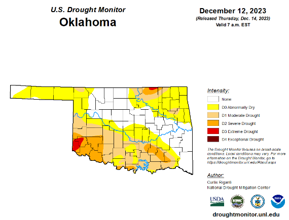
To view the latest Oklahoma drought map, CLICK HERE.
According to the latest Oklahoma drought monitor report, exceptional drought remains at zero, unchanged from the past three months.
Extreme drought or worse remains at 1.15 percent, unchanged from last week.
Severe drought or worse remains at 10.38 percent, unchanged from last week.
Moderate drought or worse is now at 32.88 percent, up slightly from last week’s 32.29 percent.
Abnormally dry or worse conditions are now at 67.68 percent, up from last week’s 57.68 percent.
According to the 6-to-10-day precipitation outlook map, the southeast part of the state is leaning below a 33 to 40 percent chance of precipitation through December 23. Further west into central Oklahoma, there is a near normal chance of precipitation, and the rest of the state, excluding the panhandle is leaning above a 33 to 40 percent chance of precipitation through that December 23rd date. The panhandle is leaning above a 40 to 50 percent chance of precipitation.
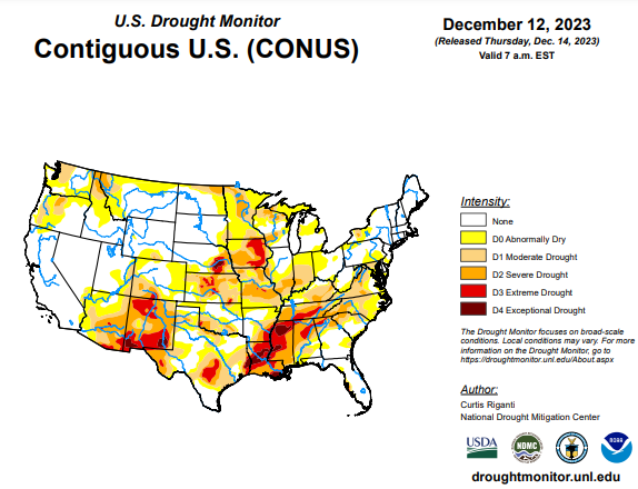
To view the United States Drought Map, click here.
According to the latest U.S. Drought Monitor, heavy precipitation fell this week across parts of the Pacific Northwest, associated with an atmospheric river. While precipitation amounts were hefty, improvements to drought were primarily confined to lower elevation areas, given the higher snow levels with this system. Aside from parts of the Rockies in Colorado and southeast Idaho and northwest Wyoming, mainly drier weather occurred from the southwest United States through the Great Plains and Upper Midwest. Widespread moderate to heavy rain fell with showers and thunderstorms from southeast Texas across much of the Southeast into the Mid-Atlantic and Northeast regions. Widespread improvements to drought conditions occurred with these heavier rains, though they were somewhat tempered by ongoing long-term precipitation deficits in some areas. Northwest of the heavy rains, drought and dryness expanded in some spots in Arkansas and in parts of the Upper Great Lakes and Midwest, as short-term precipitation shortfalls grew amid lowering streamflows and soil moisture. Rainfall from last week’s Kona low in Hawaii led to further improvements across parts of the state this week. For more local information, please see the regional summaries below.
In the Southern Plains, rainfall was widespread across parts of Louisiana and the southern half of Mississippi and far southeast Texas, and scattered parts of Arkansas saw heavier rain amounts. Otherwise, the rest of the region was quite dry, including most of Texas and Oklahoma. Short-term precipitation deficits worsened in parts of northeast Texas, northeast Oklahoma, and northern Arkansas, along with some reduction in soil moisture in some of these areas, leading to locally degrading conditions. In central Texas and parts of the Edwards Plateau, long-term precipitation deficits continued amid dwindling groundwater and paltry streamflow, leading to some expansions in severe and extreme drought. Conditions were reassessed in and around Midland and in the Dallas-Fort Worth Metroplex, where some minor improvements to ongoing severe drought and moderate drought were made. Farther east in the region, more significant changes occurred. The northwest-to-southeast gradient in precipitation amounts across Mississippi, Louisiana and southeast Texas led to primarily an increase of drought in southern Arkansas, northern Mississippi and east-central Texas, while conditions across other parts of Louisiana and Mississippi and southeast Texas saw improvements as short-term precipitation deficits lessened. Similar to areas farther east, long-term precipitation deficits and continued soil moisture and streamflow deficits limited these improvements.
In the High Plains, warmer-than-normal weather continued this week across the High Plains region. Temperatures ranged from mostly 4 to 12 degrees above normal, with locally higher readings. Weather across the lower elevation parts of the High Plains this week was mostly dry, which led to a few local degradations. In southeast Kansas, moderate drought expanded a bit, as streamflow and soil moisture dwindled and short-term precipitation shortages grew. Moderate drought expanded a small amount in western Kansas, where short-term precipitation shortfalls grew amid higher-than-normal atmospheric thirst. Larger changes occurred primarily in higher elevation parts of the region in Colorado and Wyoming. Conditions improved near Pueblo, Colorado and in adjacent parts of the plains, where recent snowfall alleviated short-term precipitation deficits. Low snowpack in the San Juan Mountains, on top of a drier-than-normal monsoon, led to the development of severe drought around Ouray and surrounding counties. Low snowpack in the Sangre de Cristo Range also led to the expansion of moderate drought outside of the San Luis Valley and into the high peaks east and north of Great Sand Dunes National Park. Severe drought also developed in and near parts of the Snowy Range of southern Wyoming, where the start of winter has featured much below normal snowpack. Southwest of there, recent snowfall has helped to alleviate precipitation deficits in parts of south-central Wyoming and northwest Colorado, leading to localized improvements. The northwest portion of the Wind River Mountains in Wyoming have seen much below normal snowpack to start the winter, and abnormal dryness has developed there.
In the West, a recent atmospheric river delivered widespread precipitation to the northwest United States, especially in high elevation areas, leading to local improvements to drought conditions. As this was a warmer atmospheric river, snowpack is still well below normal in some areas despite the atmospheric river, due to high snow elevation levels. Thus, improvements to drought conditions were somewhat tempered this week while the effects of this precipitation are being evaluated. Heavy rainfall doused parts of the central Oregon Pacific coast, leading to increases in streamflow and continued lessening of precipitation deficits; abnormal dryness was removed from this area. In eastern Washington, the Idaho Panhandle, and far northeast Oregon, conditions improved in lower elevation areas where streamflow increased and precipitation deficits lessened. In central Idaho, low snowpack, soil moisture and water year precipitation led to an expansion of abnormal dryness. Precipitation in central New Mexico last week lessened precipitation deficits and increased streamflow and soil moisture enough to improve severe drought to moderate drought. Temperatures in central California were mostly within a few degrees of normal. Otherwise, warmer-than-normal weather was common across the region, especially in Montana, where temperatures ranging from 8 to 16 degrees warmer than normal were typical.
To view the 6-10 Day Precipitation Outlook Map, click here.
To view the 6-10 Day Temperature Outlook Map, click here.
To view the Monthly Drought Outlook Map, click here.


