

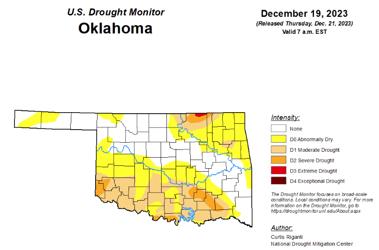
To view the latest Oklahoma drought map, CLICK HERE.
According to the latest Oklahoma drought monitor report, exceptional drought remains at zero, unchanged from the past three months.
Extreme drought or worse is now at .19 percent, down from last week’s 1.15 percent.
Severe drought or worse is now at 4.49 percent, down from last week’s 10.38 percent.
Moderate drought or worse is now at 26.15, down from last week’s 32.88 percent.
Abnormally dry or worse conditions are now at 61.81 percent, down from last week’s 67.68 percent.
According to the 6-to-10-day precipitation outlook map, the eastern half of the state and parts of western Oklahoma are leaning below a 33 to 40 percent chance of precipitation through December 30. Southwestern Oklahoma and the panhandle lean below a 40 to 50 percent chance of precipitation through that date.
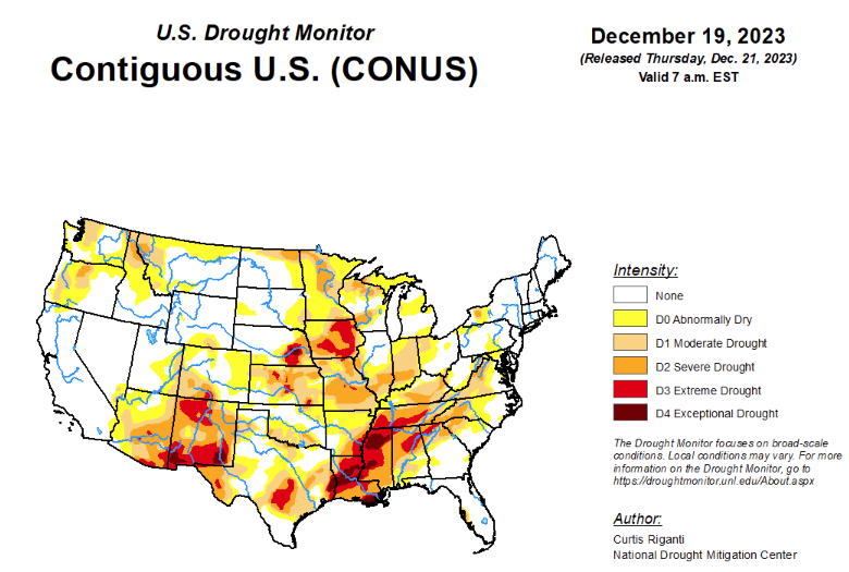
To view the United States Drought Map, click here.
According to the latest U.S. Drought Monitor, moderate or heavy precipitation amounts fell in three main areas this week: central and northern California, parts of the southwestern Great Plains (especially southwest Kansas through the Oklahoma and Texas Panhandles), and along the East Coast. Warmer-than-normal temperatures occurred this week across much of the central and northern contiguous United States. For areas in drought or abnormal dryness that received heavy precipitation amounts, improvements occurred locally due to lessening precipitation deficits and increased streamflow and/or soil moisture. In areas between the southern Great Plains heavy rain and the East Coast heavy rain, deficits in streamflow, soil moisture, and precipitation worsened, leading to widespread degrading conditions. Heavier rains fell on the northeast half of Puerto Rico this week, and scattered moderate drought and abnormal dryness continued on the island. A mix of degradations and improvements occurred in Hawaii this week, with a wet trade wind pattern bringing needed rainfall to windward slopes of Oahu and Molokai. Alaska remained free of drought and abnormal dryness this week.
In the Southern Plains, a soaking rain event occurred this week in parts of the western Great Plains, especially in the Texas and Oklahoma Panhandles and adjacent western Oklahoma and western north Texas. In these areas, precipitation deficits and soil moisture improved enough for widespread improvement to abnormal dryness or drought. Recent rains from before this week led to a reassessment of conditions and some localized improvements in eastern Tennessee. Drier weather occurred in between these locations, with the exception of some rain across Louisiana (which did little to improve the situation but prevented worsening of conditions). Deficits in soil moisture, streamflow, and short- and long-term precipitation continued to locally worsen in northeast Texas, Arkansas, northern Mississippi, and western Tennessee, leading to degrading conditions in some of these areas. Other than parts of Mississippi and Louisiana, most of the region experienced warmer-than-normal temperatures this week, with western Oklahoma and parts of western north Texas and the Texas Panhandle coming in at 4 to 8 degrees above normal.
In the High Plains, in parts of southern Colorado, south-central and eastern Nebraska, and much of Kansas, moderate to heavy precipitation amounts fell this week. Improvements to ongoing drought and abnormal dryness occurred in a north-to-south band across central and western Kansas, where this week’s precipitation lessened precipitation deficits and improved soil moisture. Localized improvements to drought also occurred in south-central Nebraska, where this week’s rain was enough to alleviate precipitation and soil moisture deficits somewhat. Low snowpack and dry conditions for the past few months continued in northern Colorado, leading to a southward expansion of moderate drought and abnormal dryness in high elevations.
The wet weather in southern Colorado led to some improvements to drought conditions. Dryness from the past couple of months increased in eastern South Dakota and in the Black Hills, leading to abnormal dryness expanding or developing in both areas. Temperatures in Nebraska, Colorado, and Kansas were mostly 3 to 9 degrees above normal, with a few local cooler exceptions. In the Dakotas, temperatures ranging from 6 to locally 15 degrees warmer than normal were common.
In the West, coastal central and northern California, and parts of the northern Central Valley and northern Sierra Nevada, received heavier precipitation this week, exceeding 2 inches in some places. Lighter precipitation amounts fell in coastal portions of Oregon and Washington. In parts of northern and southeast New Mexico, precipitation this week was enough to improve streamflow, soil moisture and precipitation deficits sufficiently for localized improvements to drought conditions. Short-term drying in parts of east-central Utah led to a small expansion of abnormal dryness. In southwest and south-central Montana, low snowpack amounts, short-term precipitation deficits, and soil moisture deficits led to localized expansion in drought and abnormal dryness. A reassessment of short- and long-term conditions in northwest Montana, the northern Idaho Panhandle, and parts of central and western Washington led to localized improvements to ongoing drought and abnormal dryness.
Looking ahead, from Wednesday, December 20 to Christmas evening, the National Weather Service Weather Prediction Center is forecasting three areas of heavier precipitation accumulations. The first, where amounts are likely to be between 0.75 to 3 inches of precipitation, is forecast for far western Oregon and Washington. In the Southwest, 0.75 to 2 inches of precipitation is forecast from Arizona into southern California, with higher amounts possible near and northwest of Los Angeles. From the central Gulf Coast northward to the middle Missouri and Mississippi River Valleys, precipitation amounts are forecast to range from a half inch to 2 inches, with locally higher amounts possible from northeast Texas into western Arkansas, and along the Louisiana, Mississippi, and Alabama coasts.
From December 26-30, the NWS Climate Prediction Center forecast favors below-normal precipitation for most of the region from the Mississippi River and Great Lakes west to the Great Basin. Above-normal precipitation is favored along the West and East Coasts and in deep south Texas. Below-normal temperatures are favored in areas near the Louisiana and Texas coasts. Elsewhere, near- or warmer-than-normal temperatures are forecast for much of the rest of the contiguous United States. Except for southwest Alaska, above-normal precipitation is favored for much of the state. Colder-than-normal temperatures are more likely in the western third of Alaska, while the eastern third is more likely to see warmer-than-normal weather. Drier-than-normal weather is favored across Hawaii, and cooler-than-normal temperatures are favored on the Big Island and the eastern half of Maui.
To view the 6-10 Day Precipitation Outlook Map, click here.
To view the 6-10 Day Temperature Outlook Map, click here.
To view the Monthly Drought Outlook Map, click here.


