

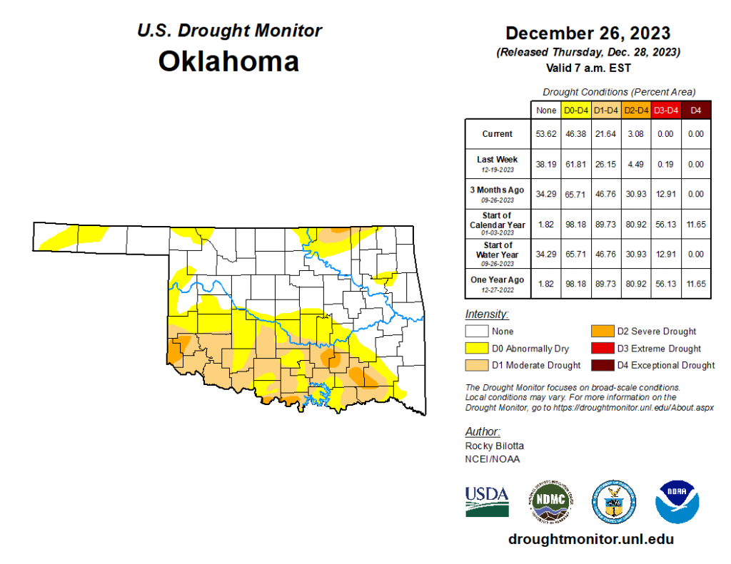
To view the latest Oklahoma drought map, CLICK HERE.
As we wind up 2023- there is zero amount of extreme or exceptional drought to be found in Oklahoma.
Severe drought now stands at 3.08 percent of the state versus 4.49% a week ago and at 80.92 percent at the end of 2022.
Moderate drought 21.64% this week- versus 26.15 % last week and 89.73% in the last report of 2022.
Abnormally dry conditions are now found in less than half of the state- at 46.38% versus 61.81% of the state last week and 98.18% of the state one year ago.
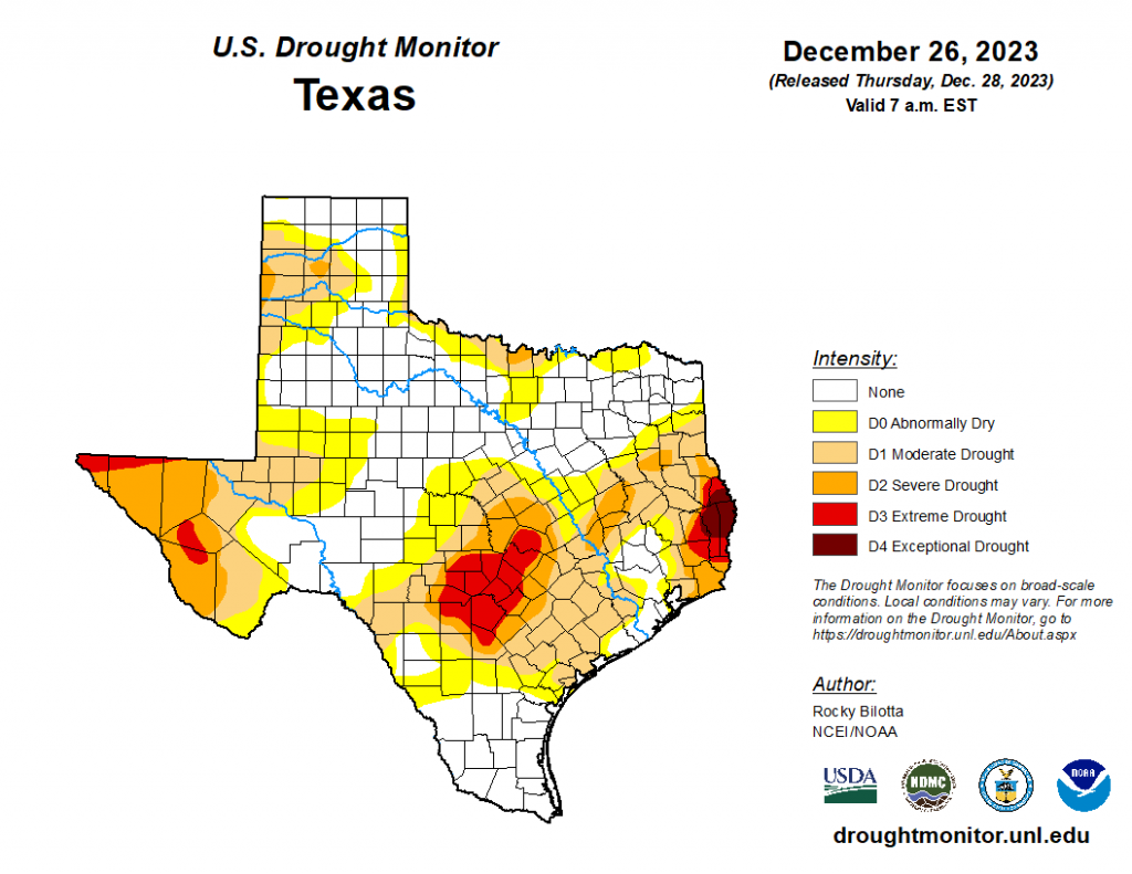
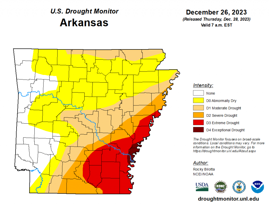
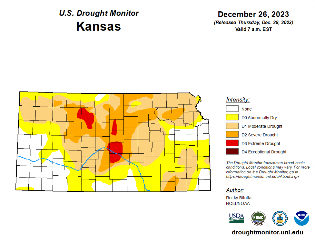
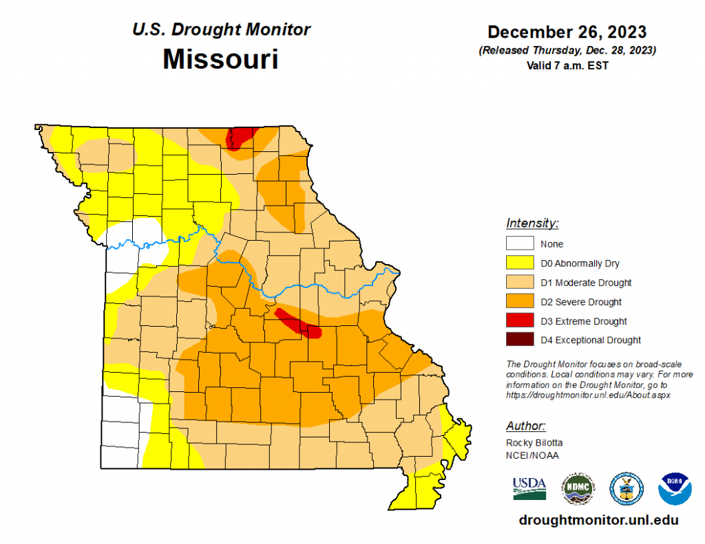
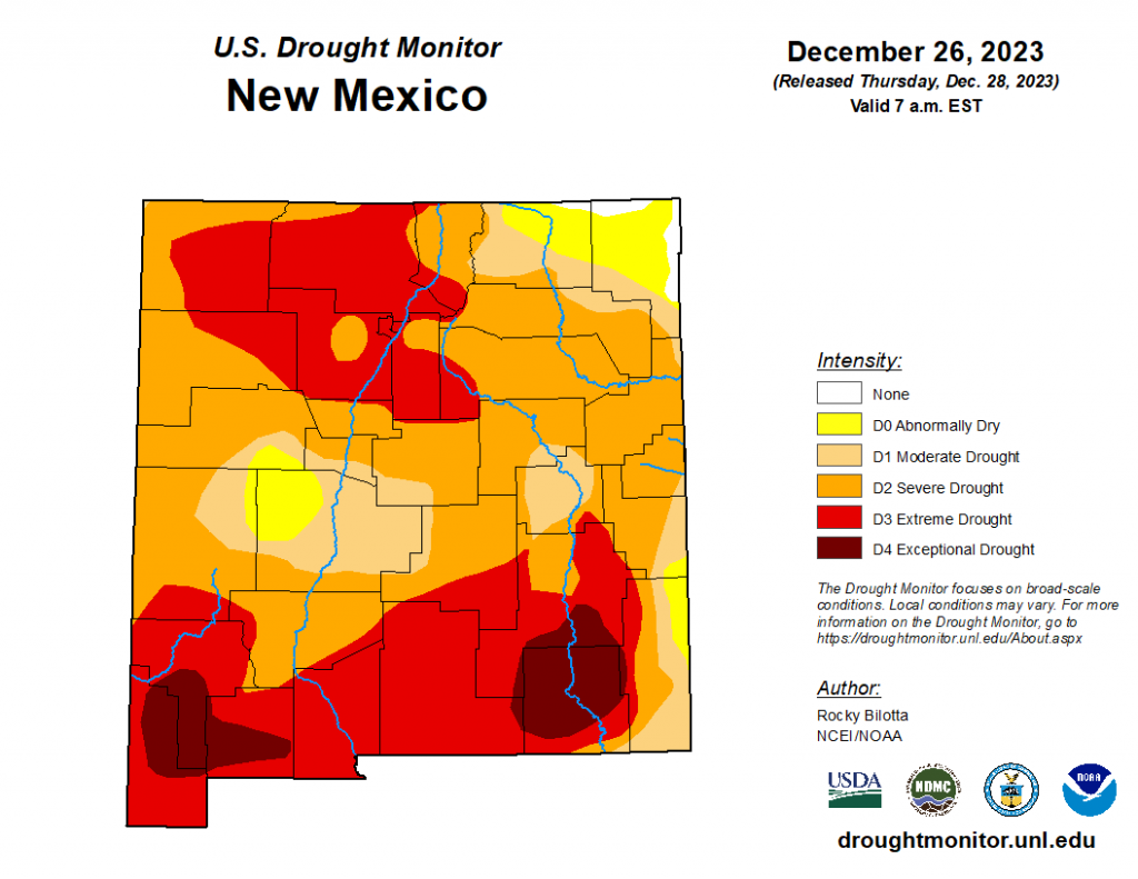
Click on the maps below for the Drought Monitor Numbers of surrounding states for this December 26th report.
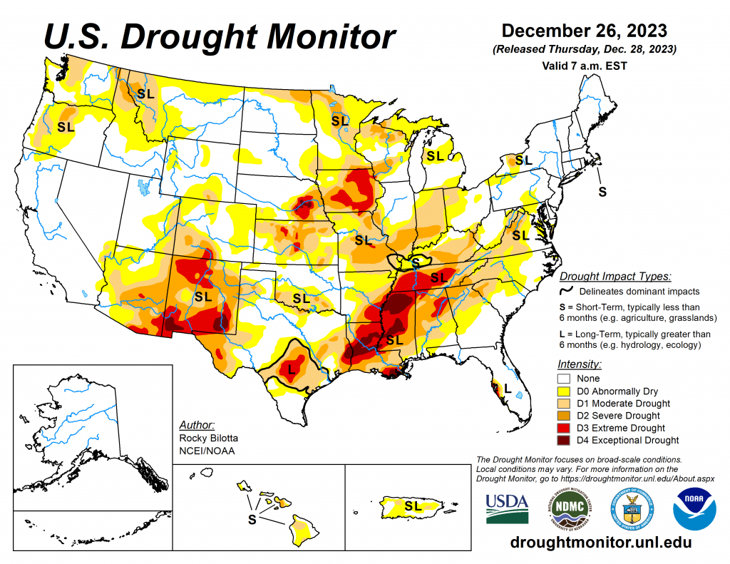
To view the latest US Drought Monitor Map with details- click here.
This Week’s Drought Summary
A low pressure system developed over the central Plains in conjunction with an amplifying upper-level trough dipping into the northern Plains brought active weather across much of the central to eastern U.S. Warm and moist air from the Gulf of Mexico moved northward ahead of the developing low pressure, producing widespread moderate to heavy rainfall from Texas to Louisiana. Meanwhile, a cold air mass from Canada dipped into the northern portions of the U.S. brought blizzard conditions to portions of the Central Plains and Upper Midwest. Temperatures were above-normal across most of the U.S., by as much as 20+ degrees F above average in parts of the Upper Midwest and Northern Plains. The most widespread improvements were made to parts of central Texas, eastern Nebraska, eastern Kansas, southern Louisiana and from northern Alabama to western North Carolina, where above-normal precipitation was observed this past week. Dry conditions continued across the eastern portions of the Southern region, with degradations occurring across much of Mississippi and into Arkansas and Tennessee. Drought and abnormal dryness were also expanded or intensified in portions of the northern Rockies and in parts southern Illinois, southern Texas and in the Southeast. In Hawaii, heavy rainfall improved conditions over parts of Kauai, Oahu and the Big Island, while no changes occurred on Molokai, Lanai or Maui.
Northeast
Light precipitation fell over ¬a large portion of the Northeast this week, while precipitation totals were below-normal across much of the region this week, month-to-date totals were 150% to 400% above normal. Much of the region remains free of drought, while the above-normal precipitation has helped alleviate abnormal dryness in portions of western New York, central Pennsylvania and along parts of the Maryland-Pennsylvania border where improvements were seen in short-term indicators, streamflow and soil moisture levels. For the week, average temperatures were above normal across much of the region with departures ranging from 1 to 9+ degrees F above normal, while pockets of cooler-than-normal temperatures were observed in portions of Delaware and small parts of Maryland and West Virginia. According to the National Weather Service (NWS) National Operational Hydrologic Remote Sensing Center (NOHRSC) regional snow analysis (12/26) reports that the Northeast Region is 9.3% covered by snow with an average snow depth of 0.2 inch and with a maximum depth of 14.4 inches.
Southeast
Precipitation fell across much of the Southeast this week with the heaviest amounts of rainfall being observed in areas from central Alabama to western North Carolina. These areas reported weekly precipitation amounts were up to 600% above normal and ranged between 2 to 8 inches of rainfall. Drought reduction and improvement were based on precipitation amounts, short-term SPI/SPEI, NDMC short-term blends, and improvements to streamflow and soil moisture data. Based on these short-term indicators, extreme drought (D3) was removed from northern Georgia and improved in northeast Alabama where precipitation amounts where up to 4 inches above normal for the month. Severe drought (D2) and moderate drought (D1) were reduced in parts of Alabama, Georgia, South Carolina and North Carolina, while a small portion of moderate drought in western Virginia was improved this week. Improvements in abnormal dryness (D0) occurred in parts of southern Alabama and along the coast of Georgia and South Carolina. On the dry side, abnormal dryness and moderate to severe drought categories were expanded across parts of Alabama and Georgia, where little precipitation fell. Based on precipitation deficits and short-term indicators, severe drought was expanded in the eastern part of Alabama where precipitation was up to 3 inches below normal for the month. Moderate drought was expanded in parts of central Alabama and central Georgia, while abnormal dryness was expanded into parts of southern Alabama and central Georgia.
South
Dry conditions continued across the eastern portions of the Southern region this week while heavy precipitation fell across much of Oklahoma and over parts of central and eastern Texas. Large portions of eastern Texas and Oklahoma received between 2 inches to 5 inches of rainfall (300% to 600% above normal) this week, resulting in improvement of exceptional drought (D4) in eastern Texas while extreme drought (D3) was removed from northeast Oklahoma and improved in parts of central and eastern Texas. Improvements were also made to moderate drought (D1) to severe drought (D2) conditions, along with abnormal dryness (D0), in this part of the region. Heavy rain was reported (2 to 4 inches of rainfall) over parts of southeastern Louisiana this week, resulting in the 1-category improvement across the area. Conversely, conditions continued to deteriorate in parts of Mississippi, Arkansas and Tennessee, where precipitation totals were 2 to 4 inches below normal this month. Exceptional drought was expanded in parts of central and northern Mississippi and was introduced into eastern Arkansas, while extreme drought was expanded into the northern portions of Tennessee and in parts of Mississippi and Arkansas this week. The expansion and intensification of drought categories were based on short-term SPI/SPEI, NDMC’s short-term blend, streamflow and soil moisture data.
Midwest
Average temperatures were well above normal across the Midwest, with temperatures ranging between 10 to 25 degrees F above normal this week. Much of the region also observed above-normal precipitation this week, especially along the western portions of the Midwest where the heaviest amounts totaled between 2 to 4 inches of rainfall and ranged between 1 to 3 inches (300% to 600%) above normal. Above-normal precipitation helped to alleviate longer-term precipitation deficits and improved soil moisture and streamflow impacts, resulting in improvements to abnormal dryness (D0) and all drought categories. A broad 1-category improvement was made across western Missouri, while additional improvements were made in parts of western Minnesota, northwest Iowa and western Illinois. Meanwhile, dry conditions continued to affect southern parts of Illinois this week, where precipitation is as low as 25% of normal for the month. Degradations were supported by precipitation deficits, short-term SPI/SPEI timescales, streamflow, soil moisture and groundwater data. The water table levels in Carbondale (Jackson County, IL) and near Rend Lake (Jefferson County, IL) are below normal, with both at or near record-low levels. Based on these short-term indicators, Moderate drought (D1) to severe drought (D2) was expanded in southern Illinois.
High Plains
Heavy precipitation fell over much of eastern portions of the region, where rainfall totals were greater than 600% of normal and ranged between 1 to 4 inches this week. Exceptional drought (D4) was improved in eastern Nebraska, while extreme drought (D3) was improved in eastern portions of Nebraska and Kansas where precipitation totals were up to 3 inches above normal for the week. Above-normal precipitation also led to improvements to severe drought (D2) and moderate drought (D1) over parts of eastern Kansas and northeast Nebraska. Abnormal dryness (D0) was improved along parts of the eastern border of the High Plains and in portions of western Kansas and eastern Colorado. Conversely, dry conditions persisted in portions of eastern Colorado and Wyoming where precipitation remains below normal this week. Deteriorating conditions shown in short-term SPI/SPEI, streamflow, soil moisture and snow water equivalent (SWE) data justified degradations across these states. Abnormal dryness was expanded in parts of northern Colorado and in eastern and southern Wyoming, while abnormal dryness was introduced in north-central and northeast Wyoming.
West
Much of the West remained as status quo this week. Precipitation fell across much of the region, which was enough to prevent further degradation but not enough to warrant large improvements. Heavier precipitation fell across the southern portions of Arizona and New Mexico, where rain totals were greater than 600% above normal this week. These beneficial rains, along with precipitation percentiles and short-term SPI/SPEI, soil moisture and streamflow data, resulted in abnormal dryness (D0) and moderate (D1) to extreme (D3) drought improvements along the southern border. Portions of La Paz and Yuma counties reported weekly rainfall totals up to 6 inches above normal. Conditions remained dry in northern parts of the Rockies, resulting in further deterioration across western Montana and eastern Idaho. Moderate drought and abnormal dryness were expanded in these areas based on short-term SPI/SPEI data, low snow water equivalent (SWE) percentiles and precipitation and soil moisture deficits. As for temperature this week, much of the region was above normal with well-above-normal temperatures were observed in parts of northeast Montana which were greater than 10 degrees F above normal.
Looking Ahead
During the next five days (December 26-30, 2023), An initial Plains/Midwest upper low will work to establish the eastern upper trough, and an associated surface system will spread rainfall of varying intensity over the East early-mid week along with the potential for lingering snow over the north-central Plains. Over the West, most precipitation should focus near the West Coast with a couple frontal systems tending to produce the highest totals over/near northern California. In terms of temperatures, expect unseasonably warm conditions in the East Tuesday and Wednesday ahead of the approaching frontal system. Morning lows should be particularly anomalous with readings 20-30 degrees above normal for much of the East and Upper Midwest. Warmer than normal temperatures will likely linger even longer in the Northeast through Thursday or Friday. Cooler air behind the system will initially still be on the mild side, with only slightly below normal readings over the central-southern Rockies/Plains on Tuesday. As upper troughing becomes established over the East later in the week, the Southeast and vicinity should trend cooler with temperatures dropping to 5-10 degrees or so below normal. Much of the West should see moderately above normal temperatures through the period.
The Climate Prediction Center’s 6-10 day outlook (valid December 31, 2023 – January 4, 2024) favors above-normal precipitation from California to Alabama, and across much of Alaska, with below-normal precipitation most likely from the northern Plains to the Northeast, in portions of the Northwest and Hawaii, and in parts of southern Florida and Alaska Panhandle. Increased probabilities for below-normal temperatures are forecast for much of southeastern U.S. and on the eastern islands of Hawaii, while above-normal temperatures over much of the West, along the northern tier and in parts of the southern Plains, as well as Alaska and western islands of Hawaii.


