

To view the latest Oklahoma drought map, CLICK HERE.
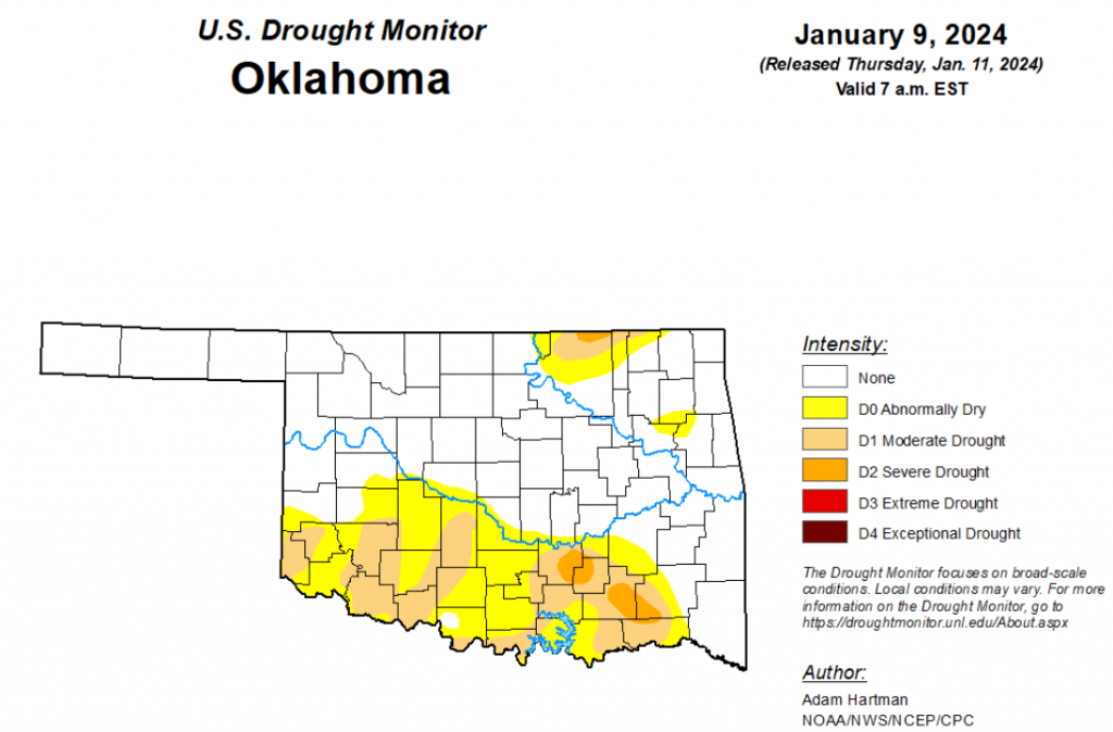
According to the latest Oklahoma drought monitor report, exceptional drought remains at zero percent, unchanged from the start of the calendar year.
Extreme drought or worse remains at zero percent, unchanged from the past two weeks.
Severe drought or worse is now at 1.67 percent, down from last week’s 3.08 percent.
Moderate drought or worse is now at 15.01 percent, down from last week’s 21.64 percent.
Abnormally dry or worse conditions are now at 34.19 percent, down from last week’s 44.68 percent.
According to the 6-to-10-day precipitation outlook map, the state’s northeast corner is leaning below a 40 to 50 percent chance of precipitation through January 20. The Panhandle is leaning below a 33 to 40 percent chance of precipitation through January 20, and the remaining parts of the state are leaning below a 40 to 50 percent chance of precipitation through that date.
To view the United States Drought Map, click here.
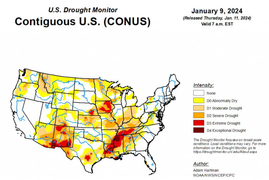
According to the latest U.S. drought monitor, it was a stormy week across much of the eastern lower 48 states, leading to widespread drought improvements east of the Rockies. A winter storm pummeled the Mid-Atlantic and Northeast over the weekend (January 6-7). Then a second system in its wake was ramping up across the Mississippi Valley toward the end of this week (Tuesday, January 9), bringing heavy rainfall to the Lower Mississippi and the Deep South. More than 2 inches of rain fell in many areas, with localized amounts upwards of 5 inches. Heavy snow also fell across parts of the Central Plains and Midwest as it moved slowly eastward, with snowfall still ongoing across parts of the Midwest and Great Lakes by the end of this week. Across the Intermountain West, it was a wet and snowy week mainly for parts of the Pacific Northwest and isolated locations in the Great Basin and Four Corners region, leading to some targeted improvements. However, several areas experiencing antecedent dryness and drought missed out on the precipitation, leading to further degradations, particularly across the northern Rockies, Front Range, and across parts of the western Colorado Plateau in Arizona. In Alaska, no changes to the drought depiction are warranted this week. In Hawaii, a Kona low spinning off to the north brought heavy bands of precipitation to western portions of the island chain, warranting some improvements to drought conditions. Conversely, another week of warm temperatures and below normal rainfall in Puerto Rico resulted in widespread deterioration of the drought depiction.
In the Southern Plains, much needed rain fell this week across much of the South, with many locations across the Lower Mississippi and Tennessee Valleys picking up well over 2 inches of rainfall. However, long-term drought conditions still very much remain in place across much of the Lower Mississippi Valley, with several areas across Louisiana and Mississippi experiencing upwards of 20-inch rainfall deficits over the past year. There are marked improvements in the upper layers of the soils and in some of the short-term drought indices in recent weeks, as the storm track has been active across the Gulf Coast states. However, more rainfall will be needed to dig into the long-term precipitation deficits and recharge groundwater. Improvements to drought conditions are also warranted across parts of the Southern Plains this week, where widespread precipitation totals in excess of 1 inch were received.
In the High Plains, storminess in recent weeks has resulted in widespread improvements across the Central Plains. Additional improvements were again warranted this week in the Central Plains, where a couple of storm systems brought wintry precipitation, with weekly snowfall totals of over 5 inches for many areas (locally more than 10 inches), further increasing short-term precipitation surpluses. Unfortunately, the storm track has predominantly been displaced southward across the southern half of the U.S. over the past couple of months, which has led to slow deterioration of drought conditions across portions of the western High Plains and along the Front Range of the Rockies. With another week of below normal precipitation, degradation was again warranted this week. Seasonal snowfall remains below average for many locations and daytime temperatures have been running above normal (and above freezing), exposing soils to evaporation, predominantly from high winds.
In the West, targeted improvements are warranted across parts of the Pacific Northwest and New Mexico, where 7-day precipitation totals, in combination with storminess in recent weeks, have improved some of the long-term drought indicators, even improving seasonal snowpack to be closer to normal for several locations. However, some degradation was also warranted in locations that missed out on heavier precipitation amounts this week, and who have experienced below normal precipitation and above normal temperatures over the past few months. Seasonal snowpack is running below normal throughout much of the Intermountain West, although interior portions of the Great Basin are faring a little better. So much of the recent improvements can be attributed to rainfall and improving soil moisture and stream flows.
Looking ahead, during the next five days (January 11-15), a storm system is forecast to develop and intensify east of the Rockies, bringing potentially heavy rain and snow to parts of the eastern U.S. In the wake of this storm system bitterly cold temperatures are forecast to spill southward from Canada, leading to dangerously cold temperatures and wind chills across portions of the central and northern U.S.
The Climate Prediction Center’s 6-10 day outlook (valid January 16-20), favors enhanced chances of below normal temperatures across much of the lower 48 states, with the highest chances (greater the 90%) centered over the Middle Mississippi Valley. Conversely, above normal temperatures are favored in the southwest U.S., underneath a mid-level ridge of high pressure that is forecast. Below normal precipitation is favored across many areas east of the Rockies during the next 6-10 days, as dry air moves in behind a departing storm system. However, a frontal boundary is forecast to remain draped across the Gulf of Mexico, bringing increased above normal precipitation chances to southern Texas and the Florida Peninsula. Above normal precipitation is also favored across parts of the West Coast, northern Rockies, and northern High Plains, associated with moist southwesterly flow into the northwestern U.S.


