

To view the latest Oklahoma drought map, CLICK HERE.
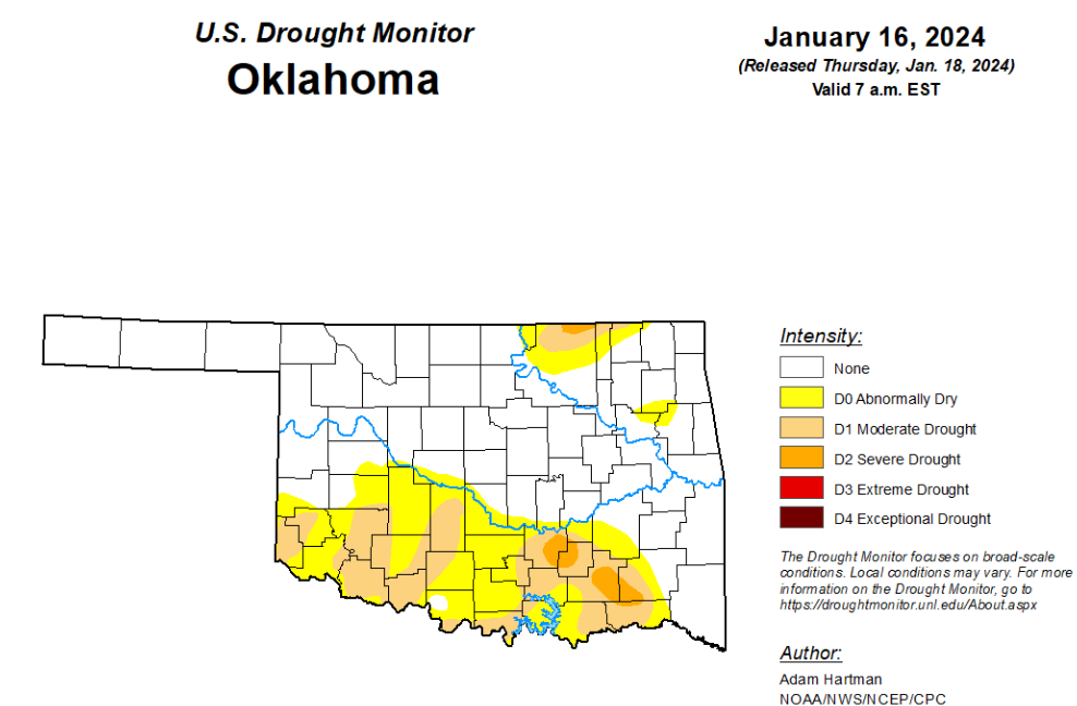
According to the latest Oklahoma drought monitor report, exceptional drought remains at zero percent, unchanged from the start of the calendar year.
Extreme drought or worse remains at zero percent, unchanged from the past three weeks.
Severe drought or worse remains at 1.67 percent, unchanged from last week.
Moderate drought or worse remains at 15.01 percent, unchanged from last week.
Abnormally dry or worse conditions remain at 34.19 percent, unchanged from last week.
According to the 6-to-10-day precipitation outlook map, the majority of the state is leaning above a 70 to 80 percent chance of precipitation through January 27th. In the northwest region of the state, there is a 60 to 70 percent chance of precipitation through that date. The western half of the panhandle is learning above a 40 to 50 percent chance of precipitation through January 27th.
To view the United States Drought Map, click here.
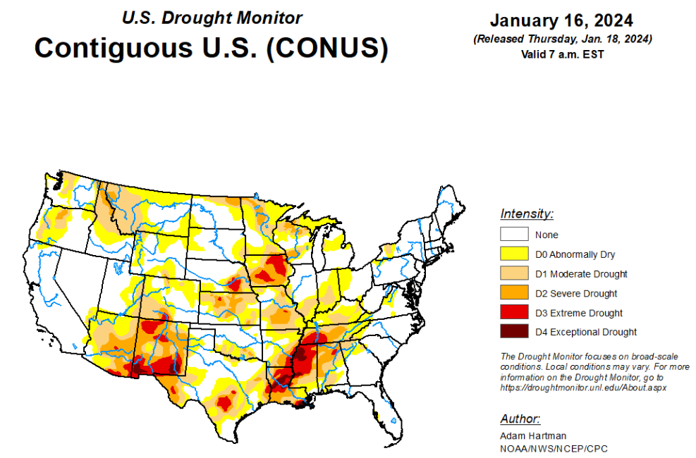
According to the latest U.S. drought monitor, it was another stormy week across much of the eastern lower 48 states leading to widespread drought improvements from the Mississippi River Valley eastward to the Appalachians. A powerful storm system early in the week (January 9-10) brought heavy rainfall to parts of the eastern U.S., with most locations from Georgia to New England picking up more than 2 inches of precipitation, leading to flooding for several locations. In some locations across the Mid-Atlantic and interior Northeast, flooding was exacerbated by melting snow left over from a winter storm hitting the region the previous weekend (January 6-7). Behind the powerful storm system early this week, cold air plunged southward from Canada across the northern tier states, gradually spreading southward and eastward and overtaking most of the country east of the Rockies by the end of the week (January 16). Toward the end of the week, another storm system dropped wintry precipitation in a swath stretching from the Ozarks eastward to the Mid-Atlantic and Northeast. Across the western lower 48 states, precipitation was above average for the week, leading to targeted improvements to drought areas across the Intermountain West, where snowpack continues to build for several locations. Unfortunately, weekly precipitation and seasonal snowpack remain below normal this week across the Southwest and northern Rockies, leading to some degradation of drought conditions. No changes are warranted in Alaska this week, as the snowpack is in good shape statewide. Hawaii received more heavy rainfall this week, predominantly from a Kona Low early on, leading to improvement. Conversely, another warm and dry week in Puerto Rico warranted another round of degradation.
In the Southern Plains, much of the precipitation this week fell across portions of the Ozarks and Tennessee Valley, associated with a couple of storm systems leading up to the start of the weekend (January 13), with many locations receiving in excess of 1 inch of rainfall. Toward the end of the week (January 15-16), a winter storm dropped several inches of snowfall across many of these same locations. Given the wetter than average conditions last week and another round of above average precipitation again this week, widespread improvement to drought conditions are warranted across portions of Arkansas and Tennessee. In parts of southern Texas, some degradation to the drought depiction is warranted, where short-term precipitation deficits are starting to mount. No changes are warranted elsewhere across the region due to above average precipitation last week and cold temperatures spreading across the region this week.
In the High Plains, storminess in recent weeks and frigid temperatures this week warrant no changes across much of the Central and Northern Plains. However, there are mixed improvements (Colorado Plateau) and degradations (High Plains along the Front Range) warranted this week. Improvements to snowpack and short-term precipitation deficits this week warrant the improvements across the Colorado Plateau. Conversely, the lack of seasonal snow cover has led to degradations across parts of the High Plains along the Front Range, due to topsoils being exposed and drying out.
In the West, some degradation of drought conditions is warranted where below average precipitation was observed this week. This is especially the case across western portions of Montana, where below average seasonal snow cover has left soils predominantly exposed, resulting in a slow decline in soil moisture over the past couple of months. On the other hand, targeted improvements are warranted across parts of the Pacific Northwest and eastern Great Basin, where 7-day precipitation totals and storminess in recent weeks have improved some of the long-term drought indicators. The active storm track in recent weeks has also led to gradual improvements to seasonal snowpack for several locations across the higher elevations of the Pacific Northwest, Great Basin, and portions of the Colorado Plateau.
Looking ahead, during the next five days (January 18-22), a fast moving storm system could bring some snowfall to portions of the Great Plains, Midwest, and Mid-Atlantic January 18-20. Surface high pressure behind this system is expected to gradually bring more southerly flow across much of the eastern U.S. as it moves eastward, leading to a moderation of the bitterly cold temperatures east of the Rockies, and some storminess across the south-central U.S., by January 22. A series of storms is also forecast to impact the West Coast over the next five days.
The Climate Prediction Center’s 6-10 day outlook (valid January 22-26), favors enhanced chances of above average temperatures across the entirety of the lower 48 states, with the highest chances (greater the 80%) centered over the Great Lakes. Enhanced chances of above average precipitation is also favored across much of the lower 48 states from coast to coast, with the highest chances (greater than 70%) across the south-central U.S. The exception is across the Northern Plains, where below average precipitation is favored.
To view the 6-10 Day Precipitation Outlook Map, click here.
To view the 6-10 Day Temperature Outlook Map, click here.
To view the Monthly Drought Outlook Map, click here.


