

To view the latest Oklahoma drought map, CLICK HERE.
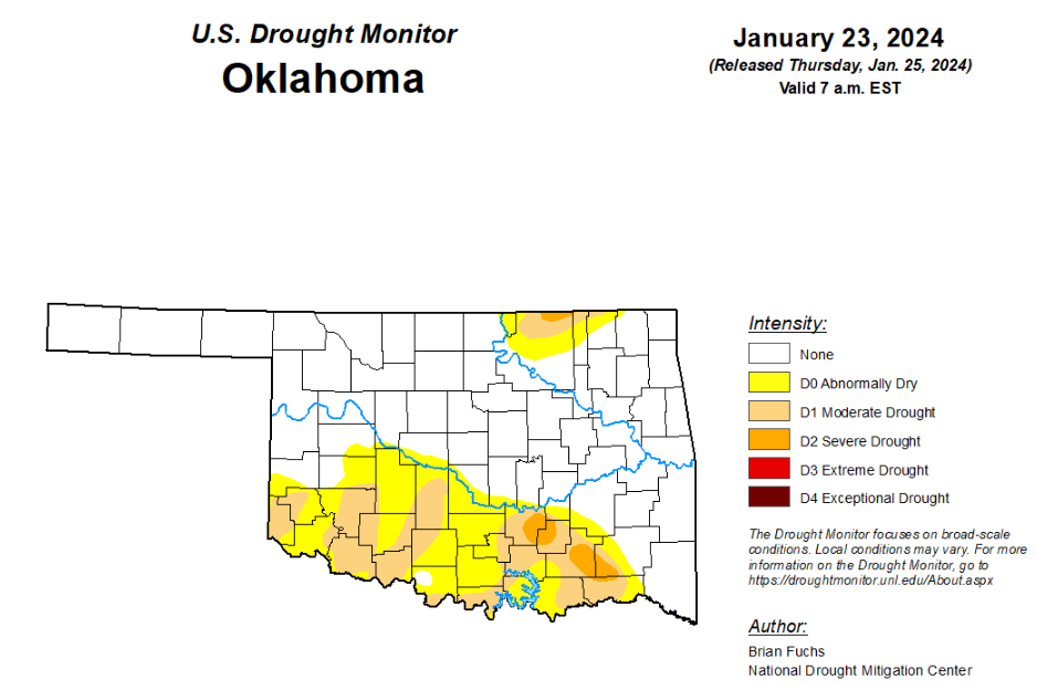
According to the latest Oklahoma drought monitor report, exceptional drought remains at zero percent, unchanged from the start of the calendar year.
Extreme drought or worse remains at zero percent, unchanged from the past four weeks.
Severe drought or worse remains at 1.67 percent, unchanged from the past two weeks.
Moderate drought or worse is now at 14.52 percent, down from last week’s 15.01 percent.
Abnormally dry conditions are now at 32.77 percent, down from last week’s 34.19 percent.
According to the 6-to-10-day precipitation outlook map, the majority of the state is leaning above a 40 to 50 percent chance of precipitation through February 3. A small portion of the northeast corner is leaning above a 33 to 40 percent chance of precipitation through that same date, and a small portion of the southwest border can expect a 50 to 60 percent chance of precipitation through February 3.
To view the United States Drought Map, click here.
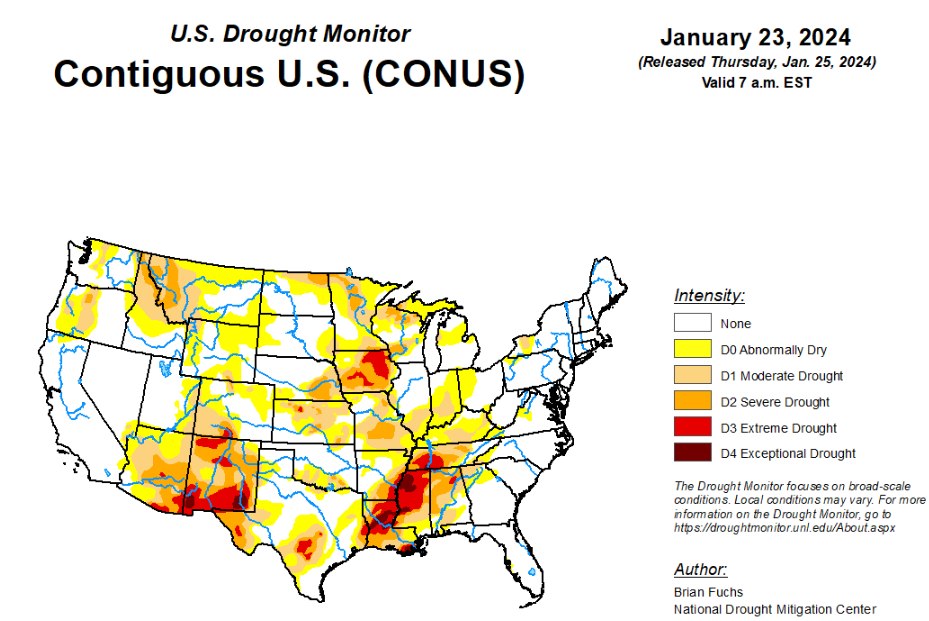
According to the latest U.S. Drought Monitor, the current period was dry over most of the country with the greatest amount of precipitation occurring along the west coast and from east Texas into Arkansas. Temperatures were well below normal for most locations east of the Rocky Mountains, where departures were 5 degrees or more below normal for most areas. The greatest departures from normal were over Tennessee, Kentucky, and northern portions of Alabama and Mississippi where readings were 20-25 degrees below normal. The warm winter continued in the West with temperatures 5-10 degrees above normal over a majority of the region. The warmer-than-normal temperatures have been a challenge for snow accumulation with many locations, especially in the northern Rockies, having a very challenging start to the snow accumulation season. With an active pattern through the central Plains into the Midwest the past few weeks, a reassessment of drought indicators was done in many locations this week to examine drought intensity levels and adjust where the data supported it. In most instances, drought remains but the data allowed for intensities to be reduced. The end of the period had an active pattern again developing in the southern Plains and into the South where widespread precipitation was anticipated after the data cutoff for this week. These locations will be assessed on next week’s map.
In the Southern Plains, cooler-than-normal conditions dominated the region with departures of 10-15 degrees below normal common in the region. The greatest rains took place in east Texas to southwest Arkansas and into southeast Oklahoma. These rains continued past the data cutoff period and everything from Tuesday morning forward will be assessed on the next map. The rains allowed for some improvements, with a full category change over much of east Texas and improvements to moderate drought over central and northern Arkansas as well as the far northwest corner of Louisiana and southeast Oklahoma.
In the High Plains, it was a mostly dry week over much of the region with only eastern Kansas receiving widespread, albeit light, precipitation. Temperatures were below normal for all areas outside the plains of Colorado and Wyoming and northern North Dakota where they were 3-6 degrees above normal. Outside of these areas, temperatures were generally 9-15 degrees below normal for the week. The wetter pattern over the last several months allowed for a reassessment of the data to investigate potential changes in the drought intensity levels. It was noted that even though the last 9-12 months have a stronger signal toward the wet spectrum, there are still long-term issues that go out 24-36 months or more in much of the central Plains. In looking at the data, support for the existing extreme drought in eastern Nebraska was not there, so it was improved to severe drought this week. In Kansas, areas of moderate and severe drought were also improved based on the lagging support for these intensity levels. Degradation took place over portions of northern North Dakota and eastern Wyoming where abnormally dry conditions were expanded based on the short-term dryness in these regions.
In the West, above-normal temperatures dominated much of the region with departures of 9-12 degrees above normal over portions of western Wyoming, northern Nevada, central Idaho and northeast Utah. Temperatures were cooler than normal over Washington, northern Oregon, northern Idaho and much of Montana. The greatest rains were along the coast with some flooding issues being reported this week, especially in southern California. Further inland, it remained dry and the dryness coupled with the warmer temperatures has allowed for snow drought to develop, especially in the northern Rocky Mountains. The wetter pattern over the most recent weeks allowed for a reassessment of conditions over New Mexico and into eastern Arizona, where improvements were made. Areas of extreme and exceptional drought were reduced this week in western New Mexico while severe drought was improved in western New Mexico into eastern Arizona. Moderate drought was expanded over western Wyoming and severe drought was expanded over western Montana. Oregon had moderate and severe drought improvements in the west while moderate drought expanded in the central portion of the state. Washington saw moderate drought improved along the northwest coast and western portions of the state with abnormally dry conditions expanding in the north central.
Looking ahead, over the next 5-7 days, the active pattern over the South and Southeast will continue, with much of the region anticipating 3-5 inches of precipitation. The coastal areas of the Pacific Northwest also will remain active with the next system coming ashore. Dry conditions are expected over the central and northern Plains, northern Rocky Mountains and Southwest. Temperatures will flip back to a warmer-than-normal pattern for most of the country, with greatest departures above normal over the northern Plains and upper Midwest.
The 6–10 day outlooks show a high probability of warmer-than-normal temperatures over much of the U.S. during this period with the highest probabilities over the Plains and Upper Midwest. There is a high probability of below-normal temperatures over Alaska and much of Florida. The precipitation outlook has the highest probability of below-normal precipitation over much of the eastern third of the U.S. with the greatest chances over the Ohio River valley. There are above-normal chances of above-normal precipitation over much of the West and into the Plains during this time.
To view the 6-10 Day Precipitation Outlook Map, click here.
To view the 6-10 Day Temperature Outlook Map, click here.
To view the Monthly Drought Outlook Map, click here.


