

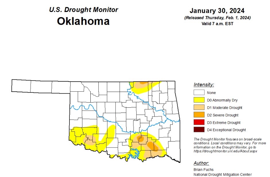
To view the latest Oklahoma drought map, CLICK HERE.
According to the latest Oklahoma drought monitor report, exceptional drought remains at zero percent, unchanged from the start of the calendar year.
Extreme drought or worse remains at zero percent, unchanged from the past five weeks.
Severe drought or worse is now at 1.36 percent, down from last week’s 1.67 percent.
Moderate drought or worse is now at 7.18 percent, down from last week’s 14.52 percent.
Abnormally dry or worse conditions are now at 22.45 percent, down from last week’s 32.77 percent.
According to the 6-to-10-day precipitation outlook map, the majority of the state, aside from the far southeast corner, is leaning above a 40 to 50 percent chance of precipitation through February 10. As for the southeast corner, that part of the state is leaning above a 33 to 40 percent chance of precipitation through that February 10 date.
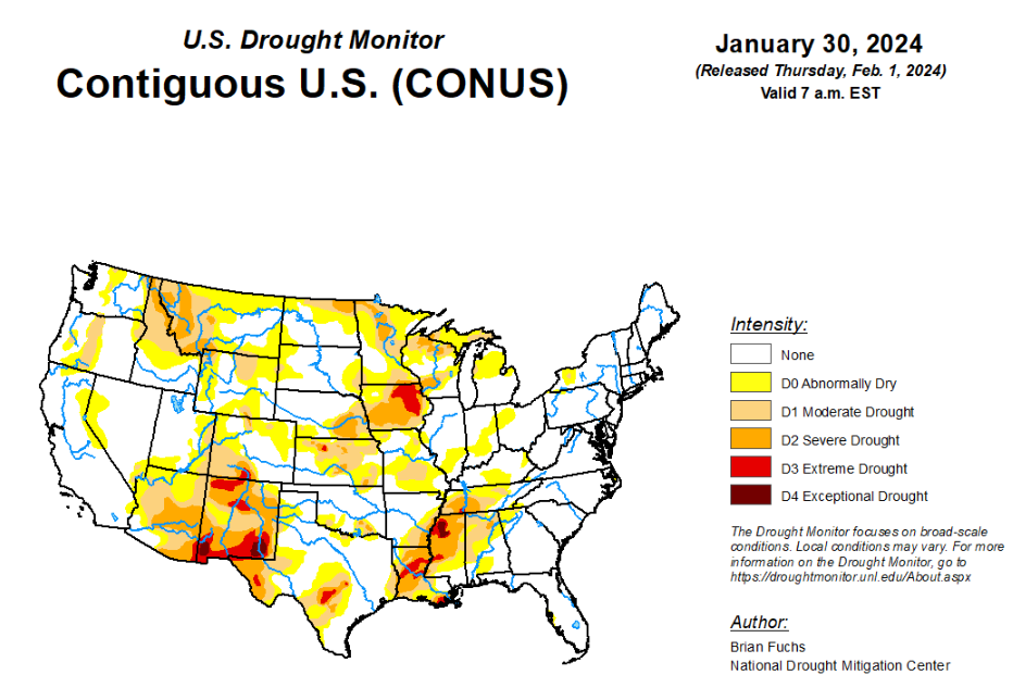
To view the United States Drought Map, click here.
According to the latest U.S. Drought Summary, the synoptic pattern over the last week favored continued precipitation over the coastal areas of the Pacific Northwest and very widespread and heavy precipitation in the South and Southeast and into the Midwest. Some areas of east Texas, Louisiana and Mississippi recorded over 8 inches of rain for the week. Dryness dominated the central to high Plains and most of the rest of the West as well as the Atlantic Coast into south Florida. After a very strong cold snap in previous weeks, temperatures this week were warmer than normal over much of the U.S., with the upper Midwest having the greatest departures of 15-20 degrees above normal in Minnesota and northern Wisconsin. Across the plains of Wyoming and Montana and into the northern Rocky Mountains, there is building concern over the lack of snow this current water year and snow drought concerns are also prevalent in portions of the High Plains and upper Midwest.
In the Southern Plains, temperatures were cooler than normal over central Oklahoma into northern Texas where departures were 1-3 degrees below normal. Most of the rest of the region was near normal to 3-6 degrees above normal, with the greatest departures over Mississippi where it was 9-12 degrees above normal. A very wet week for the region. Some areas of east Texas and into Arkansas recorded over 800% of normal precipitation for the week and almost all areas were 200-400% of normal precipitation. Widespread improvements to the overall drought status were made this week over most of Arkansas, Tennessee, Mississippi, Louisiana and east Texas where a full category improvement in drought intensity status was made. Some areas were investigated for multiple categories of improvement but with some of the long-term issues still showing up, most improvements were limited to a single reduction in intensity this week. Southern Oklahoma and north Texas had targeted improvements to the severe and moderate drought as well as the abnormally dry conditions. Portions of west Texas continued to be dry and may need to see drought intensification if the pattern doesn’t change.
In the High Plains, most of the region was dry this week, with only portions of central Colorado, far southwest Kansas, and northern North Dakota recording normal to above-normal precipitation. Temperatures were near normal over much of Kansas and central Nebraska and were 5-10 degrees above normal for most of the rest of the region. Most of the region did not see any changes to the drought status this week. Moderate drought was introduced over portions of western South Dakota and central Wyoming due to the ongoing dry winter and lack of snow. Abnormally dry conditions were improved in central Colorado based on the short-term improvements being observed there.
In the West, areas along the coast and inland and into the Southwest recorded above-normal precipitation this week while much of the central to northern Rocky Mountains were dry. The entire West was near to above normal for temperatures with the greatest departures over Montana, Wyoming, Utah and Idaho, where some areas were 10-15 degrees above normal for the week. This same area has been impacted by snow drought this current water year and there are developing concerns about water availability heading into the spring and summer as we approach February. Severe drought was introduced into more of southern and central Montana and into northwest Wyoming. Abnormally dry conditions were expanded in southern Utah and introduced into eastern California and western Nevada. Moderate drought expanded in northeast Oregon into Idaho and in southern Oregon in the Klamath Valley. Elsewhere in Oregon and Washington, improvements were made to moderate and severe drought in western Oregon and Washington while some areas of abnormally dry conditions were contracted. Areas of southern Arizona and southern New Mexico had improvements where extreme drought was removed from much of southern Arizona and reduced in southern New Mexico with additional improvements to moderate and severe drought.
Looking ahead, in the next 5-7 days, an active pattern is anticipated to remain over the South and Southeast with another week of widespread precipitation from east Texas to the Carolinas. Some precipitation is anticipated over the central Plains while a wetter pattern is anticipated over most of the West, with the greatest precipitation along the California coast. Temperatures during this period are anticipated to be below normal over California, Nevada, and into Utah and Arizona while warmer-than-normal temperatures are expected to impact the Plains, Midwest and portions of the South. The greatest departures of above-normal temperatures are anticipated in the upper Midwest and northern Plains with departures of 20-25 degrees above normal.
The 6–10 day outlooks show above-normal chances for warmer-than-normal temperatures over much of the country east of the Rocky Mountains with the greatest probability over the Great Lakes region and upper Midwest. The best chances for cooler-than-normal temperatures will be over the West and Florida with the best chances of below-normal temperatures over much of California. Much of the western half of the U.S. will have high probabilities of above-normal precipitation with the greatest chances over the Southwest. The best chances of below-normal precipitation will be in upper New England and through much of the Mid-Atlantic and into the Southeast. The highest probability of below-normal precipitation will be over Maine, New Hampshire and Massachusetts.
To view the 6-10 Day Precipitation Outlook Map, click here.
To view the 6-10 Day Temperature Outlook Map, click here.
To view the Monthly Drought Outlook Map, click here.


