Statewide Discussion: Verry-high fire danger will be present across Oklahoma today with extreme fire risk in far western
Oklahoma. A cold front this evening will cool tings off for Wednesday and provide some precipitation potential on Thursday, although another warming trend and concerning fire danger comes back in the spotlight this weekend.
Today: A Red Flag Warning is in effect today through this evening for a large portion of Oklahoma. The highest fire danger indices of the year will develop today ahead of a strong cold front. Firefighters will need to remain ware of the frontal timing in their area if working a fire due to the shift in fire spread direction and erratic fire behavior. Initial attack efforts have proven challenging with increasing occurrence of large fires (>300 acres) on the landscape. Today, significant fire (>5,000) acres) potential ramps up across northwestern Oklahoma while suppression difficulty also ramps up across the state.
• Northwest Oklahoma / Oklahoma Panhandle – Marginal overnight moisture recovery, a warm start and increasing
winds will support an early start to active burning conditions. Unlike yesterday, clear skies will enable solar radiation to
further heat fuels as temperatures top 70°-80° with relative humidity values 13-18% drive fine-dead fuel moisture to 3%.
West-southwest winds sustained 30-38 mph with some gusts topping 50 mph will drive extreme fire spread potential. The approaching cold front will progress through the Panhandle counties around 5:00 PM and move through northwestern Oklahoma by 7:00 PM with the associated clockwise shift in winds to the north placing emphasis on the south and east flanks of any going fire. Rangeland fuels will exhibit extreme rates of fire spread on established wildfires with head fire rates of spread 360-430 ft/min (+/- 4.2 mph) with flame lengths 18-22 ft. Frontal assault should be avoided!
• Along & North of I-44 – Persistent sky cover yesterday limited fine- fuels receptiveness to some extent, and more of the
same is expected today. Nonetheless, temperature will register 79°-84° with afternoon relative humidity values 17-23%
yielding very receptive fine fuels at 4% across most of the area. Southwest winds will increase to 23-30 mph with gusts
around 40 mph driving rapid rates of fire spread. Rangeland fuels will exhibit head fire rates of spread 270-340 ft/min (+/-
3.4 mph) with flam lengths 16-20 ft. Anticipate problematic fire behavior including torching and short-range spotting in
brush and juniper fuels. The frontal boundary and associated clockwise shift to northerly winds will arrive at the I-44
corridor around 9:00 PM. Monitor wind direction changes and anticipate erratic fire behavior as the cold front approaches placing specific emphasis on the south and east flanks of any going fire.
• South & East of I-44: Temperature will move into the 83°-87° range this afternoon with areas of clouds (especially south) and afternoon relative humidity values generally 20-24% yielding wild spread fine-dead fuel moisture observations of 4- 5%. Southwest winds will be strongest nearer to the I-44 corridor with southwest winds sustained 14-25 mph and gusts 25-35 mph. Grass-dominated fuels will exhibit head fire rates of spread 160-220 ft/min with flame lengths around 20 ft. Timber fuel types will exhibit ROS 22-35 ft/min with FL 4-6 ft. Mixed fuels will exhibit ROS 60-94 ft/min with FL 11-14 ft. The frontal boundary will push through the area after peak burning between 9:00 PM North to around 11:00 PM South.
Near-Term: Behind this cold front, temperatures will be much cooler on Wednesday (50°’s) with lighter winds, but dry conditions persist. Some precipitation chances are in the mix for Thursday although another warming trend will move us into the weekend with a notable dryline intrusion on Sunday supporting fire danger concern west and some severe potential east. OFS Resources Mobilized: Resource Hotline (800) 800-2481
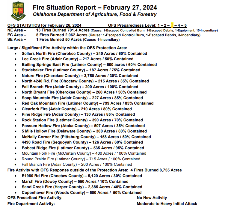
• Marsh Fire (Dewey County) – Suppression Group (TFLD/Engines/Dozers)
• Sand Creek Fire (Harper County) – Suppression Group (DIVS/Engines/Dozers)
o All resources will continue securing firelines today, working to become available for new fire dispatch this
afternoon.
Burn Bans: (None currently in effect) Refer to: bit.ly/OKBans for the most current burn ban information and links to specific burn ban proclamations.