Statewide Discussion: Impactful fire occurrence yesterday in northwestern Oklahoma with extreme conditions. Fire activity elsewhere in the state was also notable given the volume of wildfire activity in recent days requiring resource commitment. Oklahoma Forestry Services will continue to work alongside local fire department, county and emergency management organizations in the days to come while we also prepare for another round of escalating fire danger across western Oklahoma through the weekend ahead.
Today: Much cooler temperatures today in the post-frontal environment although fire danger remains a concern given very dry conditions and low relative humidity values. Winds will much less intense today offering opportunity to improve perimeter control of the going wildfire incidents.
• Northwest Oklahoma / Oklahoma Panhandle – Very cold conditions this morning in the post-frontal environment will
eventually warm into low-50°’s under mostly clear skies. Relative humidity values, however will again fall into the 14-23%
range given very low dew point temperatures supporting receptive fine-dead fuel moisture values at 5% across most of
the area. Stronger winds overnight, will begin diminish some as northerly winds begin to become variable in the afternoon transitioning to southerly flow overnight. Variable winds generally 10 mph or less with some higher gusts will support rates of fire spread much less challenging than yesterday. Rangeland fuels will exhibit head fire rates of spread generally around 90 ft/min with flame lengths averaging 9 ft.
• Along & North of I-44 – On the heels of a chilly start, temperatures will gradually warm into the 47°-52° under mostly
clear skies with afternoon relative humidity values 16-24%. Fine-dead fuel moisture values 5-6% yielding receptive
dormant fuels. Northerly winds will diminish some from this morning into the afternoon when north winds sustained 5-11 mph are expected. Rangeland fuels will support head fire rates of spread at a manageable 65-89 ft/min with flame lengths 7-9 ft. offering very good probability of successful initial attack efforts.
• South & East of I-44: Recent warm temperatures combined with adequate soil moisture has supported areas of early,
localized cool season green up offering some barriers to fire spread. Nonetheless, dormant vegetation dominates the
landscape. Temperatures will warm into the upper-40°’s to low-50°’s with afternoon relative humidity values 17-22%.
Under clearer skies north, 5% fine-dead fuel moisture observations will occur while 6% observations will occur further
south where afternoon cloud cover slides in. North winds will be strongest during the morning hours slacking of a bit into
the afternoon sustained 7-11 mph with some gusts above 15 mph. In grass-dominated, dormant fuels, head fire rates of
spread will top out around 90 ft/min with flame lengths maxing out at 12 ft. Timber-litter will exhibit ROS 10-20 ft/min and FL around 4.5 ft. Initial attack efforts are expected to be successful.
Near-Term: On the heels of an impactful wildfire, we are preparing for another round of significant fire weather over dry, heavily loaded fuelscapes. Yes, some precipitation potential creeps into the forecast for tomorrow (Thursday) although amounts are negligible and will have little, if any influence o the fuels moving into the weekend. Beginning today we will see another warming trend pushing temperatures again plu-20° above-normal coupled with fire-effective weather. Fire danger concern will begin to again ramp back up tomorrow spiking on Sunday with a dryline intrusion west and an approaching cold front. This translates into a strong potential for critical fire weather over heavily loaded, dormant vegetation west and some storm potential east.
OFS Resources Mobilized: Resource Hotline (800) 800-2481
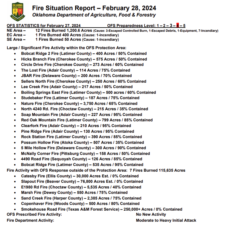
• Slapout Fire (Beaver County) – Suppression Group (TFLD/Engines/Dozers)
• Catesby Fire (Ellis County) – 2 Suppression Groups (DIVS/Engines/Dozers)
• OFS resources remain committed to a number of fires as reflected above in the fire activity report.
Burn Bans: (None currently in effect) Refer to: bit.ly/OKBans for the most current burn ban information and links to specific burn ban proclamations.