Statewide Discussion: Reduced fire danger today with some precipitation chances (very light totals expected) will offer
opportunity to improve containment on the over 30 large wildfires currently on the Oklahoma landscape. Initial attack activity is expected to be light today, although fire danger will quickly rebound into the weekend with another fire-effective weather pattern over dry, dormant fuels Saturday though Monday emphasizing another round of significant fire potential on Sunday focused in western/northwestern Oklahoma.
Today: Rain chances, generally cloudy skies and elevated relative humidity will facilitate reduced fire danger today. Reduced fire danger is a very welcomed pause this episode of significant fire occurrence, although it will be short-lived. Rainfall totals are not expected to total 0.10” for most location with realized observations more likely a few hundredths of an inch.
• Northwest Oklahoma / Oklahoma Panhandle – Temperatures hovering around or below freezing this morning will
gradually warm into the 44°-55° range with some low rain chances this afternoon over parts of northwestern Oklahoma
while the Panhandle counties are expected to remain dry. 1-hr. fuel moisture is not expected to dip below 7% today given
elevated relative humidity values and sky cover limiting potential for new fire starts. Any new fire activity will exhibit fire
manageable fire behavior with rates of spread in rangeland fuels generally less than 75 ft/min.
• Along & North of I-44 – Ample sky cover this afternoon, rain chances and elevated relative humidity values will serve to
pause potential for new fire starts today. Rain chances are highest in the southern portion of this area although amounts
will generally be negligible. Any fire activity occurring today should be easily suppressed.
• South & East of I-44: Rain chances increase into the afternoon and evening and while some locations may receive
around one-tenth of an inch, wetting rains are unlikely. New fire starts today, if there are any, should be easily suppressed.
Near-Term: Following an opportunity to improve containment on current wildfires and equipment rehab today, fire danger ramps up into the weekend. Dryline intrusion, above normal temperatures, an approaching cold front form a synoptic pattern supporting increasing concern for significant fire occurrence in northwestern/western Oklahoma. Sunday will present the most concerning alignment in the fire environment for significant fire development given any ignition.
Current 7-Day Quantitative Precipitation Forecast does not hold much hope for wetting rains over the majority of Oklahoma – especially northwestern and western Oklahoma where concern is greatest for additional significant fire occurrence in the coming days. While it is on the edge of predictability confidence, we are also eyeing potential for another fire-effective weather system later next week, OFS Resources Mobilized: Resource Hotline (800) 800-2481
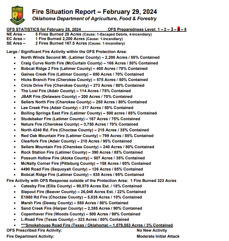
• Slapout Fire (Beaver County) – Suppression Group (TFLD/Engines/Dozers)
• Catesby Fire (Ellis County) – 2 Suppression Groups (DIVS/Engines/Dozers)
• OFS resources remain committed to a number of fires as reflected above in the fire activity report.
Burn Bans: (None currently in effect) Refer to: bit.ly/OKBans for the most current burn ban information and links to specific burn ban proclamations.