Statewide Discussion: OFS resources worked alongside local fire department and County Wildland Task Force resources
yesterday to continue securing control lines on the significant fires in western Oklahoma while OFS was able to declare controlled status on a number of the large fires that had plagued eastern Oklahoma in recent days. Precipitation over a large part of Oklahoma was welcomed although only scant amounts were realized on the western Oklahoma fires while most of the Panhandle received nil. Wetting amounts, or near wetting amounts, in areas of central and southeastern Oklahoma will serve to enhance some of the early green up. Fire danger concerns will be focused on western Oklahoma in the coming days as the dryline flexes deeper into the state each day through the weekend ahead of a weak
front on Monday and stronger front on Tuesday. A Fire Weather Watch is in effect beginning Saturday afternoon through Sunday evening with fire-effective weather over dormant vegetation in place. Despite the light precipitation in some
areas and good overnight moisture recovery, very strong drying conditions will accelerate drying conditions supporting another round of significant fire potential in the current Watch Area. We are currently anticipating a continual burning period Saturday through Sunday with little moisture recovery Saturday night.
Today: The highest fire danger indices today will develop in the Oklahoma Panhandle while dry air pushes in to far western Oklahoma setting the stage for tomorrow’s expansion of concern. Firefighters that continue to work the uncontained large fires from earlier this week were able to improve containment yesterday leveraging moisture and very good overnight moisture recovery, Though they are encouraged to continue to focus on those areas where heavy, heat-retaining fuels are present near current control lines – especially on the north and east flanks of fires.
• Oklahoma Panhandle / Extreme Western Oklahoma – Temperature will quickly warm today into the low- to mid-70°’s
under clear skies with afternoon relative humidity values as low as 11% in the western Panhandle to around 23% along
the 100th Meridian (OK/TX) border. Fine-dead fuel moisture values will tap 3% again in the Panhandle counties with 4%
observations along the OK/TX border. Variable winds this morning will become westerly in the Panhandle to southerly in
western Oklahoma sustained 7-12 mph with some higher gusts during peak heating. Rangeland fuels will exhibit
manageable head fire rates of spread 70-128 ft/min and flame lengths averaging 8 ft. Burning conditions will relax with
sunset supporting good initial attack success.
• Western Oklahoma – Precipitation amounts varied across the area yesterday registering nil to around 0.2” nearer to the I-35 corridor. Lingering clouds this morning will eventually clear out from west to east with temperature warming into 60°’s to near 70°. With higher dew points lingering, relative humidity values are likely to remain above 30% over most of the area stalling fine-dead fuel moisture values from tapping the concerning range. Southerly winds around 10 mph with
limited gusts will be combined with fine-dead fuel moisture values at 7% or higher across most of the area will support
very good initial attack success. Grass-dominated fuels will exhibit rates of spread less than 80 ft/min on most new starts.
• Eastern Half of Oklahoma: Temperature in the 60°’s with relative humidity values above 35% will limit fuel receptiveness and new fire activity today. Any new fires will exhibit significantly moderated fire behavior offering very good initial attack opportunities. South winds will be sustained 6-10 mph with some gusts to 15. Grass-dominated fuels will exhibit head fire rates of spread generally less than 80 ft/min.
Near-Term: A warming/drying trend into the weekend will present building fire danger concern across western and northern Oklahoma peaking Sunday/Monday. Th dryline will flex into western Oklahoma tomorrow and further east on Sunday ahead of a weak front on Monday followed by a stronger front Tuesday. Much of the area did receive scant amounts of precipitation although minimal effect on fuels will be realized. Above normal temperatures,
strong southwest winds and relative humidity values in the single-digits/teens will support increasing probability of large and/or significant fire occurrence. Complicating matters, poor overnight moisture recovery on Saturday night will
drive the likelihood of a 24-Hr. burning period. Incident responders are encouraged to continue patrolling recent fires seeking out potential trouble areas and continue the rehab and readiness preparations for personnel and equipment.
OFS Resources Mobilized: Resource Hotline (800) 800-2481
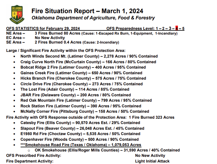
• Slapout Fire (Beaver County) – Suppression Group (TFLD/Engines/Dozers)
• Catesby Fire (Ellis County) – 2 Suppression Groups (DIVS/Engines/Dozers)
• OFS resources remain committed to a number of fires as reflected above in the fire activity report.
Burn Bans: (None currently in effect)
Refer to: bit.ly/OKBans for the most current burn ban information and links to specific burn ban proclamations.