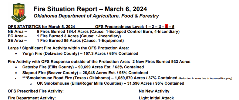
Statewide Discussion: Elevated afternoon relative humidity values today will offer very good opportunity for initial attack and the expectation that new wildfire occurrence will be stalled. With the reduction in fire danger and some early green up in areas, prescribed fire and controlled burning was noticeably more prevalent on the landscape yesterday and likely again today with some rain chances in the forecast. While rain chances look promising tomorrow, drier air will move into far western Oklahoma tomorrow afternoon driving potential for elevated fire weather over dry, heavily loaded rangeland fuels. Rain chances become more widespread in the overnight hours further west however the better chances of truly wetting amounts remain focused in central and eastern Oklahoma.
Today: The highest fire danger concerns today will reside in the western Oklahoma Panhandle while moderate fire danger indices develop across western Oklahoma. Higher dew point temperatures in central and eastern Oklahoma will hold afternoon relative humidity values well above critical value limiting fine fuels receptiveness. Overall, dry conditions continue through the day with some rain chances developing in eastern and some central counties.
• Oklahoma Panhandle – Good overnight moisture recovery will stall development of the burning period today although
drier air will push into the area by early afternoon. No critical fire weather indices will be met , although fuels remain dry
and receptive leading to the potential for stubborn initial attack activity today. Temperature will gradually warm into the
mid-60°’s under partly-cloudy skies with afternoon relative humidity values ranging from 17% in Cimarron County to 30% near the Beaver/Harper County line. Fine-dead fuel moisture will bottom out 5% offering receptive fuels although not to the concern in previous days. Variable winds this morning will become south-southwest remaining rather light for the area sustained 6-12 mph with some higher gusts in the western reaches of the area. Rangeland fuels will exhibit head fire rates of spread will average 90 ft/min with flame lengths around 8 ft. offering good initial attack opportunity.
• Central/Western Oklahoma – Higher dew point temperature across most of the area will limit relative humidity values
from dipping much below 40% except for areas along the 100th Meridian. With temperature in the mid- to upper-60°’s,
areas of lingering sky cover and afternoon relative humidity values 35-50%, fine-dead fuel moisture is not expected to
register below 7%. Probability of ignition will hold below 50% today. Rates of spread on a wildfire that does get initiated
will offer very good probability of initial attack success. Light south-southeast winds sustained 3-8 mph will present head
fire rates of spread less than 80 ft/min generally.
• Eastern Oklahoma– Rain chances build in later today and a moist atmosphere will stall wildfire occurrence potential. It
is anticipated that a number of prescribed fires and controlled burns will be conducted ahead of the forecast rainfall.
Temperatures will warm into the 70°’s at most locations although afternoon relative humidity values will stall around 45% holding fine-dead fuel moisture to 8%. Light and variable winds will limit spread potential affording excellent initial attack opportunity.
Near-Term: A dryline will attempt to push into the combined Panhandles and far western Oklahoma Thursday in advance of a cold front that has some promise of precipitation for he western counties. The depth of the dryline intrusion and timing of the cold front will be critical to the extent of fire danger concerns in the Oklahoma Panhandle and extreme western Oklahoma tomorrow. With that, we are anticipating some large fire potential on Thursday along and west of the dryline. Precipitation chances improve for most of the state through the end of the week and will determine the extend of fire danger concern when drier air returns early next week.
OFS Resources Mobilized: Resource Hotline (800) 800-2481
• Beaver County- Suppression Group (TFLD/Engines/Dozers) Available for Dispatch
• Catesby Fire (Ellis County) – Suppression Group (DIVS/Engines/Dozers) Available for Dispatch
• Woodward County – Suppression Group (DIVS/Engines/Dozers) Available for Dispatch
• 2 CL415’s – Burns Flat
• Interagency aviation resources including Air-Attack/SEAT’s/LAT’s in eastern Oklahoma and Texas.
Burn Bans: (None currently in effect) Refer to: bit.ly/OKBans for the most current burn ban information and links to specific burn ban proclamations.


