

To view the latest Oklahoma drought map, CLICK HERE.
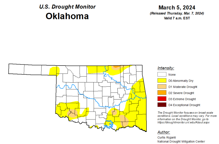
According to the latest Oklahoma drought monitor report, exceptional drought remains at zero percent, unchanged from the start of the calendar year.
Extreme drought or worse remains at zero percent, unchanged from the past ten weeks.
Severe drought or worse is unchanged from the past three weeks at .19 percent.
Moderate drought or worse is now at 3.85 percent, up from last week’s 3.23 percent.
Abnormally dry or worse conditions are now at 34.61 percent, up from last week’s 30.80 percent.
According to the 6-to-10-day precipitation outlook map, the panhandle and the far southeast corner of the state are likely above a 50 to 60 percent chance of precipitation through March 16. The remaining parts of the state are leaning above a 40 to 50 percent chance of precipitation through March 16th.
To view the United States Drought Map, click here.
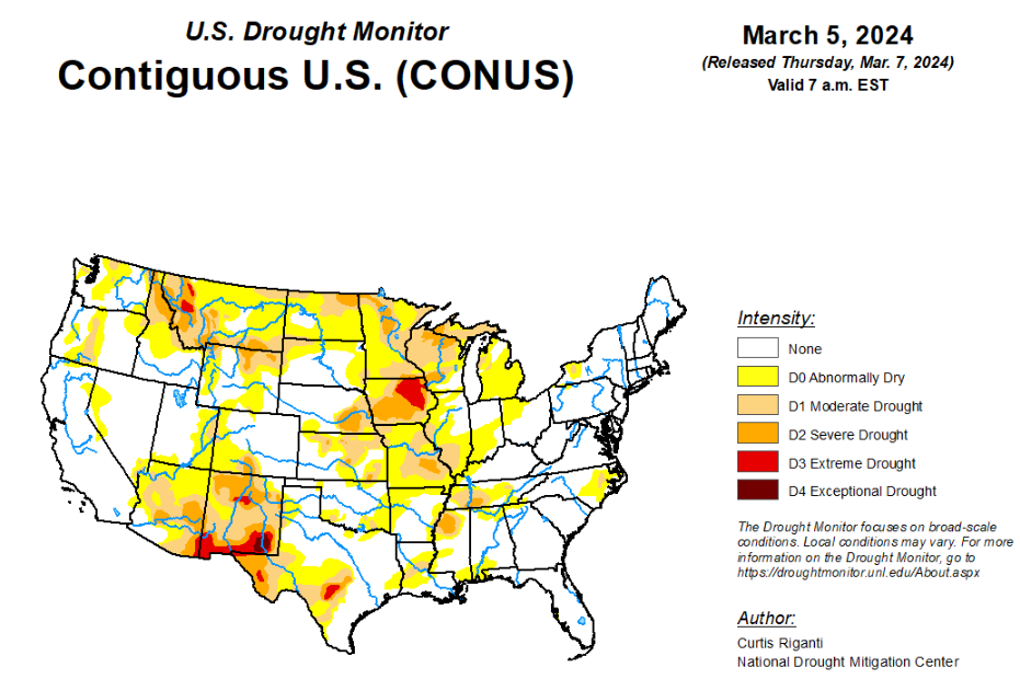
According to the latest U.S. Drought Monitor, heavy precipitation fell across parts of the southern and eastern U.S., and in parts of the West, especially in the Sierra Nevada, where a major blizzard significantly increased snowpack in that range. The Great Plains were mostly dry this week, as were parts of the Midwest, except for rain in parts of Illinois, southeast Wisconsin and Michigan. Recent rainfall improved conditions across much of Puerto Rico. Hawaii has been in a trade wind pattern recently, leading to wet weather on the windward sides of the islands but drier conditions on the leeward sides. Thus, a mix of improvements and degradations occurred there. Temperatures were near or below normal in much of the western U.S. west of the Continental Divide. In most of the central and eastern U.S., temperatures were near or above normal, especially in the Upper Midwest and Great Lakes, where temperatures from 10 to 15 degrees warmer than normal were common. A few spots in the Great Lakes area checked in even warmer than that, with readings 15-20 degrees above normal.
In the Southern Plains, moderate to heavy rain amounts fell across portions of Louisiana and Mississippi this week. Elsewhere, mostly dry weather occurred in the region, aside from isolated heavy rain from a thunderstorm in north-central Arkansas. Temperatures across the region were mostly either near normal or 5-10 degrees above normal, with a few spots in Texas coming in 5-10 degrees below normal. Recent rainfall continued to alleviate precipitation deficits in eastern Louisiana and in Mississippi, leading to some improvements in areas of moderate drought and abnormal dryness. In southwest Louisiana, short-term dryness and warmth and lowering streamflow levels led to a small expansion of moderate drought conditions. Abnormal dryness spread across parts of northern and western Arkansas, and a few isolated spots in Texas and Oklahoma, given short-term precipitation deficits, warm and windy weather, and low soil moisture.
In the High Plains, mostly dry weather occurred in the Great Plains portion of the High Plains region this week. Temperatures in the region ranged from mostly 5-10 degrees warmer than normal for far eastern Wyoming and Colorado and most of Kansas, Nebraska and South Dakota, to near or below normal temperatures in North Dakota, western Colorado and western Wyoming. Some of the mountainous parts of the region received significant snowfall, especially in west-central and northwest Wyoming and in the Medicine Bow Mountains in northern Colorado and south-central Wyoming. Improving snowpack levels led to reductions in coverage of moderate and severe drought and abnormal dryness in these areas, though improvements were more limited in southern Wyoming, where grass fires were reported west of Cheyenne recently and only light snow amounts were reported in the high plains west of Laramie. Given short-term dryness and high recent evaporative demand, abnormal dryness and moderate drought were expanded in northwest South Dakota, southwest North Dakota, and adjacent southeast Montana.
In the West, heavy precipitation fell this week across much of the central and northern Pacific Coast, and heavy snow also fell in a major storm in the Sierra Nevada. Significant snow amounts also fell across parts of Idaho and northwest and southwest Montana. Improving snowpack in these areas and lessening precipitation deficits led to improvements in drought or abnormal dryness in numerous locations. Recent precipitation in western and central Oregon continued to chip away at long-term precipitation deficits, leading to the removal of one long-term moderate drought area and coverage reductions of another. Meacher and Park counties in Montana have missed out on recent snowfall, leaving current snowpack numbers very low, and moderate drought worsened to severe drought. Heavy precipitation in northwest Washington (with some locations likely seeing over 9 inches of liquid precipitation) led to a reduction in moderate drought and abnormal dryness coverage. Along the Arizona-New Mexico border, severe drought coverage was locally reduced in a reassessment of short- and long-term drought conditions.
Looking ahead, through the evening of Monday, March 11, the National Weather Service Weather Prediction Center is forecasting widespread precipitation amounts of at least a half inch across much of the central and eastern U.S. (roughly from the Interstate 35 corridor eastward), excluding northern Wisconsin, Minnesota, the Michigan Upper Peninsula, the Florida Peninsula, and central and south Texas. Within this area of precipitation, swaths of at least 1.5 inches of liquid precipitation are forecast from southwest Missouri to southeast Michigan, from southwest Mississippi to central North Carolina, and across most of New England. In the West, mostly drier weather is expected, though some higher precipitation amounts can be expected in the western mountains of northern California, western Oregon and western Washington.
Looking ahead to March 12-16, the National Weather Service Climate Prediction Center forecast favors warmer-than-normal temperatures across the central and eastern U.S., with the highest confidence for warmer-than-normal weather centered around the Upper Midwest and Great Lakes. The forecast favors near- or below-normal temperatures in the Intermountain West, and above-normal temperatures along the West Coast. Above-normal precipitation is favored across large portions of the central and southern U.S., especially in Colorado and New Mexico and the adjacent western Great Plains and in the Deep South and along the Central Gulf Coast. The forecast favors below-normal precipitation along the West Coast. In Alaska, above-normal precipitation is favored in the central and eastern parts of the state, while drier-than-normal weather is favored in the northwest. Colder-than-normal weather is forecast in the central and western portion of Alaska, while southeast Alaska is likely to be warmer than normal. Cooler-than-normal weather is favored in Hawaii along with near-normal precipitation.
To view the 6-10 Day Precipitation Outlook Map, click here.
To view the 6-10 Day Temperature Outlook Map, click here.
To view the Monthly Drought Outlook Map, click here.


