

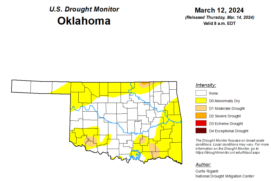
To view the latest Oklahoma drought map, CLICK HERE.
According to the latest Oklahoma drought monitor report, exceptional drought remains at zero percent, unchanged from the start of the calendar year.
Extreme drought or worse remains at zero percent, unchanged from the past 11 weeks.
Severe drought or worse is unchanged from the past four weeks at .19 percent.
Moderate drought or worse is now at 3.82 percent, slightly lower than last week’s 3.85 percent.
Abnormally dry or worse conditions are now at 45.16 percent, up from last week’s 34.61 percent.
According to the 6-to-10-day precipitation outlook map, the southern quarter of the state is leaning above a 33 to 40 percent chance of precipitation through March 23rd. The remaining parts of the state can expect “near normal” precipitation through that March 23rd date.
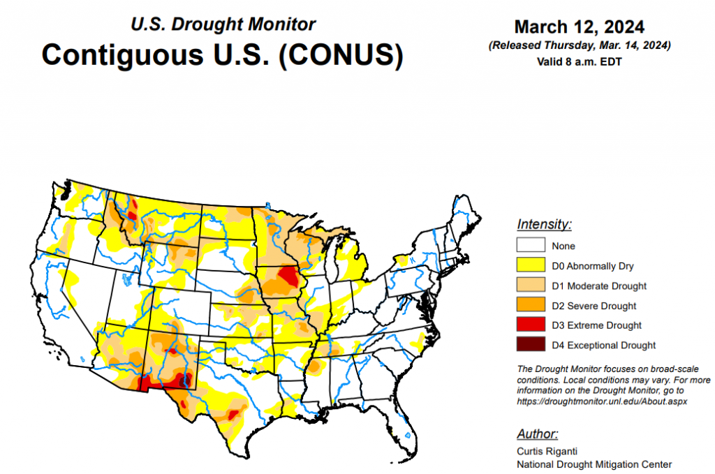
To view the United States Drought Map, click here.
According to the latest U.S. drought monitor report, Moderate to heavy rain amounts fell across parts of the Southeast and Northeast this week, leading to localized improvements to ongoing drought and abnormal dryness in the Southeast, and mostly unchanged conditions in the Northeast, aside from western New York, which missed out on the heavier precipitation and saw minor degradations. The central third of the contiguous U.S. saw a mix of improvements and degradations, based on where heavier precipitation did or did not fall and where dry and windy conditions continued. Parts of Illinois, Indiana, Ohio, the Michigan Lower Peninsula, southern Missouri and southeast Kansas saw improving conditions after heavier rains fell there. Meanwhile, moderate drought expanded in northwest Missouri and portions of west-central Wisconsin, Minnesota, northwest Iowa, the far southern Michigan Upper Peninsula and far northeast Wisconsin. Much of Texas remained the same, with a few degradations in the southeast corner and several degradations in central and southern Texas where long-term drought conditions are still causing impacts. Recent dryness and warm and windy weather in northwest Oklahoma and the Texas and Oklahoma panhandles led to abnormal dryness developing there. Short-term dryness and high evaporative demand led to large areas of degrading conditions in northeast Wyoming, while west-central Wyoming, north-central Colorado, northeast Utah, western Montana, and the northern Idaho Panhandle all saw areas of improvement due to lower evaporative demand and improving snowpack recently. In Hawaii, an active trade wind pattern continued, leading to some improvements on the windward (northeast) slopes of the Big Island and Kauai, while a small area of moderate drought developed on the leeward (southwest) portion of Kauai. In Puerto Rico, a few improvements were made where recent rainfall has improved streamflows and crop stress, and lessened rainfall deficits and raised reservoir levels. No changes were made to the Drought Monitor this week in Alaska.
In the Southern Plains, rainfall amounts this week in the South region varied widely. In western Oklahoma, south Texas, and the Oklahoma and Texas Panhandles, the weather this week was mostly dry. In north-central Texas, portions of Louisiana and Arkansas, central and southern Mississippi, and south-central Tennessee, rainfall accumulations of 1-2 inches occurred, with locally higher amounts. Much of the central and eastern part of the region saw above-normal temperatures, with readings commonly falling into the 2-8 degrees above normal window. In western Texas and the Oklahoma Panhandle, temperatures were generally closer to normal, with most readings falling somewhere between 4 degrees cooler than normal and 4 degrees warmer than normal. In south-central and southeast Tennessee, recent rainfall improved streamflows and precipitation deficits enough to result in improvements. Farther west in west-central and northwest Tennessee and adjacent east-central Arkansas, abnormally dry conditions expanded where short-term precipitation deficits paired with high evaporative demand and lowering streamflow. In areas of recent heavy rainfall in Louisiana, precipitation deficits lessened and soil moisture profiles improved enough for improvements in areas of abnormal dryness and moderate drought. In southeast Texas and nearby southwest Louisiana, abnormal dryness expanded and moderate drought developed where recent dryness and high evaporative demand combined with decreasing soil moisture and streamflow numbers. In central Texas, recent localized dryness occurred on top of long-term dryness and drought, which combined with very low streamflow in many locations to lead to expansion of drought and abnormal dryness areas. In the northeast Texas Panhandle and adjacent Oklahoma Panhandle and northwest Oklahoma, dry weather over the last couple of months combined with high evaporative demand led to the development of abnormal dryness. In these areas, wildfires have been common recently
In the High Plains, eastern parts of the High Plains region were mostly warmer than normal this week, with temperatures 8-10 degrees above normal occurring in the eastern Dakotas. Colder-than-normal weather occurred in western Wyoming and parts of Colorado. Localized heavy rains from severe thunderstorms this week occurred in parts of central and southeast Kansas, leading to localized improvements to ongoing drought and abnormal dryness. In south-central and southwest Kansas, abnormal dryness developed where dry weather from the past couple of months combined with warm and windy conditions, similar to those experienced in northwest Oklahoma and parts of the Texas and Oklahoma panhandles. In southwest Nebraska, localized improvements were made to an area of abnormal dryness after a major snowstorm struck the area. Recent dry, warm and windy weather led to a small expansion of abnormal dryness in northeast Nebraska and far southeast South Dakota. In northeast Wyoming and adjacent southwest South Dakota, recent dry, warm and windy weather led to expansions of abnormal dryness and moderate and severe drought. Recent snowpack improvements in the Wyoming Range of west-central Wyoming and in the Never Summer and Medicine Bow Mountains of northern Colorado led to improvements to ongoing abnormal dryness in both areas.
In the West, temperatures across the West this week were primarily near normal or colder than normal. Compared to normal, the coldest area was southern Idaho, where temperatures mainly ranged from 6-12 degrees below normal. Portions of central and southeast Montana were 3-6 degrees above normal. Heavy precipitation fell in parts of north-central and northwest California, and along the Oregon and Washington coasts. Elsewhere, precipitation also fell in some of the mountainous parts of the northern half of the West region. After recent heavy precipitation in western Oregon and improvements to streamflow and long-term precipitation deficits, an area of abnormal dryness was removed from west-central Oregon. Given recent wetness, further improvements in the area may occur in coming weeks. In western Montana and northern Idaho, recently improved snowpack and lessening precipitation deficits led to several improvements to ongoing drought and abnormally dry conditions. Due to low evaporative demand and improved long-term precipitation deficits, northeast Utah saw reduced coverage of abnormal dryness this week.
Looking ahead, according to forecasts from the National Weather Service Weather Prediction Center, heavy snowfall is forecast in the Colorado Front Range area near the beginning of the forecast period (March 14-15), while heavy precipitation with this storm system is also likely across other parts of the Four Corners states. Aside from portions of the Four Corners states, much of the West is likely to stay dry through Monday evening. Farther east, through Monday evening, half an inch (or more) of precipitation is forecast from central Nebraska eastward into parts of the Rust Belt. Rainfall amounts of a half inch to 2 inches, with locally higher amounts, is also forecast from central Texas eastward through southeast Oklahoma, Arkansas and southeast Missouri to most of Georgia and Tennessee and southern Kentucky.
The National Weather Service Climate Prediction Center 6-10 day forecast favors near-normal precipitation or above-normal precipitation across the contiguous U.S., covering the period from March 19-23. The highest confidence areas for above-normal precipitation are the Florida Peninsula, along the Gulf Coast, and from the Arizona/New Mexico border northward through Montana. Warmer-than-normal temperatures are favored across parts of the West, especially in Utah, Nevada, California, Idaho, Washington and Oregon, and in parts of the central and southern Great Plains. Below-normal temperatures are favored in the Southeast, excluding the southern Florida Peninsula where near- or above-normal temperatures are favored. Below-normal temperatures are also favored from central Montana eastward through North Dakota and northern South Dakota, Minnesota, Wisconsin and Michigan, with below-normal temperatures slightly favored in the Ohio River Valley and Rust Belt.
In Hawaii, cooler-than-normal temperatures are favored. Below-normal precipitation is likely on all islands except for the Big Island, where near-normal precipitation is favored. Warmer-than-normal weather is favored in Alaska, especially in the western reaches of the state. Wetter-than-normal weather is favored for central, northern and western Alaska, while drier-than-normal weather is favored in southeast Alaska.


