

To view the latest Oklahoma drought map, CLICK HERE.
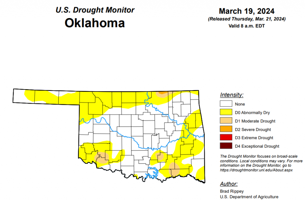
According to the latest Oklahoma drought monitor report, exceptional drought remains at zero percent, unchanged from the start of the calendar year.
Extreme drought or worse remains at zero percent, unchanged from the past 12 weeks.
Severe drought or worse is unchanged from the past five weeks at .19 percent.
Moderate drought or worse is now at 3.53 percent, down slightly from last week’s 3.82 percent.
Abnormally dry or worse conditions are now at 43.56 percent, down from last week’s 45.16 percent.
According to the 6-to-10-day precipitation outlook map, almost the entire state is at a “near normal” chance of precipitation through March 30. A small strip of the southern border of the state is leaning below a 33 to 40 percent chance of precipitation through March 30.
To view the United States Drought Map, click here.
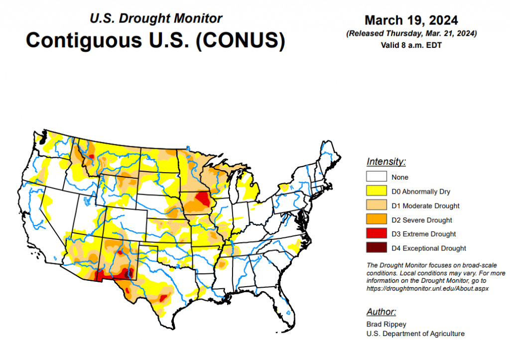
According to the latest U.S. Drought Monitor, during the drought-monitoring period ending March 19, active weather shifted southward from the central Rockies and lower Midwest. Eventually, significant precipitation fell across much of the southern United States. Locally severe thunderstorms were most numerous from the southeastern Plains into the Ohio and Tennessee Valleys. Based on preliminary reports, the mid-March outbreak included more than three dozen tornadoes, one of which resulted in three fatalities in western Ohio on March 14. Meanwhile, the northern Plains and upper Midwest experienced mostly dry weather. Elsewhere, the southern High Plains escaped a short-lived round of windy, dry weather without any major wildfires, unlike the late-February episode. Recovery efforts continued in fire-affected areas, primarily across the Texas Panhandle, but extending to other areas on the central and southern Plains. As the drought-monitoring period progressed, record-setting warmth first retreated from the Midwest and Northeast into the Deep South, then appeared in the Northwest. By March 19, freezes deep into the Southeast threatened a variety of crops, including blooming fruits and winter grains. On that date in Alabama, both Anniston and Tuscaloosa posted daily-record lows of 28°F.
In the Southern Plains, pounding rains totaled 2 to 6 inches or more from southeastern Oklahoma and southern and eastern Texas to the Mississippi Delta. Improvements of up to one category were noted in areas where the heavy rain overlapped existing coverage of moderate to severe drought (D1 to D2), including northern Mississippi and western Tennessee. El Dorado, Arkansas, in an area not affected by drought, endured its wettest day during March on record, with the daily total of 6.31 inches on the 15th surpassing the mark of 5.85 inches set on March 28, 1914. Farther west, showers in Oklahoma and Texas were more scattered, with only targeted drought improvements. In fact, abnormal dryness (D0) expanded in parts of western Oklahoma and environs, as the effects of recent warmth and windy, dry conditions began to reduce topsoil moisture and adversely affect winter wheat. On March 17, according to the U.S. Department of Agriculture, topsoil moisture was rated 49% very short to short in Texas, along with 28% in Oklahoma. On the same date, winter wheat was rated 61% good to excellent (and 7% very poor to poor) in Oklahoma, and 46% good to excellent (and 19% very poor to poor) in Texas.
In the High Plains, generally minor changes in the drought depiction were observed on the High Plains. Some increases in the coverage of abnormal dryness (D0) were noted on the Plains from central and southwestern Kansas northward into parts of South Dakota. Despite the Plains’ pockets of dryness and drought, prospects for the winter wheat crop remained mostly favorable. In Kansas, 55% of the winter wheat was rated in good to excellent condition on March 17, with only 12% of the crop rated very poor to poor, according to the U.S. Department of Agriculture. Meanwhile, some drought reductions occurred in the Rockies of Colorado and Wyoming. In Colorado, March 13-15 snowfall totaled 12.9 inches in Colorado Springs. On the 14th, as rain changed to snow, Pueblo, Colorado, experienced its wettest day during March on record, with 1.53 inches (and 2.5 inches of snow). Previously, Pueblo’s wettest day during March had been March 18, 1998, with 1.26 inches. During the mid-month event, numerous 3- to 5-foot snowfall totals were noted in the Colorado Rockies, with Aspen Springs in Gilpin County receiving 61.5 inches.
In the West, late-season precipitation in the Southwest contrasted with the arrival of record-setting warmth in the Northwest. The Southwestern precipitation, including high-elevation snow, resulted in some generous reductions in drought coverage, especially in parts of Arizona, Colorado, and New Mexico. Meanwhile, warmth appeared in the Northwest, where Quillayute, Washington, set a monthly record with a high of 80°F on March 16. Quillayute’s previous record, 79°F, had been set on March 20, 2019.
Looking ahead, back-to-back storms across the northern United States should produce significant snow from the northern Plains into the upper Great Lakes States. The second storm system, expected to reach peak intensity over the weekend or early next week, has the potential to double season-to-date snowfall totals in parts of the upper Midwest. In addition, wind-driven snow from both storms could complicate rural travel and lead to hardship for Northern cattle, especially newborns. Separately, a late-week storm will produce rain in the southern and eastern United States, with 1- to 3-inch totals possible in portions of the Gulf and Atlantic Coast States. Elsewhere, cool, unsettled weather will return across the West, especially from northern and central California and the Pacific Northwest to the northern Rockies.
The NWS 6- to 10-day outlook for March 26 – 30 calls for near- or above-normal temperatures in the East, while colder-than-normal conditions will stretch from the Pacific Coast to Mississippi Valley. Meanwhile, wetter-than-normal weather will cover the entire country, except the south-central United States, with the greatest likelihood of wet conditions focused across the West and the Southeast.
To view the 6-10 Day Precipitation Outlook Map, click here.
To view the 6-10 Day Temperature Outlook Map, click here.
To view the Monthly Drought Outlook Map, click here.


